Topics (318k) Articles (329k) Users (397) Discussions (237) Comments (383) Files (10k) New article

Submarine groundwater discharge (SGD) refers to the flow of groundwater into the ocean or other bodies of water from underwater aquifers. This process occurs along coastlines, where freshwater from underground aquifers seeps out through sediments and interacts with seawater. SGD can occur in various forms, including: 1. **Diffuse Discharge**: A gradual and widespread movement of groundwater through sediments and into the ocean.
A submarine earthquake is an earthquake that occurs beneath the ocean floor. Like other types of earthquakes, it is caused by the movement of tectonic plates and the release of accumulated stress along geological faults. The seismic waves generated by these earthquakes can vary in intensity and may lead to underwater landslides, tsunamis, and other geological events. Submarine earthquakes can occur at mid-ocean ridges, subduction zones, or transform fault boundaries, and they can significantly affect marine environments and coastal areas.
The South Sandwich Trench is a deep oceanic trench located in the southern Atlantic Ocean, to the southeast of South America. It is the site where the South American Plate is being subducted beneath the Scotia Plate, making it a prominent feature of the Earth's tectonic activity. Key points about the South Sandwich Trench include: 1. **Geography**: The trench is situated near the South Sandwich Islands and extends approximately 1,550 kilometers (about 960 miles) in length.
The South Pacific Convergence Zone (SPCZ) is a region of the South Pacific Ocean characterized by the convergence of trade winds from the southeast and northeast. This convergence zone is typically located roughly between 5° and 15° S latitude and extends from the western Pacific, near the Solomon Islands and Papua New Guinea, to the eastern Pacific, near French Polynesia. Key features of the SPCZ include: 1. **Weather Patterns**: The SPCZ is associated with significant precipitation and thunderstorms.
Significant wave height (often abbreviated as Hs) is a measure used in oceanography and meteorology to quantify the height of waves in a body of water. Specifically, it is defined as the average height of the highest one-third of the waves observed over a specific period. This metric provides a useful representation of the wave conditions because it tends to give a more accurate portrayal of the sea state than simply taking the average of all wave heights.
"Shore lead" typically refers to the leadership role or guidance provided to a team or organization involved in coastal or marine activities, such as environmental conservation, maritime operations, or coastal resource management. This role may involve coordinating efforts, facilitating communication among stakeholders, and ensuring that projects align with organizational goals and policies related to shoreline management.
The term "shoal" can refer to a few different concepts, depending on the context: 1. **Geographical Feature**: In geography, a shoal is a natural landform that consists of a shallow part of a body of water. Shoals can be found in oceans, seas, rivers, and lakes and can pose hazards to navigation because they can be difficult to see, especially at high tide. They can be formed from sand, silt, and other sediments.
Seawater is water from the world's oceans and seas, characterized primarily by its high salt content. On average, seawater has a salinity of about 35 parts per thousand (ppt), meaning that in every liter of seawater, there are approximately 35 grams of dissolved salts, mainly sodium chloride (table salt). Other components of seawater include various minerals, dissolved gases (such as oxygen and carbon dioxide), organic matter, and microorganisms.
A seamount is an underwater mountain that rises from the ocean floor but does not reach the surface of the water. Seamounts are typically formed by volcanic activity and are usually found in oceanic regions. They can vary in height and size, and they often have steep slopes, with some reaching significant elevations above the surrounding sea floor. Seamounts can serve as important habitats for marine life, providing unique ecosystems that support a variety of species, including corals, fish, and other organisms.
The relationship between seafloor depth and age is a key concept in geology and oceanography, particularly in the context of plate tectonics and the formation of the ocean floor. Here's an overview of this relationship: 1. **Seafloor Spreading**: The seafloor is continuously formed through volcanic activity at mid-ocean ridges, where tectonic plates diverge. As magma rises from the mantle and solidifies, new oceanic crust is created.
Sea foam, also known as ocean foam, is a light, frothy substance that occurs in marine environments, particularly along coastlines. It is formed when the agitation of seawater (due to wind, waves, and currents) causes organic matter, such as proteins, lipids, and oils, to be emulsified and whipped into bubbles. These bubbles can accumulate and create a foamy layer on the surface of the water.
SeaDataNet is a European marine data infrastructure aimed at providing access to and promoting the use of marine data and information. It facilitates the management and sharing of marine data collected from various sources, including research institutions, governmental agencies, and other organizations involved in marine science and oceanography.
Salt fingering is a physical oceanographic process that occurs primarily in ocean waters where strong vertical salinity gradients exist, typically in regions where lighter freshwater overlays denser saltwater. It is particularly notable in areas like estuaries and regions affected by river outflows. The process involves the interplay of temperature and salinity, which can cause instability in the water column.
A rotor current meter is an instrument used to measure the velocity of flowing water in rivers, streams, or other water bodies. It operates on the principle of measuring the rotational speed of a rotor (or impeller) that is set in motion by the flow of water. As water passes over or through the rotor, it causes the rotor to spin, and the speed of this rotation correlates with the velocity of the water.
The "Rossby whistle" refers to a phenomenon related to the dynamics of fluid motion in geophysical contexts, particularly in atmosphere and oceanography. It is associated with Rossby waves, which are large-scale waves in a rotating fluid, such as the Earth's atmosphere and oceans, caused by the Coriolis effect due to the planet's rotation.
A Rossby wave is a type of wave that occurs in rotating fluids, such as the Earth's atmosphere and oceans, due to the Coriolis effect. These waves are significant in meteorology and oceanography because they play a crucial role in the motion of weather systems and ocean currents. In the atmosphere, Rossby waves are characterized by large-scale meanders in high-altitude winds, particularly in the westerlies, and are influenced by the planet's rotation.
Rossby-gravity waves are a type of wave that occurs in rotating fluids, such as the Earth's atmosphere and oceans. They are the result of the interplay between the effects of Earth's rotation (Coriolis effect) and gravity, and they play a crucial role in understanding atmospheric and oceanic dynamics. ### Key Features: 1. **Components**: - **Rossby Waves**: These arise primarily due to the rotation of the Earth and the conservation of angular momentum.
A river plume is a body of freshwater that is released from a river and disperses into a larger body of water, such as an ocean or sea. This process often occurs where the river meets the sea, creating a distinct zone where freshwater from the river mixes with the saltwater from the ocean. River plumes can have significant ecological effects, influencing water salinity, temperature, nutrient levels, and the distribution of marine life.
A rip tide, commonly referred to as a rip current, is a powerful, narrow channel of water that flows away from the shore. It is often created when water from breaking waves accumulates in shallow areas and is funneled back out to sea, creating a strong current. Rip currents can be dangerous for swimmers because they can pull individuals away from the shore very quickly.
A rip current, often referred to simply as a rip, is a strong, narrow channel of water that flows away from the shore. These currents can form when water from waves that break on the beach returns to the sea through a gap in the sandbars or along the beach. Rip currents can occur at any beach with breaking waves and can be particularly dangerous for swimmers and surfers due to their strong pull away from the shore.
Pinned article: Introduction to the OurBigBook Project
Welcome to the OurBigBook Project! Our goal is to create the perfect publishing platform for STEM subjects, and get university-level students to write the best free STEM tutorials ever.
Everyone is welcome to create an account and play with the site: ourbigbook.com/go/register. We belive that students themselves can write amazing tutorials, but teachers are welcome too. You can write about anything you want, it doesn't have to be STEM or even educational. Silly test content is very welcome and you won't be penalized in any way. Just keep it legal!
Intro to OurBigBook
. Source. We have two killer features:
- topics: topics group articles by different users with the same title, e.g. here is the topic for the "Fundamental Theorem of Calculus" ourbigbook.com/go/topic/fundamental-theorem-of-calculusArticles of different users are sorted by upvote within each article page. This feature is a bit like:
- a Wikipedia where each user can have their own version of each article
- a Q&A website like Stack Overflow, where multiple people can give their views on a given topic, and the best ones are sorted by upvote. Except you don't need to wait for someone to ask first, and any topic goes, no matter how narrow or broad
This feature makes it possible for readers to find better explanations of any topic created by other writers. And it allows writers to create an explanation in a place that readers might actually find it.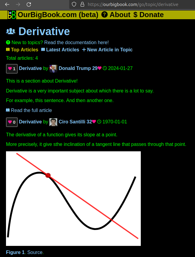
Figure 1. Screenshot of the "Derivative" topic page. View it live at: ourbigbook.com/go/topic/derivativeVideo 2. OurBigBook Web topics demo. Source. - local editing: you can store all your personal knowledge base content locally in a plaintext markup format that can be edited locally and published either:This way you can be sure that even if OurBigBook.com were to go down one day (which we have no plans to do as it is quite cheap to host!), your content will still be perfectly readable as a static site.
- to OurBigBook.com to get awesome multi-user features like topics and likes
- as HTML files to a static website, which you can host yourself for free on many external providers like GitHub Pages, and remain in full control

Figure 2. You can publish local OurBigBook lightweight markup files to either OurBigBook.com or as a static website.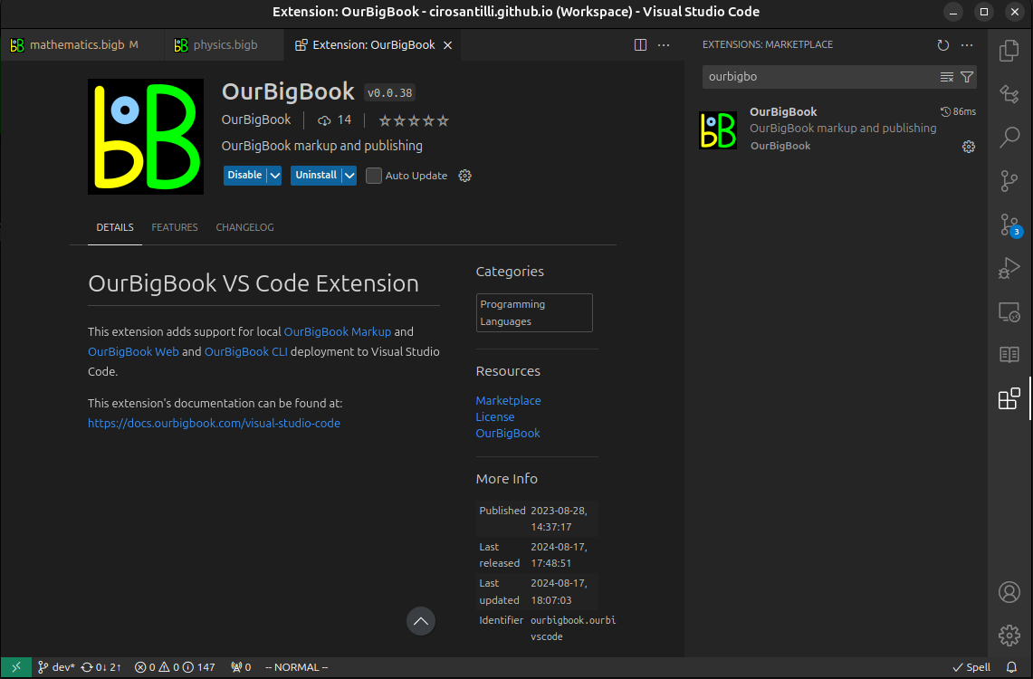
Figure 3. Visual Studio Code extension installation.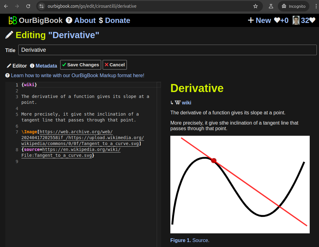
Figure 5. . You can also edit articles on the Web editor without installing anything locally. Video 3. Edit locally and publish demo. Source. This shows editing OurBigBook Markup and publishing it using the Visual Studio Code extension. 
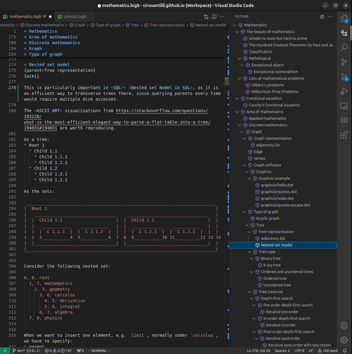
- Infinitely deep tables of contents:
All our software is open source and hosted at: github.com/ourbigbook/ourbigbook
Further documentation can be found at: docs.ourbigbook.com
Feel free to reach our to us for any help or suggestions: docs.ourbigbook.com/#contact