A Sun-synchronous orbit maintains approximately constant orientation relative to the mean Sun, so corresponding passes over a location occur at nearly the same local solar time. It is usually a nearly polar, slightly retrograde low Earth orbit. Earth rotates beneath the successive tracks, allowing broad coverage; the satellite is not stationary over a location and does not necessarily revisit that location every day.
It is attained by selecting altitude, orbital eccentricity and orbital inclination so that nodal precession caused by Earth's equatorial bulge matches the mean apparent annual motion of the Sun, about per year eastward. To leading order,Here is the semi-major axis, the orbital eccentricity, the orbital inclination, the mean motion, and Earth's dimensionless quadrupole coefficient. A retrograde inclination has , giving the required positive precession; typical imaging altitudes yield inclinations around –. The launch establishes the required orbital plane, and subsequent orbit maintenance limits drift.
This geometry suits repeated optical and multispectral imaging of land, vegetation and oceans, because comparable local time reduces illumination and shadow differences. Landsat and Sentinel-2 are examples. Radar missions such as Sentinel-1 also use this orbit for regular global sampling even though their illumination is supplied by the radar. Constant local time helps comparison but does not remove seasonal changes in solar elevation.[ref]
Catalog of Earth satellite orbits by NASA Earth Observatory. “Polar Orbits” and “Sun-Synchronous Orbits”: near-polar global sampling and controlled precession maintaining local solar time.
A geostationary orbit is a circular, prograde, equatorial orbit with period equal to one sidereal day, approximately . Its satellite therefore remains above one longitude on the equator. Merely having a one-day period gives a geosynchronous orbit; an inclined or eccentric version still moves across the ground observer's sky.
Balancing gravitational acceleration and centripetal acceleration givesOne route is injection into an elliptical geostationary transfer orbit, followed by a burn near apogee to circularize and remove the remaining inclination; direct or low-thrust transfers are also possible. Subsequent station keeping controls longitude, inclination and eccentricity.
The fixed wide view permits frequent observations of weather, clouds and rapidly changing storms, as in Meteosat and GOES. The tradeoffs are large range, generally coarser spatial sampling for comparable optics, oblique views at high latitudes and poor polar coverage. It is valuable for following change through the day rather than obtaining global coverage with one spacecraft.[ref]
Catalog of Earth satellite orbits by NASA Earth Observatory. “High Earth Orbit”: geosynchronous radius, the circular/equatorial conditions for geostationarity, and weather-monitoring applications.
Healthy green vegetation has strong visible absorption in the blue, around –, and red, around –, mainly from chlorophylls and other photosynthetic pigments. Weaker absorption around green wavelengths produces a relative reflectance maximum near and the familiar green appearance. The red edge is the steep reflectance rise around –. In the near-infrared, weak pigment absorption and multiple scattering at internal leaf tissue–air interfaces produce high reflectance, commonly a broad plateau. This plateau is primarily a structural scattering effect, rather than chlorophyll reflecting the light.[ref]
Measuring vegetation by NASA Earth Observatory. “Normalized Difference Vegetation Index”: contrast between chlorophyll absorption of visible light and strong near-infrared scattering by leaf structure.
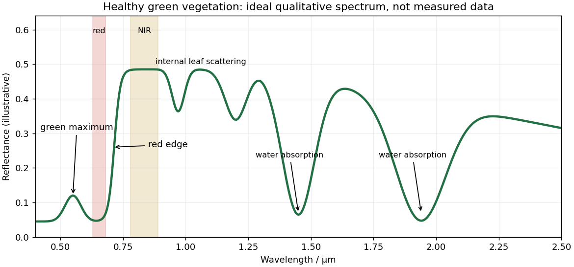
Qualitative reflectance spectrum of healthy green vegetation
. Original synthetic leaf spectrum with a green maximum, red absorption, red edge, near-infrared plateau and shortwave-infrared water absorption troughs. The curve is illustrative rather than measured; shaded bands exemplify red and near-infrared measurements for a vegetation index. Details.
Leaf water produces absorption troughs in the shortwave infrared, especially near and , with weaker features near and . Atmospheric water vapor also strongly absorbs near and , so satellite bands usually avoid the centres of those deep troughs. Drying, senescence, pigment loss and changes in canopy structure alter the spectrum; measured canopy reflectance also includes shadows and the soil background.
To highlight vegetation, assign the near-infrared band to the red display channel, red to green and green to blue: vigorously vegetated areas appear bright red in this conventional false-colour composite. Alternatively calculate the normalized difference vegetation index from atmospherically corrected, spatially registered red and near-infrared reflectances:Large positive values indicate a strong vegetation-like red/NIR contrast. For example, and give about . Mask clouds, their shadows and invalid low-signal pixels. Bare soil usually has a smaller contrast, while water often has negative values; fixed universal thresholds are inappropriate, and dense vegetation can saturate the index. A band ratio improves contrast but is not a direct count of plants or a unique measure of physiological health.[ref]
Measuring vegetation by NASA Earth Observatory. “Normalized Difference Vegetation Index”: normalized red/near-infrared contrast and interpretation of green vegetation.
Articles by others on the same topic
There are currently no matching articles.