The problem of religious language refers to the philosophical and theological challenges associated with expressing religious beliefs and experiences through language. This issue encompasses several key aspects: 1. **Ambiguity and Vagueness**: Religious language often contains terms that are open to multiple interpretations. For example, words like "God," "spirit," or "salvation" can vary significantly in meaning across different religious traditions or even within the same tradition.
The ELSV formula (named after its creators Ederington, Lee, Stulz, and Visscher) is a method used in finance for estimating the price of options. It is particularly associated with the pricing of employee stock options and is a variant of the Black-Scholes model.
The Mantel test is a statistical method used to assess the correlation between two distance or dissimilarity matrices. It's commonly applied in fields like ecology, genetics, and geography to determine whether there is a significant relationship between two sets of distances, such as geographic distances between sites and genetic distances among populations. ### Key Features of the Mantel Test: 1. **Distance Matrices**: The test involves two matrices that represent pairwise distances or dissimilarities.
Rencontres numbers are a sequence of integers that arise in combinatorial mathematics, specifically in the context of permutations. They count the number of permutations of a set of \( n \) elements where exactly \( k \) elements are in their original (or "fixed") positions. The term "rencontre" comes from a French word meaning "meeting," reflecting the idea of elements meeting their original positions.
In the context of group theory and specifically permutations, the terms "skew" and "direct sums" can relate to how we combine or relate different permutation groups or works within them. ### Skew of Permutations "Skew" isn't a standard term strictly associated with permutations in the same way that "direct sum" is, but it may refer to a concept such as a "skew product".
A transposition cipher is a method of encryption where the positions of the letters in the plaintext are shifted according to a certain system to create the ciphertext. Unlike substitution ciphers, which replace letters or groups of letters with other letters or groups, transposition ciphers rearrange the existing characters without changing them. ### Key Features of Transposition Ciphers: 1. **Rearrangement**: The primary mechanism behind a transposition cipher is the rearrangement of characters in the plaintext to produce the ciphertext.
Al-Khazini, also known as Al-Khazini Al-Baghdadi, was a prominent Arab physicist, mathematician, and astronomer who lived during the 11th or 12th century (often cited around 1050-1115 CE). He is best known for his work in mechanics and his contributions to the understanding of gravitational and hydrostatic principles.
In philosophy, "interpretation" refers to the process of understanding and making sense of texts, ideas, actions, or phenomena. It involves deciphering meaning and significance, often in contexts that are complex or ambiguous. Interpretation can apply to various fields within philosophy, including literature, ethics, metaphysics, and social and political theory.
Philosophy of language is a branch of philosophy that explores the nature, origins, and use of language. It examines how language interacts with reality, thought, and communication, and it addresses questions such as: 1. **Meaning**: What does it mean for words and sentences to have meaning? How do meanings change over time or in different contexts? 2. **Reference**: How do linguistic expressions refer to objects, concepts, or states of affairs?
A non-rigid designator is a term from philosophy and the philosophy of language that refers to expressions or terms that do not consistently refer to the same object or entity across different contexts or possible worlds. In other words, a non-rigid designator is a term whose reference can change depending on the circumstances or the specific context in which it is used.
The "Hopi Time Controversy" refers to a cultural and philosophical debate regarding the concept of time as understood by the Hopi people of northeastern Arizona, particularly in relation to Western notions of time. This controversy was brought to broader public attention by the work of anthropologist Frank Waters and later by linguist and researcher Benjamin Whorf.
The "linguistic turn" is a philosophical movement and paradigm shift that emphasizes the importance of language in shaping our understanding of reality, knowledge, and meaning. It emerged in the early 20th century and has been influential in various fields, including philosophy, linguistics, literary theory, and social sciences.
Universal pragmatics is a theoretical concept developed primarily by the German philosopher Jürgen Habermas, which seeks to establish a foundation for understanding human communication and the conditions that make it possible. Habermas introduced this concept in the context of his broader theory of communicative action, which aims to explore the structures of social interaction and the processes of understanding in human discourse.
Metaphysics of science is a branch of philosophy that explores the foundational, abstract concepts and questions that underlie scientific inquiry and practice. It addresses fundamental issues related to the nature of scientific theories, the structure of scientific explanations, and the implications of scientific discoveries.
Radical translation is a concept in the field of philosophy of language and specifically in the study of semantics and meaning. The term is often associated with the work of philosopher W.V.O. Quine, particularly his views on language, meaning, and translation. In his essay "Word and Object," Quine discusses the challenges of translating one language into another, especially when the two languages have no common reference point or shared experience.
Artillery units and formations refer to military organizations that specialize in the use of large-caliber guns, howitzers, rockets, and missile systems to support ground troops, provide fire support, and engage enemy forces from a distance. These units are crucial for both offensive and defensive operations in modern warfare. Here's an overview: ### Types of Artillery 1. **Field Artillery**: This includes mobile artillery units that support ground troops with indirect fire.
A truth-value link typically refers to a relationship or connection between propositions, statements, or expressions in formal logic that indicates their truth values (true or false). In logical systems, particularly in propositional logic, each proposition has a truth value of either true (T) or false (F). Truth-value links can be used to explore how the truth of one proposition affects the truth of another.
In Eastern philosophy, the concept of "mind" is multifaceted and varies across different traditions, such as Hinduism, Buddhism, Taoism, and Confucianism. Here is an overview of how "mind" is understood in some of these traditions: ### Hinduism 1. **Manas**: In Hindu philosophy, particularly in the Samkhya and Vedanta schools, the mind is often referred to as "manas.
Causality refers to the relationship between causes and effects, where one event (the cause) leads to the occurrence of another event (the effect). In other words, causality implies that certain conditions or events result in or contribute to the happening of other conditions or events. Understanding causality is essential in various fields, including philosophy, science, statistics, and everyday reasoning, as it helps in making predictions, understanding phenomena, and making informed decisions.
The Center for Philosophy of Science is an academic research center typically associated with the study of the philosophical aspects of science. It focuses on the nature, methodology, and implications of scientific practice and knowledge. The center often hosts research projects, lectures, seminars, and conferences, bringing together philosophers, scientists, and scholars from various fields to engage in discussions about the foundations and implications of scientific inquiry.
Pinned article: Introduction to the OurBigBook Project
Welcome to the OurBigBook Project! Our goal is to create the perfect publishing platform for STEM subjects, and get university-level students to write the best free STEM tutorials ever.
Everyone is welcome to create an account and play with the site: ourbigbook.com/go/register. We belive that students themselves can write amazing tutorials, but teachers are welcome too. You can write about anything you want, it doesn't have to be STEM or even educational. Silly test content is very welcome and you won't be penalized in any way. Just keep it legal!
Intro to OurBigBook
. Source. We have two killer features:
- topics: topics group articles by different users with the same title, e.g. here is the topic for the "Fundamental Theorem of Calculus" ourbigbook.com/go/topic/fundamental-theorem-of-calculusArticles of different users are sorted by upvote within each article page. This feature is a bit like:
- a Wikipedia where each user can have their own version of each article
- a Q&A website like Stack Overflow, where multiple people can give their views on a given topic, and the best ones are sorted by upvote. Except you don't need to wait for someone to ask first, and any topic goes, no matter how narrow or broad
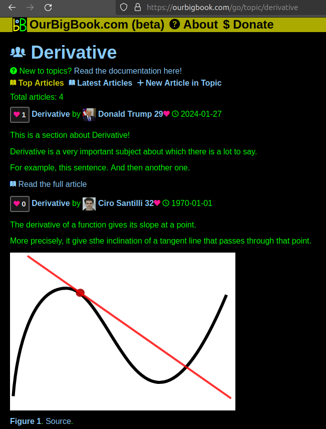
This feature makes it possible for readers to find better explanations of any topic created by other writers. And it allows writers to create an explanation in a place that readers might actually find it.Figure 1. Screenshot of the "Derivative" topic page. View it live at: ourbigbook.com/go/topic/derivativeVideo 2. OurBigBook Web topics demo. Source. - local editing: you can store all your personal knowledge base content locally in a plaintext markup format that can be edited locally and published either:This way you can be sure that even if OurBigBook.com were to go down one day (which we have no plans to do as it is quite cheap to host!), your content will still be perfectly readable as a static site.
- to OurBigBook.com to get awesome multi-user features like topics and likes
- as HTML files to a static website, which you can host yourself for free on many external providers like GitHub Pages, and remain in full control
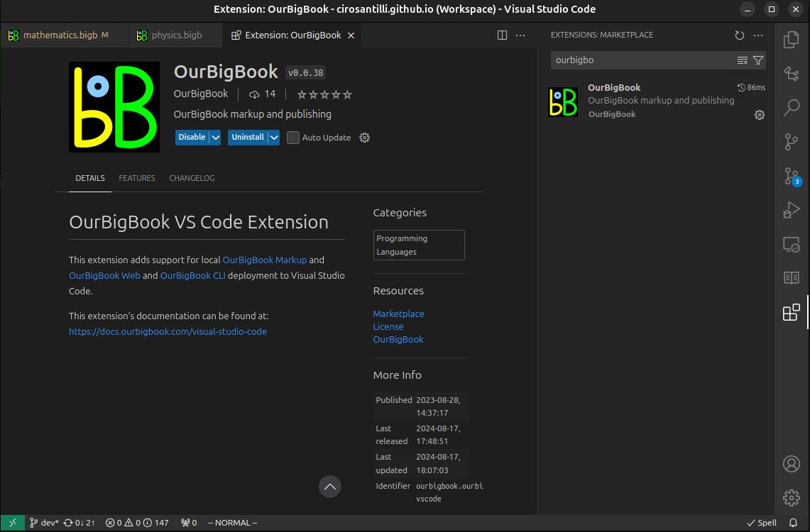
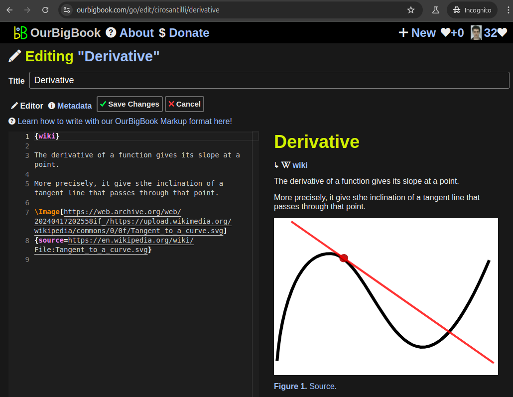
Figure 3. Visual Studio Code extension installation.Figure 4. Visual Studio Code extension tree navigation.Figure 5. Web editor. You can also edit articles on the Web editor without installing anything locally.Video 3. Edit locally and publish demo. Source. This shows editing OurBigBook Markup and publishing it using the Visual Studio Code extension.Video 4. OurBigBook Visual Studio Code extension editing and navigation demo. Source. - Infinitely deep tables of contents:
All our software is open source and hosted at: github.com/ourbigbook/ourbigbook
Further documentation can be found at: docs.ourbigbook.com
Feel free to reach our to us for any help or suggestions: docs.ourbigbook.com/#contact


