The National Agricultural Statistics Service (NASS) is an agency within the United States Department of Agriculture (USDA). It is responsible for collecting, analyzing, and disseminating agricultural data and statistics. The primary goal of NASS is to provide accurate and timely information about the agricultural sector, which includes data on crop production, livestock, farm economics, and agricultural resources.
The National Water and Climate Center (NWCC) is part of the United States Department of Agriculture's Natural Resources Conservation Service (NRCS). Located in Portland, Oregon, the NWCC focuses on analyzing and providing data related to water supply and climate. Its primary responsibilities include: 1. **Snowpack and Water Supply Monitoring**: The NWCC monitors snowpack levels across the western United States, which play a critical role in determining water supply for agriculture, municipalities, and ecosystems.
The National Bureau of Statistics (NBS) of China is a government agency responsible for collecting, analyzing, and disseminating statistical data related to the economy, population, and society of China. It operates under the jurisdiction of the State Council of the People's Republic of China. The NBS plays a crucial role in providing essential statistical information that supports government policy-making and the implementation of economic and social development strategies.
The National Institute of Statistics (Instituto Nacional de Estatística, INE) in Mozambique is the government agency responsible for coordinating and implementing national statistical activities in the country. Established in 1990, the INE plays a crucial role in providing reliable statistical information to support economic and social development, policymaking, and planning.
The National Institute of Statistics and Census (Instituto Nacional de Estadística y Censos, INEC) of Costa Rica is the governmental body responsible for collecting, analyzing, and disseminating statistical data in the country. Established in 1945, the INEC plays a crucial role in providing reliable and accurate statistical information that serves as a foundation for policy-making, social planning, and academic research.
The National Postsecondary Student Aid Study (NPSAS) is a comprehensive study conducted by the U.S. Department of Education that collects and analyzes data on the financial aid received by postsecondary students in the United States. NPSAS is part of the National Center for Education Statistics (NCES) and is designed to provide insights into how students finance their education, including information on federal, state, institutional, and private financial aid.
The Statistics Department in Anguilla is a governmental body responsible for collecting, analyzing, and disseminating statistical data related to various aspects of the territory's economy, population, and social indicators. This department provides essential information that supports policy-making, economic planning, and social development initiatives. The responsibilities of the Statistics Department typically include: 1. **Data Collection**: Conducting surveys and censuses to gather information on demographics, labor, health, and other socio-economic factors.
The National Statistics Institute (Instituto Nacional de Estadísticas - INE) of Chile is the government agency responsible for collecting, analyzing, and disseminating statistical data in the country. Established in 1843, the INE plays a crucial role in providing reliable statistics that are essential for public policy, economic planning, and research.
The State Statistics Service of Ukraine (Ukrainian: Державна служба статистики України) is a government agency responsible for the collection, analysis, and dissemination of statistical data in Ukraine. Its primary functions include: 1. **Data Collection**: Gathering statistical information on various aspects of the economy, demographics, agriculture, employment, health, education, and other social issues.
The Neighbourhood Statistics Service refers to a system or platform that provides access to a wide range of data and statistics about specific geographical areas, typically at the level of neighborhoods, local authorities, or communities. It often includes demographic information, economic data, social indicators, and various other statistics that can help inform decision-making, research, and community planning.
The North American Transportation Statistics Interchange (NATSI) is a collaborative effort designed to improve the coordination and availability of transportation statistics across North America. It typically involves federal agencies and transportation authorities from the United States, Canada, and Mexico. The main purpose of NATSI is to enhance the accuracy, consistency, and accessibility of transportation data, which is vital for policymaking, transportation planning, and research.
The ONS Open Geography Portal is a platform provided by the Office for National Statistics (ONS) in the United Kingdom. It offers access to a wide range of geographical data and resources relating to the UK. The portal is designed to facilitate the discovery and use of geographic information, enabling users to explore and visualize geographical datasets, maps, and boundaries used in statistical analysis.
The ONS Postcode Directory, produced by the Office for National Statistics (ONS) in the United Kingdom, is a comprehensive dataset that provides information about postcodes in England, Wales, Scotland, and Northern Ireland. This directory includes various details associated with each postcode, such as geographic boundaries, statistical areas, demographic data, and other relevant information that helps facilitate analysis and reporting for a range of purposes, including public policy, research, and planning.
The term "gauge" can refer to various measurements depending on the context, such as wire gauge, pipe gauge, or shotgun gauge. Here’s a breakdown of a few common types of gauges: 1. **Wire Gauge**: In the context of electrical wire, gauge refers to the diameter of the wire. The American Wire Gauge (AWG) system is commonly used in the United States. A lower gauge number indicates a thicker wire, and a higher gauge number indicates a thinner wire.
The Statistical Center of Iran (SCI) is the main governmental organization responsible for collecting, processing, analyzing, and disseminating statistical data in Iran. Established to provide reliable and accurate statistical information to support decision-making and policy formulation, the SCI plays a critical role in various areas, including economics, demographics, social issues, and public health.
The International Ice Patrol (IIP) is an organization established to monitor and provide information about icebergs in the North Atlantic Ocean, particularly in areas where shipping lanes intersect with potential iceberg hazards. It was formed in 1914 in response to the sinking of the RMS Titanic in 1912, which highlighted the dangers posed by icebergs to maritime safety.
Pinned article: Introduction to the OurBigBook Project
Welcome to the OurBigBook Project! Our goal is to create the perfect publishing platform for STEM subjects, and get university-level students to write the best free STEM tutorials ever.
Everyone is welcome to create an account and play with the site: ourbigbook.com/go/register. We belive that students themselves can write amazing tutorials, but teachers are welcome too. You can write about anything you want, it doesn't have to be STEM or even educational. Silly test content is very welcome and you won't be penalized in any way. Just keep it legal!
Intro to OurBigBook
. Source. We have two killer features:
- topics: topics group articles by different users with the same title, e.g. here is the topic for the "Fundamental Theorem of Calculus" ourbigbook.com/go/topic/fundamental-theorem-of-calculusArticles of different users are sorted by upvote within each article page. This feature is a bit like:
- a Wikipedia where each user can have their own version of each article
- a Q&A website like Stack Overflow, where multiple people can give their views on a given topic, and the best ones are sorted by upvote. Except you don't need to wait for someone to ask first, and any topic goes, no matter how narrow or broad
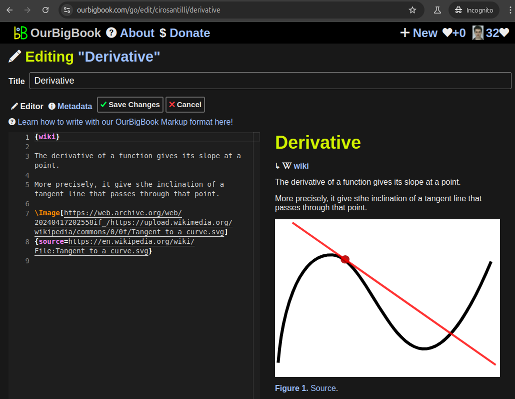
This feature makes it possible for readers to find better explanations of any topic created by other writers. And it allows writers to create an explanation in a place that readers might actually find it.Figure 1. Screenshot of the "Derivative" topic page. View it live at: ourbigbook.com/go/topic/derivativeVideo 2. OurBigBook Web topics demo. Source. - local editing: you can store all your personal knowledge base content locally in a plaintext markup format that can be edited locally and published either:This way you can be sure that even if OurBigBook.com were to go down one day (which we have no plans to do as it is quite cheap to host!), your content will still be perfectly readable as a static site.
- to OurBigBook.com to get awesome multi-user features like topics and likes
- as HTML files to a static website, which you can host yourself for free on many external providers like GitHub Pages, and remain in full control
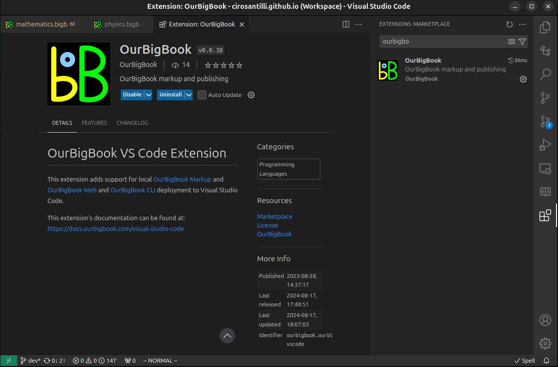
Figure 3. Visual Studio Code extension installation.Figure 4. Visual Studio Code extension tree navigation.Figure 5. Web editor. You can also edit articles on the Web editor without installing anything locally.Video 3. Edit locally and publish demo. Source. This shows editing OurBigBook Markup and publishing it using the Visual Studio Code extension.Video 4. OurBigBook Visual Studio Code extension editing and navigation demo. Source. - Infinitely deep tables of contents:
All our software is open source and hosted at: github.com/ourbigbook/ourbigbook
Further documentation can be found at: docs.ourbigbook.com
Feel free to reach our to us for any help or suggestions: docs.ourbigbook.com/#contact


