Chorography is a branch of geography that focuses on the description and mapping of particular regions or areas. It involves the study of the physical and cultural characteristics of specific places, emphasizing their spatial relationships, landforms, climate, vegetation, and human activities. Chorographers produce detailed accounts of landscapes, often combining cartography, environmental studies, and local history to provide a comprehensive view of a region.
A formal system is a structured framework designed to derive theorems from a set of axioms through formal rules of inference. It consists of several key components: 1. **Alphabet**: A finite set of symbols used to construct expressions and statements within the system. 2. **Language**: The formal expressions are defined using the symbols of the alphabet based on specific grammatical rules. This includes both syntactic rules (how symbols can be combined) and semantic rules (meaning of the expressions).
Cultural mapping is a process that involves documenting, analyzing, and visualizing the cultural resources, activities, and dynamics of a specific community or region. It provides a way to understand the cultural landscape by identifying the various elements that contribute to the identity and character of a place. These elements can include: 1. **Cultural Assets**: This encompasses historical sites, museums, art galleries, theaters, libraries, and other institutions that play a role in the cultural life of the community.
A Digital Raster Graphic (DRG) is a type of digital image that represents rasterized data, typically derived from scanned maps or other source documents. DRGs are commonly used in geographic information systems (GIS) and cartography to provide a digital version of paper maps or aerial photographs. The key characteristics of DRGs include: 1. **Raster Format**: This means that the image is composed of a grid of pixels, where each pixel represents a color or a value.
The Ordnance Survey Great Britain County Series refers to a collection of detailed historical maps produced by the Ordnance Survey, the national mapping agency for Great Britain. These maps were created primarily during the late 19th century and early 20th century, specifically from the 1850s up to the 1940s.
Phantom settlement generally refers to a situation in finance or legal contexts where a transaction appears to have occurred, but no actual change in ownership or value has taken place. This term can be used in a few different ways, depending on the context. 1. **Finance and Accounting**: In finance, a phantom settlement might refer to accounting entries that reflect transactions for reporting purposes but do not result in physical transfer of assets or cash.
The Qinling–Huaihe Line is an important geographical and climatic dividing line in China. It stretches approximately from the Qinling Mountains in the west to the Huaihe River in the east. This line is significant because it separates the northern and southern parts of China, which have distinct climate, culture, and economic characteristics.
The Steinhaus longimeter is a mathematical tool used primarily in the field of geometric measurements. It is designed to measure lengths in a more versatile and flexible manner than traditional measuring devices. The longimeter allows for the determination of the length of curves and complex shapes, which can be particularly useful in both theoretical and applied mathematics. The device operates on principles of geometry and can be particularly advantageous for tasks that involve irregular or non-linear measurements.
Superimposition refers to the process of placing one element over another in such a way that the two elements coexist, allowing for comparison or a combined effect. This term can be applied in various fields, such as: 1. **Art and Design**: In visual arts, superimposition might involve layering images or patterns to create new visual compositions.
"Triangulation" is a novel by the author, who explores themes of human relationships, identity, and the complexities of love through the interactions of its characters. The narrative often delves into the emotional and psychological aspects of the characters, examining how their connections shape their lives. The novel typically features multiple perspectives or a non-linear narrative structure, which allows for a deeper understanding of the characters and their motivations.
Virtual Geographic Environments (VGEs) refer to computer-generated, interactive representations of geographical spaces that allow users to visualize, explore, and interact with geographic data in a simulated context. VGEs combine geographic information systems (GIS), virtual reality (VR), and augmented reality (AR) technologies to create immersive experiences where users can navigate 2D or 3D representations of real or imagined places.
Volume cartography is a technique used to represent and analyze spatial data in three-dimensional (3D) formats. Unlike traditional cartography, which focuses primarily on two-dimensional maps, volume cartography deals with the visualization and interpretation of data that occupy a three-dimensional space.
The EPSG Geodetic Parameter Dataset, maintained by the European Petroleum Survey Group (EPSG), is a detailed database that provides authoritative descriptions of geodetic parameters. It includes information about coordinate reference systems (CRS), geodetic datums, coordinate transformations, and related geospatial information used in mapping, navigation, and geographic information systems (GIS).
"Earth section paths" is not a widely recognized term, and without additional context, it can be challenging to determine its exact meaning. However, it could refer to several concepts, depending on the context in which it is used: 1. **Earth Science**: In geology or earth sciences, the term could relate to the study of different layers or sections of the Earth, such as the crust, mantle, outer core, and inner core.
The Equator is an imaginary line that divides the Earth into the Northern Hemisphere and the Southern Hemisphere. It is located equidistant from the North and South Poles and is situated at 0 degrees latitude. The Equator is significant in various ways: 1. **Geographical Significance**: The Equator serves as the starting point for measuring latitude. Locations north of the Equator have positive latitude values (up to 90 degrees), while those south have negative latitude values.
Geodynamics is the branch of geoscience that studies the processes and forces that shape the Earth's structure and behavior over geological timescales. It focuses on understanding the dynamics of the Earth's interior, including the movement of tectonic plates, the behavior of mantle convection, and the mechanisms of earthquakes and volcanic activity.
Pinned article: Introduction to the OurBigBook Project
Welcome to the OurBigBook Project! Our goal is to create the perfect publishing platform for STEM subjects, and get university-level students to write the best free STEM tutorials ever.
Everyone is welcome to create an account and play with the site: ourbigbook.com/go/register. We belive that students themselves can write amazing tutorials, but teachers are welcome too. You can write about anything you want, it doesn't have to be STEM or even educational. Silly test content is very welcome and you won't be penalized in any way. Just keep it legal!
Intro to OurBigBook
. Source. We have two killer features:
- topics: topics group articles by different users with the same title, e.g. here is the topic for the "Fundamental Theorem of Calculus" ourbigbook.com/go/topic/fundamental-theorem-of-calculusArticles of different users are sorted by upvote within each article page. This feature is a bit like:
- a Wikipedia where each user can have their own version of each article
- a Q&A website like Stack Overflow, where multiple people can give their views on a given topic, and the best ones are sorted by upvote. Except you don't need to wait for someone to ask first, and any topic goes, no matter how narrow or broad
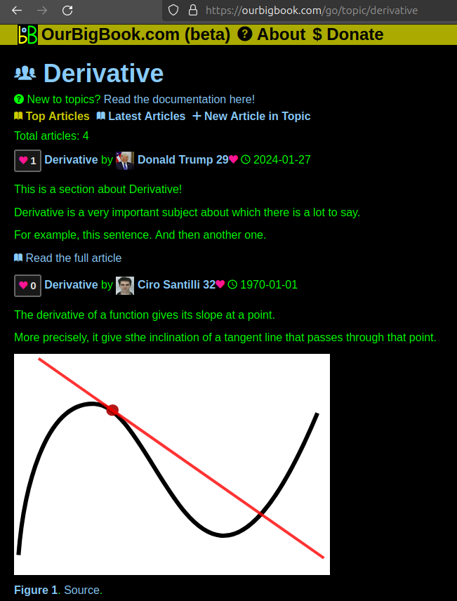
This feature makes it possible for readers to find better explanations of any topic created by other writers. And it allows writers to create an explanation in a place that readers might actually find it.Figure 1. Screenshot of the "Derivative" topic page. View it live at: ourbigbook.com/go/topic/derivativeVideo 2. OurBigBook Web topics demo. Source. - local editing: you can store all your personal knowledge base content locally in a plaintext markup format that can be edited locally and published either:This way you can be sure that even if OurBigBook.com were to go down one day (which we have no plans to do as it is quite cheap to host!), your content will still be perfectly readable as a static site.
- to OurBigBook.com to get awesome multi-user features like topics and likes
- as HTML files to a static website, which you can host yourself for free on many external providers like GitHub Pages, and remain in full control
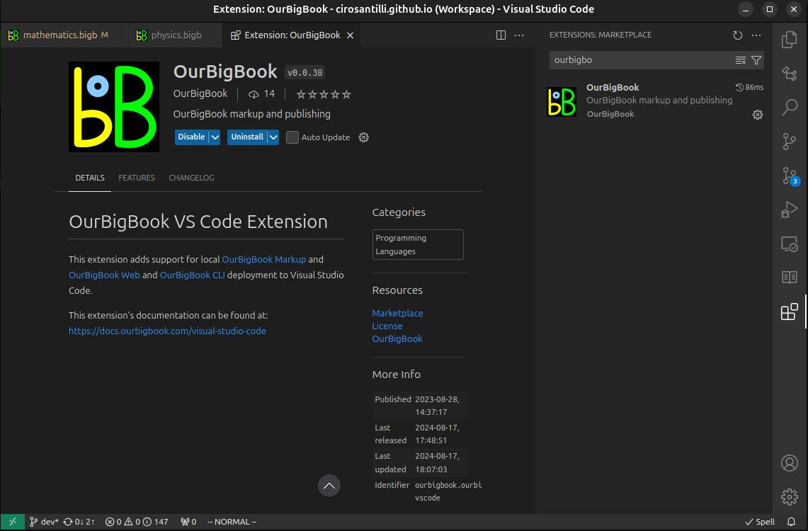
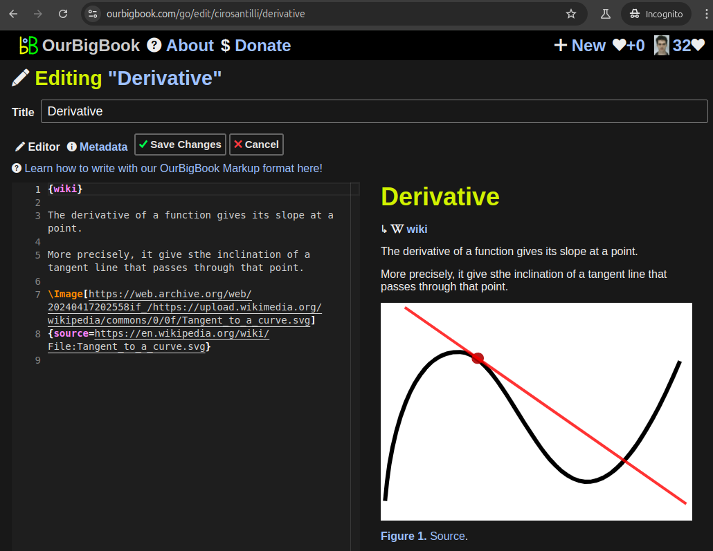
Figure 2. You can publish local OurBigBook lightweight markup files to either OurBigBook.com or as a static website.Figure 3. Visual Studio Code extension installation.Figure 5. . You can also edit articles on the Web editor without installing anything locally. Video 3. Edit locally and publish demo. Source. This shows editing OurBigBook Markup and publishing it using the Visual Studio Code extension. - Infinitely deep tables of contents:
All our software is open source and hosted at: github.com/ourbigbook/ourbigbook
Further documentation can be found at: docs.ourbigbook.com
Feel free to reach our to us for any help or suggestions: docs.ourbigbook.com/#contact


