A horizontal coordinate system describes a viewing direction using altitude above the observer's astronomical horizon and azimuth around it. Here azimuth starts at true north and increases through east: north is , east , south , and west , with . True north is the northward intersection of the celestial meridian with the astronomical horizon, rather than an uncorrected magnetic-compass reading. Other origins and directions are legitimate, but their formulae must be converted consistently. [ref]
https://www.astro.uvic.ca/~tatum/celmechs/celm6.pdf. Jeremy Tatum: Celestial mechanics, section 6.2, altazimuth coordinates and azimuth conventions
.Construct a local orthonormal basis of east , north , and upward , with . The upward unit vector points to the zenith; the horizontal plane is perpendicular to it. For a ground instrument, a freely hanging weight establishes the local vertical through gravity. In an elementary spherical-Earth model, this vertical is radial; precision work distinguishes it from the normal to a reference surface. With the observer as origin, write a direction's unit vector asIts local components obey . Conversely, and modulo one turn, except where . The quadrant-aware arctangent takes east as its first argument and north as its second. A synthetic direction with and has . Thus its horizontal component has norm ; its altitude is not the angle of the projected arrow in the horizontal plane.
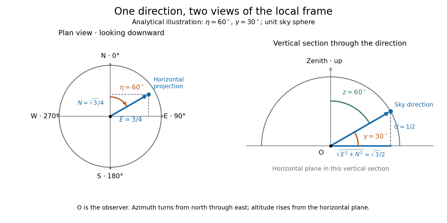
Analytical illustration of north-through-east azimuth and altitude in a local orthogonal frame; synthetic direction
. Details. A horizontal coordinate system depends on the observer's site and the observation time. The Earth's rotation changes the local axes relative to a fixed distant direction, while changing the site changes the zenith and the astronomical horizon. This makes the horizontal coordinate system directly useful for pointing an optical telescope and checking whether terrain blocks a target. A pair of angles without a site, time, azimuth convention, and geometric or refracted interpretation is an incomplete pointing instruction.
For a check against an equatorial coordinate system, let be the observer's geographical latitude, the direction's declination, and its west-positive hour angle, obtained from local sidereal time minus right ascension. In the spherical-Earth, unrefracted fixed-direction model, projection onto the local orthonormal basis givesTaking the dot product with the upward unit vector gives the last formula; the other two follow by the same projection. Recover altitude and azimuth from as above, using radians inside software trigonometric functions. The minus sign in is essential: a negative hour angle puts this synthetic direction east of the celestial meridian. [ref]
https://aa.usno.navy.mil/faq/alt_az. US Naval Observatory: Computing altitude and azimuth, local hour angle and quadrant-aware conversion
.For illustrative geographical latitude and invented declination , hour angle gives and . At , the same altitude accompanies : the direction is now westward. At , it is due south with altitude , agreeing with at upper meridian transit. These are analytical checks, not present positions of any star. For nearby objects, the direction must also be referred to the observer; simply rotating a geocentric direction omits the change of viewing position. Catalogue-to-observation refinements are described under equatorial coordinate system.
For a spherical Earth, geographical latitude is the angle of the local vertical above the equatorial plane. It equals the altitude of the north celestial pole in the northern hemisphere. Precision astrometry distinguishes geodetic and astronomical latitude.
Azimuth is the angle about the local vertical measured in the astronomical horizon. A common convention increases eastward from north; some astronomical formulae use westward from north. The convention changes the sign in the hour angle transformation.
Altitude , also called elevation angle, is the signed angle from the astronomical horizon to a viewing direction, measured in the vertical plane containing that direction and the zenith. Its range is : positive altitude is above the horizontal plane, zero altitude lies on the astronomical horizon, and points to the zenith. Altitude measures direction, rather than a Euclidean distance or a height in metres. In the local horizontal coordinate system, ; the dot product makes the sign unambiguous even for directions below the astronomical horizon.
A concrete motivating observation is the Exploratorium Teacher Institute's Height Sight activity. Its inclinometer uses a sighting tube fixed to a card and an angular scale, with a string and small weight hanging from the scale's pivot. A partner reads where the freely hanging string meets the scale. Sighting a level target should give a readout near zero; sighting a taller target gives an angular height. The activity asks the observer to move closer and farther: the closer position gives the larger angle. The interpretation is that the readout measures the tube's tilt relative to the gravity reference, while converting that angle to a physical height also requires distance and eye height. The activity also extends the inclinometer to sky observations. [ref]
https://www.exploratorium.edu/snacks/height-sight. Exploratorium Teacher Institute: Height Sight, construction, level check and distance-dependent angular observations
.The following calibration and sky sequence is a proposed extension, with no claimed observing dataset. First establish two reference marks at the same height with a water level, rather than assuming that a sloping floor or distant ridge is horizontal. Keep the inclinometer in a vertical plane, sight between the marks, wait for the weight to settle, and read the zero several times. Next sight a mark whose independently measured rise above the tube and horizontal separation are known; a right triangle predicts . A synthetic , gives . Checking both zero and this nonzero angle can reveal a wrongly attached tube or a scale read from the wrong end. Use level separation, not distance along inclined ground.
If the scale's indicated altitude is , estimate its additive zero from the level sight, then obtain apparent altitude . For synthetic readings and , the corrected altitude is , close to the calibration prediction. Declaring illustrative readout bounds of for each reading gives a conservative combined bound of on ; these bounds are assumptions, not measured performance. Repeatability tests the variation between readings, whereas a persistent zero offset remains a systematic measurement error. Include uncertainty in the reference rise and separation before judging agreement.
At a fixed site, sight a recognizable star, record the observation time, corrected altitude and north-through-east azimuth, and repeat over a short interval. Record the terrain boundary at the same azimuth separately from the gravity-defined zero. The fixed-direction model in horizontal coordinate system predicts changing angular readouts as the Earth rotates; this is a prospective test, rather than a fabricated measurement curve. Keep the tube aligned, the string free of contact and shielded from wind, the eye at the same reference position, and repeat the level check afterward. Timestamp each sight so genuine sky motion is not mistaken for poor repeatability. An optical telescope with an angular readout can replace the sighting tube, but its mounting still needs an independently established level and angular zero.
The corrected instrument reads apparent altitude, including atmospheric refraction. Under ordinary conditions atmospheric refraction raises a low direction, so if is the upward angular correction, . Subtracting the instrument zero does not subtract . Record site height, temperature and pressure if applying a refraction model: these are explicit observer inputs in the US Naval Observatory's NOVAS software. A coarse inclinometer may be unable to resolve the correction, and a local weather reading alone does not determine every atmospheric layer. [ref]
https://aa.usno.navy.mil/downloads/Circular_180C_C.pdf. US Naval Observatory: NOVAS C3.0 user's guide, observer inputs and equ2hor refraction options
.An inclinometer measures tilt relative to the vertical established by gravity, usually reporting an angle from the perpendicular horizontal plane. A weighted-string inclinometer compares a sighting tube with a freely hanging reference; its scale must be oriented so a level sight gives zero altitude. A raw protractor may instead indicate the complementary angle, so check the markings rather than assuming that every instrument has the same scale. [ref]
https://www.exploratorium.edu/snacks/height-sight. Exploratorium Teacher Institute: Height Sight, gravity reference and angular readout
.The zenith is the point on the celestial sphere in the direction of the observer's local upward vertical. In the horizontal coordinate system, its unit vector is and its altitude is . The zenith belongs to the observer's site; it is not generally the north celestial pole, whose altitude depends on geographical latitude. A direction's zenith distance is its nonnegative angle from the zenith, so . A direction of altitude therefore has zenith distance . [ref]
https://www.astro.uvic.ca/~tatum/celmechs/celm6.pdf. Jeremy Tatum: Celestial mechanics, section 6.2, zenith and complementary zenith distance
.At the zenith, every value of azimuth produces . There is no horizontal component to identify a bearing: cannot provide a geometrically meaningful azimuth, even if software returns a number. This coordinate singularity is a defect of the angular description; the viewing direction itself remains regular. The same ambiguity occurs at the opposite downward vertical. Near the zenith, two directions at fixed altitude separated by a small azimuth increment have separation to first order, with angles in radians. At altitude , a azimuth increment spans only about on that small arc. An optical telescope can consequently require a large bearing change for a small change of pointing near the zenith; working with unit vectors avoids inventing a preferred bearing at the singular point.
Zenith distance is the angle from the zenith to a viewing direction: , where is altitude and . The astronomical horizon has , while the zenith has . This unsigned separation supplies no azimuth and is distinct from the signed north/south angular readout used under declination.
The astronomical horizon is the great circle where the horizontal plane through the observer intersects the celestial sphere. It is perpendicular to the local vertical, so every direction on the astronomical horizon has altitude and zenith distance . In the local horizontal coordinate system, it consists of the unit vectors satisfying . This geometric reference remains defined when buildings or mountains hide it; a visible skyline is not a calibration of zero altitude.
Three boundaries must be distinguished. The astronomical horizon fixes the angular reference. Terrain supplies a site-dependent boundary with apparent altitude that changes with azimuth. Atmospheric refraction changes the apparent direction of incoming light, and can also change the apparent distant boundary. A point source clears an opaque terrain boundary only if when both are expressed in the same apparent horizontal coordinate system; this clearance condition does not guarantee visibility through clouds or bright sky. In the synthetic diagram, a source with geometric altitude and an imposed illustrative upward correction remains behind a boundary. The chosen is an algebraic illustration, not a fitted atmospheric prediction.
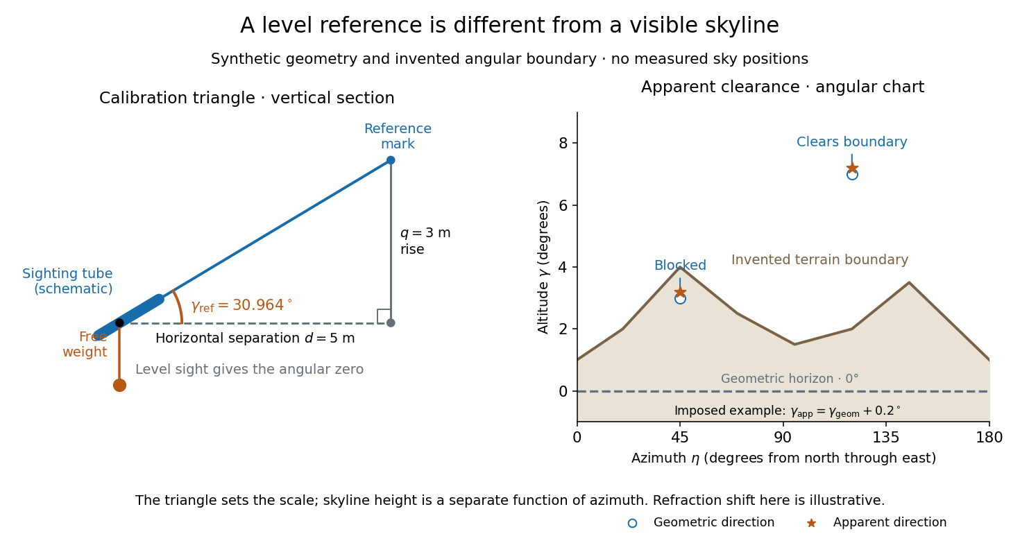
Synthetic calibration triangle and invented terrain boundary; angular zero, apparent altitude and geometric horizon are separate
. Details. Even an unobstructed sea boundary need not coincide with the astronomical horizon. On a spherical Earth of radius , an observer at height sees the unrefracted tangent to the surface at a downward angle satisfying . The right-angle tangent triangle supplies this relation; the visible boundary then has altitude . With illustrative and , , before atmospheric refraction. Raising the eye therefore changes the visible boundary without redefining the horizontal plane.
The US Naval Observatory's rise/set definitions explicitly distinguish the geometric reference from apparent contact with a visible disk: the standard Sun calculation puts its centre below the horizontal plane, combining an average radius with of atmospheric refraction. An angular minute is in the minute and second of arc convention. This is an operational average under stated conditions, rather than a universal zero of altitude. The same source identifies weather, local topography and observer height as limits on predicted rise/set time. An observation log should therefore retain the level reference, site and eye height, terrain profile, observation time, and whether each reported altitude is geometric or apparent. [ref]
https://aa.usno.navy.mil/faq/RST_defs. US Naval Observatory: Rise, set and twilight definitions, geometric horizon and observational limitations
. Articles by others on the same topic



The Horizontal Coordinate System, also known as the Altitude/Azimuth Coordinate System, is a locally defined system used in astronomy to specify the position of celestial objects in the sky as viewed from a particular location on Earth at a specific time. ### Key Components: 1. **Altitude (Alt)**: - The angle measured from the observer's local horizon to the object in the sky.