The term "strong partition cardinal" doesn't appear to be widely recognized in the fields of mathematics or computer science as of my last knowledge update in October 2023. It might refer to a concept in a specific area of research or a niche topic that has emerged more recently. In the context of partitions in mathematics, a partition typically refers to a way of writing a number or set as a sum of positive integers, or dividing a set into subsets.
Dennis Rodman is a former professional basketball player known for his unique playing style, defensive prowess, and vibrant personality. Here’s a list of some of his notable career achievements: 1. **NBA Championships**: Rodman won a total of 5 NBA championships. He won two championships with the Detroit Pistons in 1989 and 1990, and three with the Chicago Bulls in 1996, 1997, and 1998.
Franc Hočevar may refer to a specific individual, but there aren’t any widely recognized figures or concepts associated with that name in public knowledge as of my last update in October 2023. It's possible that he could be a private individual, a local figure, or someone relevant in a certain context or region.
Cartography, the art and science of map-making, varies across different continents due to differences in geography, cultural significance, and historical contexts. Here’s an overview of cartography by continent: ### North America - **Historical Context**: Early maps were created by Indigenous peoples, often focusing on natural landmarks and travel routes. European explorers later charted the continent, leading to significant but often Eurocentric maps.
Cave surveying, also known as cave mapping or speleometry, is the process of measuring and documenting the geometry and features of a cave system. This involves gathering data about the cave's size, shape, and layout, as well as its geological features, passage configurations, and any notable formations such as stalactites, stalagmites, and pools.
The history of cartography is the study of the creation and use of maps throughout human history. It reflects the development of human understanding of geography, technology, and society. Here’s an overview of key periods and milestones in the history of cartography: ### Ancient Mapmaking - **Prehistoric Maps:** Early human societies created rudimentary maps (e.g., cave drawings) to depict their surroundings and hunting territories.
In cartography, a cartouche is a decorative motif used to enclose a map's title, scale, legend, or other important information. It is often ornately designed, giving maps an artistic touch while also helping to highlight key textual information. The term "cartouche" originally comes from the French word for a scroll or a roll of paper, and it is sometimes associated with a frame that resembles an elongated oval or a shield shape.
D. R. Fraser Taylor is a prominent Canadian geographer and a recognized authority in the field of Geographic Information Systems (GIS), cartography, and digital mapping. He is known for his work in developing techniques and methodologies for spatial data analysis and visualization. Taylor has been involved in various academic and research endeavors, contributing to the understanding of geographical information science and its applications across different disciplines.
MacChoro is a Japanese music game application that combines elements of rhythm and puzzle gameplay. It encourages players to tap along to rhythm patterns, usually involving colorful visuals and catchy music. The game typically involves matching taps or swipes on the screen to the beat of the music. Players often have to navigate through increasingly complex levels, which can include various challenges and obstacles.
The Maximum Elevation Figure (MEF) is a term used in aviation to refer to the highest elevation, in feet or meters, of terrain, obstacles, or other features in a particular area, taking into account a specified vertical clearance. This figure is typically used in aviation charts, especially in the context of en route navigation and obstacle clearance. The MEF is important for pilots to ensure safe flight operations by providing information about the tallest structures and terrain in the vicinity.
The Hermes Road Measurement System is a technology designed for measuring various parameters of road surfaces to assess their condition and performance. It typically involves the use of sensors and data acquisition systems mounted on vehicles that travel along roads to collect information about surface conditions, roughness, texture, and other factors that influence road quality and safety.
Isoazimuth refers to a line or a surface on a map or a diagram that indicates points sharing the same azimuth angle relative to a specific reference point or direction. In cartography and navigation, azimuth is the angle measured clockwise from a reference direction, typically true north, to the line connecting the observer to a point of interest.
As of my last knowledge update in October 2021, there isn't any widely recognized figure, concept, or topic known as "Jacques Feldbau." It's possible that Jacques Feldbau could refer to a specific individual who may not be well-known in public discourse, or it might relate to developments or events that have emerged after my last update.
An opisometer is a measuring instrument used to measure lengths or distances along curved paths. It typically consists of a wheel that rolls along the surface of the curve, and the distance is read off a scale or display. Opisometers are often used in fields such as cartography, engineering, and surveying to measure irregular or curved lines, such as those found on maps or in diagrams. They can be mechanical or digital, with the latter providing more precise readings.
Planimetrics refers to the representation of two-dimensional spatial data, typically focusing on the horizontal layout of features and landforms on a plane. It involves the use of maps and diagrams to portray the location and arrangement of various physical features, such as buildings, roads, vegetation, and bodies of water, without considering elevation or height.
Rome2Rio is a travel planning platform that helps users find the best routes and transportation options between destinations. Launched in 2010, it aggregates various modes of transportation, including flights, trains, buses, ferries, and driving directions, allowing users to compare different travel options based on time, cost, and convenience. The website and mobile app provide users with detailed information about schedules, ticket prices, and connections, making it a valuable resource for travelers looking to plan their journeys efficiently.
A stereoautograph is a specialized device used primarily in the field of stereo photography and 3D imaging. It typically refers to a machine or system that can create stereo images, which provide a sense of depth by displaying two slightly different perspectives of the same scene, mimicking the way human eyes perceive depth.
Typometry, specifically in the context of printing, refers to the measurement and arrangement of type characters in graphic design and typography. It encompasses various aspects of type design, including the size, weight, spacing, and alignment of fonts and characters used in printed materials. Key components of typometry include: 1. **Point Size**: The height of the typeface, which affects readability and aesthetics.
Pinned article: Introduction to the OurBigBook Project
Welcome to the OurBigBook Project! Our goal is to create the perfect publishing platform for STEM subjects, and get university-level students to write the best free STEM tutorials ever.
Everyone is welcome to create an account and play with the site: ourbigbook.com/go/register. We belive that students themselves can write amazing tutorials, but teachers are welcome too. You can write about anything you want, it doesn't have to be STEM or even educational. Silly test content is very welcome and you won't be penalized in any way. Just keep it legal!
Intro to OurBigBook
. Source. We have two killer features:
- topics: topics group articles by different users with the same title, e.g. here is the topic for the "Fundamental Theorem of Calculus" ourbigbook.com/go/topic/fundamental-theorem-of-calculusArticles of different users are sorted by upvote within each article page. This feature is a bit like:
- a Wikipedia where each user can have their own version of each article
- a Q&A website like Stack Overflow, where multiple people can give their views on a given topic, and the best ones are sorted by upvote. Except you don't need to wait for someone to ask first, and any topic goes, no matter how narrow or broad
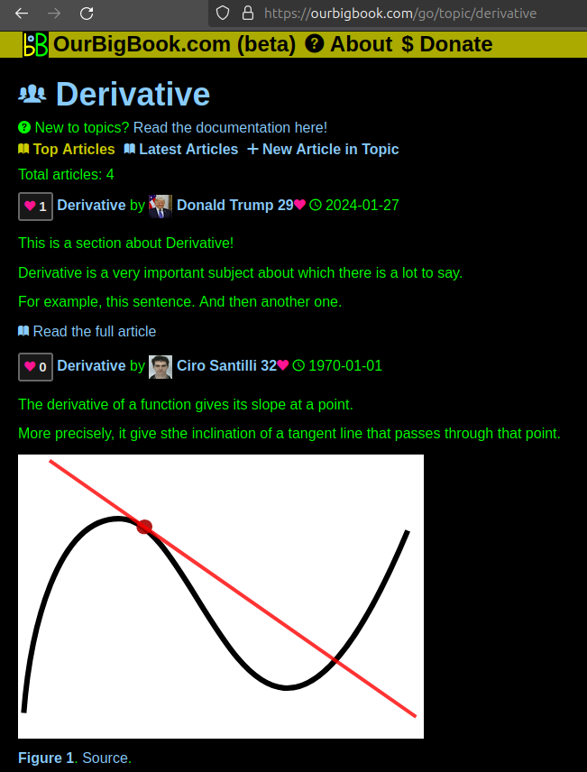
This feature makes it possible for readers to find better explanations of any topic created by other writers. And it allows writers to create an explanation in a place that readers might actually find it.Figure 1. Screenshot of the "Derivative" topic page. View it live at: ourbigbook.com/go/topic/derivativeVideo 2. OurBigBook Web topics demo. Source. - local editing: you can store all your personal knowledge base content locally in a plaintext markup format that can be edited locally and published either:This way you can be sure that even if OurBigBook.com were to go down one day (which we have no plans to do as it is quite cheap to host!), your content will still be perfectly readable as a static site.
- to OurBigBook.com to get awesome multi-user features like topics and likes
- as HTML files to a static website, which you can host yourself for free on many external providers like GitHub Pages, and remain in full control
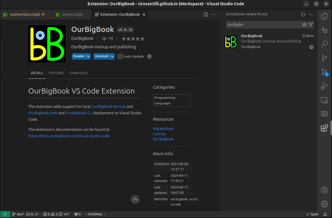
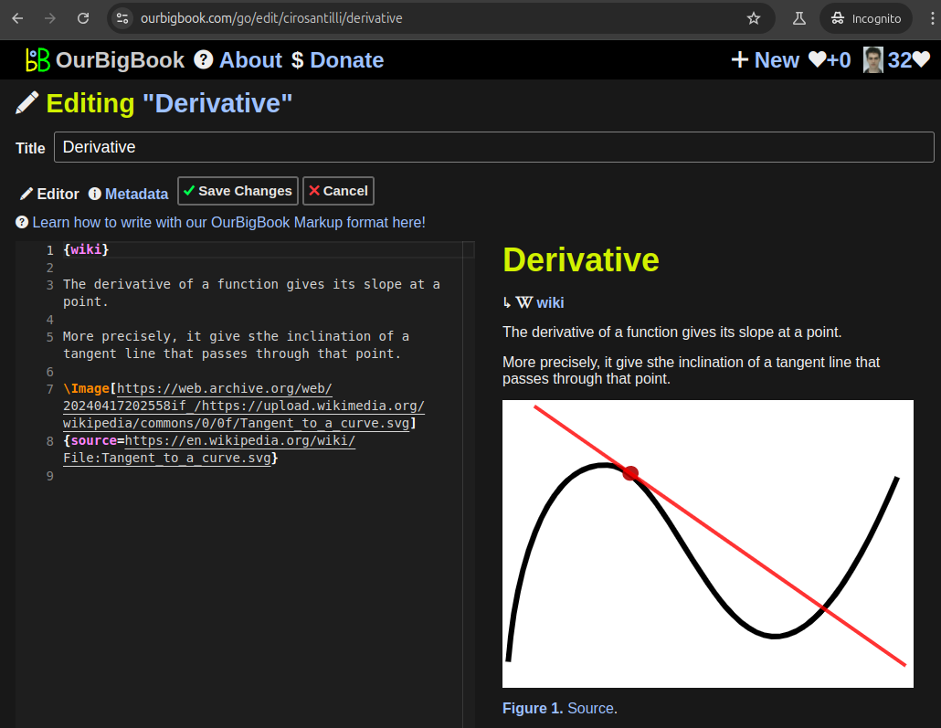
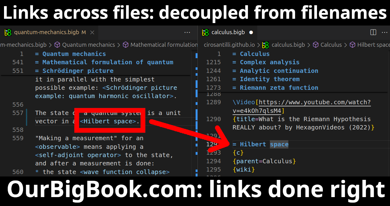
Figure 3. Visual Studio Code extension installation.Figure 4. Visual Studio Code extension tree navigation.Figure 5. Web editor. You can also edit articles on the Web editor without installing anything locally.Video 3. Edit locally and publish demo. Source. This shows editing OurBigBook Markup and publishing it using the Visual Studio Code extension.Video 4. OurBigBook Visual Studio Code extension editing and navigation demo. Source. - Infinitely deep tables of contents:
All our software is open source and hosted at: github.com/ourbigbook/ourbigbook
Further documentation can be found at: docs.ourbigbook.com
Feel free to reach our to us for any help or suggestions: docs.ourbigbook.com/#contact


