"Double fold" can refer to a few different concepts depending on the context. Here are a few possibilities: 1. **Textiles and Fabrics**: In sewing or fabric crafting, "double fold" typically refers to a method of finishing the edge of the fabric where the raw edge is folded over twice. This technique helps prevent fraying and gives a neater appearance.
A Doubly Connected Edge List (DCEL) is a data structure used to represent a planar graph, especially in computational geometry. It provides a way to efficiently store and manipulate the relationships between edges, vertices, and faces of a planar graph. ### Components of a DCEL A DCEL typically consists of the following components: 1. **Edge**: Each edge in the DCEL contains: - A reference to its starting vertex.
Doug Lea is a prominent computer scientist known for his contributions to the field of concurrent programming and software engineering. He is a professor at the State University of New York at Oswego and is particularly recognized for his work on the design and implementation of Java's concurrency utilities. One of his most notable contributions is the development of the `java.util.concurrent` package, which provides a set of synchronization and concurrency utilities to support multithreaded programming in Java.
DSS, or 2,2-Dimethyl-2-silapentane-5-sulfonic acid, is a chemical compound commonly used as a reference standard in nuclear magnetic resonance (NMR) spectroscopy, particularly in the field of organic chemistry and biochemistry. DSS is particularly valuable because it is soluble in water and organic solvents, making it suitable for a wide range of applications.
The Dover Strait coastal guns refer to a series of coastal artillery installations located along the cliffs and shores of the Dover Strait, which separates England from mainland Europe. These guns were primarily used during World War II to protect against potential naval invasions and to secure the Strait, which is a critical shipping lane and a strategic military passage. Historically, the coastal defenses included large-caliber naval guns installed on both the British and French sides of the Strait.
Dovetail rail is a type of structural element often used in various construction and manufacturing applications, particularly in the context of rail systems and sliding mechanisms. The term "dovetail" refers to a specific joint design that resembles the shape of a dove's tail, which provides a strong and stable connection between two elements.
"Drift plus penalty" typically refers to a concept found in fields like machine learning, statistics, or control systems, particularly when addressing the robustness and performance of algorithms in varying conditions. Here's a breakdown of the components of this concept: 1. **Drift**: In statistical terms, "drift" often refers to the gradual change in a system or process over time, which can lead to performance degradation if not accounted for.
The Dr. Neil Trivett Global Atmosphere Watch Observatory is associated with the Global Atmosphere Watch (GAW) program, which is managed by the World Meteorological Organization (WMO). GAW aims to provide long-term, high-quality observations of the atmosphere and its constituents to better understand atmospheric processes and changes, particularly those related to climate change and air quality. The observatory is named in honor of Dr.
The shortest path problem is a fundamental problem in graph theory and computer science that involves finding the shortest path or minimum distance between two nodes (vertices) in a graph. Graphs can be directed or undirected, weighted or unweighted, and the shortest path can be defined in terms of the smallest sum of weights of the edges traversed.
Dry lubricants are substances applied to reduce friction between surfaces in contact without the use of liquid lubricants like oils or greases. They typically come in the form of powders or solid films and work by providing a low-friction interface between sliding surfaces. Some common types of dry lubricants include: 1. **Graphite**: A form of carbon that is known for its excellent lubricating properties, especially at high temperatures.
Nasreddin in Bukhara refers to the legendary character Nasreddin Hodja, a popular figure in Middle Eastern and Central Asian folklore. In this context, Bukhara, a historic city in Uzbekistan, is one of the many places where stories and anecdotes about Nasreddin are shared and celebrated. Nasreddin is often depicted as a wise fool or a sage who uses humor and wit to impart lessons and offer commentary on human nature and societal issues.
Dual X-ray Absorptiometry (DXA or DEXA) is a medical imaging technique primarily used to measure bone mineral density (BMD). It employs two X-ray beams with different energy levels to assess the amount of bone in a specific area, typically the spine, hip, or wrist. DXA is widely regarded as a standard method for diagnosing osteoporosis and determining fracture risk, as well as for monitoring bone density changes over time, especially in patients undergoing treatment for bone-related conditions.
Duration Calculus (DC) is a formal mathematical framework used for specifying and reasoning about the timing and duration of events in real-time systems. It is particularly useful in the fields of computer science, especially in the design and analysis of real-time systems, where timing constraints are crucial. Introduced by K. J. C. (Kim) V. A.
A Radioisotope Piezoelectric Generator (RPEG) is a type of power generation device that combines principles from both radioisotope thermoelectric generators (RTGs) and piezoelectric technology. The main components and their functions can be outlined as follows: 1. **Radioisotope Source**: The generator uses a radioisotope, commonly radioactive isotopes like cesium-137 or strontium-90, which emits radiation as it decays. This radioactive decay generates heat.
A Denso mapcode is a location-based identifier used primarily in Japan to facilitate navigation and mapping. It is a numeric code that corresponds to a specific geographic area and can be used to pinpoint locations on maps, making it easier for users to find destinations without needing traditional addresses. The Denso mapcode system is particularly popular for use in vehicles equipped with GPS navigation systems, as it allows drivers to input these codes for quick access to directions.
As of my last knowledge update in October 2023, there isn't widely available information on an individual named Ebadollah S. Mahmoodian in prominent public databases or within notable news sources. He might be a professional or academic figure in a specific field that hasn't received widespread recognition or coverage in global media.
The Dynamical Theory of Diffraction is a theoretical framework used to understand the scattering of waves, particularly X-rays and electrons, by crystalline materials. It provides a more comprehensive picture than the earlier kinematic theories, as it takes into account the multiple scattering effects that occur when waves interact with a periodic structure, such as a crystal lattice. ### Key Concepts: 1. **Wave Interaction with Crystals**: When waves interact with a periodic structure, they can be diffracted in various directions.
Earle Hesse Kennard was an American artist, art historian, and educator known for his contributions to the field of art education and his work in various artistic mediums. However, detailed and specific information about him may be limited or not well-documented.
Pinned article: Introduction to the OurBigBook Project
Welcome to the OurBigBook Project! Our goal is to create the perfect publishing platform for STEM subjects, and get university-level students to write the best free STEM tutorials ever.
Everyone is welcome to create an account and play with the site: ourbigbook.com/go/register. We belive that students themselves can write amazing tutorials, but teachers are welcome too. You can write about anything you want, it doesn't have to be STEM or even educational. Silly test content is very welcome and you won't be penalized in any way. Just keep it legal!
Intro to OurBigBook
. Source. We have two killer features:
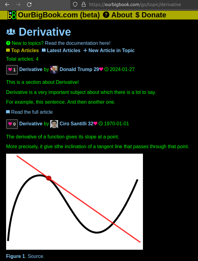
- topics: topics group articles by different users with the same title, e.g. here is the topic for the "Fundamental Theorem of Calculus" ourbigbook.com/go/topic/fundamental-theorem-of-calculusArticles of different users are sorted by upvote within each article page. This feature is a bit like:
- a Wikipedia where each user can have their own version of each article
- a Q&A website like Stack Overflow, where multiple people can give their views on a given topic, and the best ones are sorted by upvote. Except you don't need to wait for someone to ask first, and any topic goes, no matter how narrow or broad
This feature makes it possible for readers to find better explanations of any topic created by other writers. And it allows writers to create an explanation in a place that readers might actually find it.Figure 1. Screenshot of the "Derivative" topic page. View it live at: ourbigbook.com/go/topic/derivativeVideo 2. OurBigBook Web topics demo. Source. - local editing: you can store all your personal knowledge base content locally in a plaintext markup format that can be edited locally and published either:This way you can be sure that even if OurBigBook.com were to go down one day (which we have no plans to do as it is quite cheap to host!), your content will still be perfectly readable as a static site.
- to OurBigBook.com to get awesome multi-user features like topics and likes
- as HTML files to a static website, which you can host yourself for free on many external providers like GitHub Pages, and remain in full control
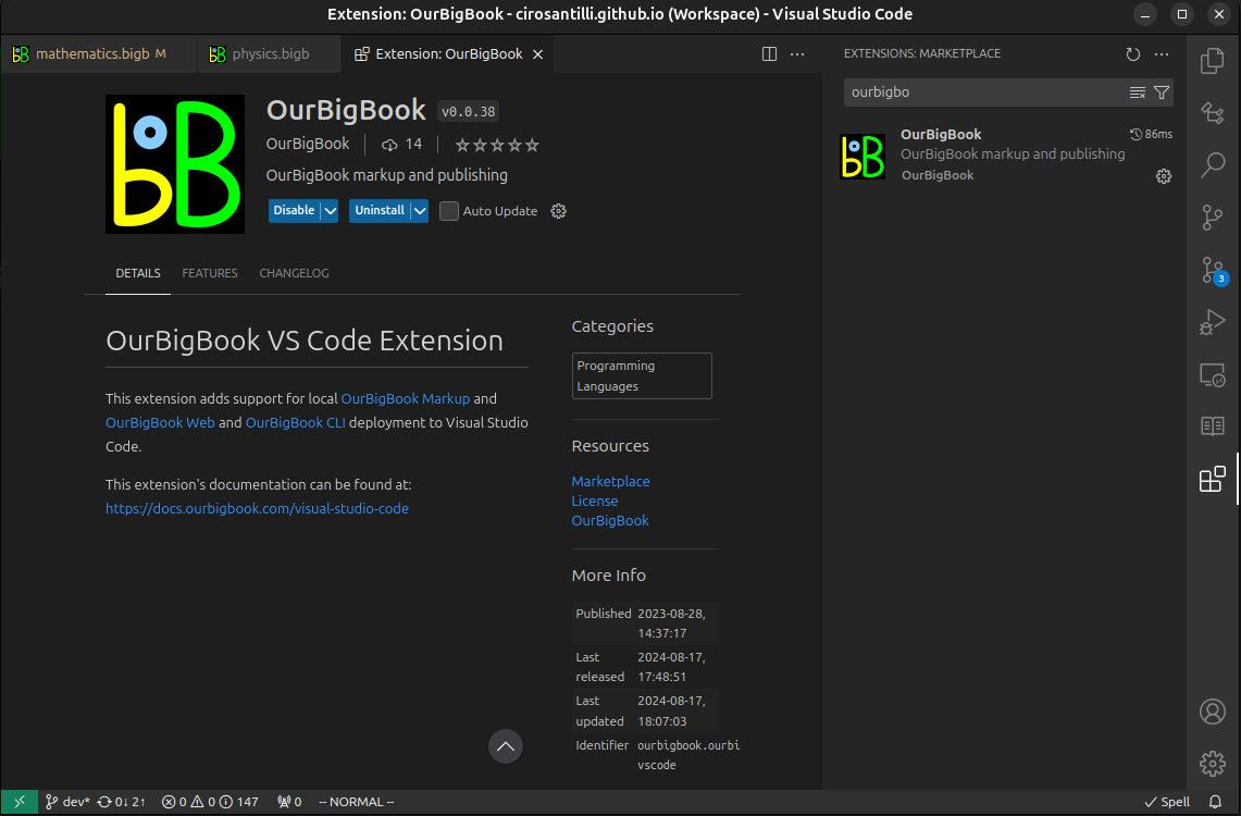
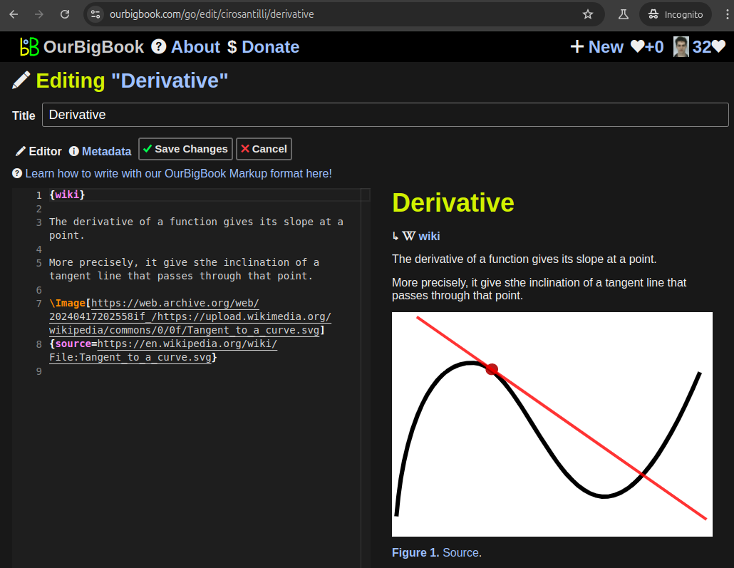
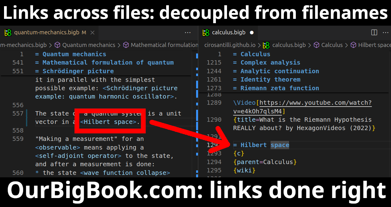
Figure 3. Visual Studio Code extension installation.Figure 4. Visual Studio Code extension tree navigation.Figure 5. Web editor. You can also edit articles on the Web editor without installing anything locally.Video 3. Edit locally and publish demo. Source. This shows editing OurBigBook Markup and publishing it using the Visual Studio Code extension.Video 4. OurBigBook Visual Studio Code extension editing and navigation demo. Source. - Infinitely deep tables of contents:
All our software is open source and hosted at: github.com/ourbigbook/ourbigbook
Further documentation can be found at: docs.ourbigbook.com
Feel free to reach our to us for any help or suggestions: docs.ourbigbook.com/#contact


