X.1035 is a standard published by the International Telecommunication Union (ITU) as part of the X.1000 series of recommendations. This standard pertains specifically to an approach for the management of electronic documents. More specifically, X.1035 provides guidelines and frameworks for the use of metadata for managing documents in a way that ensures better interoperability, accessibility, and management within electronic document systems. In the context of information technology and telecommunications, standards like X.
WikiLeaks is a non-profit organization that was founded in 2006 by Australian activist Julian Assange and others. It is known for publishing classified, leaked, and sensitive documents from anonymous sources with the aim of promoting transparency and accountability in government and institutions. WikiLeaks gained significant international attention for its publication of various high-profile documents, including U.S. diplomatic cables, military documents related to the wars in Iraq and Afghanistan, and emails from political organizations.
A Physical Unclonable Function (PUF) is a hardware-based security technology that exploits the inherent physical variations in the manufacturing process of integrated circuits. These variations create unique and unpredictable characteristics in each individual chip, which can be used to generate a unique digital fingerprint or identifier for that chip.
Multilingualism is the ability of an individual or the capacity of a community to use and understand multiple languages. It encompasses a wide range of language skills, from being fluent in several languages to having basic conversational abilities in others. Multilingualism can occur at different levels, including: 1. **Individual Multilingualism**: This refers to a person's proficiency in two or more languages.
Translation studies is an interdisciplinary field that focuses on the study of translation, interpreting, and related practices. It examines the processes, strategies, theories, and cultural contexts involved in translating texts from one language to another. Translation studies encompass various aspects, including: 1. **Theoretical Frameworks**: Scholars explore various theories of translation, such as equivalence, skopos theory (purpose-oriented), and dynamic vs. formal equivalence, among others.
Corpus linguistics is the study of language as expressed in samples (or corpora) of real-world text. It involves the analysis of large collections of written or spoken texts (corpora) using computational tools and methods. The primary aim is to understand linguistic phenomena by examining how words, phrases, sentences, and larger structures are used in context across different genres, registers, and discourse types.
A Corpus Manager typically refers to a software tool or system used for the organization, management, and analysis of a corpus, which is a substantial collection of texts or linguistic data. Corpus management is crucial in fields such as computational linguistics, natural language processing, and digital humanities. Key features of a Corpus Manager may include: 1. **Data Organization**: The ability to store and categorize texts based on various attributes such as genre, author, or publication date.
The Corpus of Contemporary American English (COCA) is a large, structured database of text that captures a wide range of contemporary American English usage. Compiled by linguist Mark Davies, COCA includes over 1 billion words of text collected from various sources, such as spoken language, fiction, magazines, newspapers, and academic texts.
Open discourse generally refers to a mode of communication that encourages free and open expression of ideas, opinions, and perspectives. It is characterized by inclusivity, transparency, and a willingness to engage in respectful dialogue across various viewpoints. Open discourse can be seen in different contexts, including academic settings, public discussions, online forums, and community dialogues.
Oral myology is a specialized area of study and practice that focuses on the muscles and function of the oral and facial structures, particularly in relation to speech, swallowing, and overall oral function. It examines how the muscles of the mouth, face, and neck work together to facilitate these processes and can address issues related to oral motor skills, as well as the impact of tongue posture and oral habits on the development and function of the oral cavity.
The Hamshahri Corpus is a large-scale Persian text dataset that was created to support natural language processing (NLP) research and applications, particularly for the Persian language. It consists of a collection of newspaper articles that were published by the Hamshahri newspaper in Iran.
The International Speech Communication Association (ISCA) is a professional organization dedicated to promoting the science and technology of speech communication and related disciplines. Founded in 1990, ISCA serves as a platform for researchers, practitioners, and educators to collaborate, share knowledge, and advance the field of speech communication. ISCA organizes conferences and workshops, such as the annual Interspeech conference, which is one of the largest and most significant events in the field of speech processing and speech technology.
Interruption in speech refers to the act of breaking into a conversation by speaking over someone else or cutting them off before they have finished their thought. This phenomenon can happen in various contexts, such as casual conversations, formal discussions, or debates. Interruptions can serve different purposes, including: 1. **Clarification**: Sometimes a listener may interrupt to ask for clarification or to ensure they understood the preceding information correctly.
The Survey of English Usage is a research project that focuses on the analysis and documentation of contemporary English language usage. It typically involves systematic examination of how English is used in various contexts, such as in written texts and spoken conversation. The primary aim is to gather evidence about language patterns, variations, and changes over time, often focusing on aspects like grammar, vocabulary, and usage norms.
"Vorlage" is a German word that translates to "template" or "model" in English. Depending on the context, it can refer to different concepts: 1. **In General Use**: It can refer to any kind of template or outline used as a guide for creating documents, designs, or other works. 2. **In Education**: "Vorlage" might refer to an instructional template or a model used in educational settings to help students understand and create their work.
Language analysis for the determination of origin, often referred to as "linguistic profiling," involves examining various linguistic features of a person's speech or writing to infer their geographic, social, or cultural background. This method can be used in various fields, including forensic linguistics, immigration assessments, and sociolinguistics.
Linguistic distance refers to the degree of difference between languages or dialects based on various linguistic features. These features can include phonetics (sounds), vocabulary (lexicon), grammar (syntax and morphology), and semantics (meaning). Linguistic distance can be measured in several ways: 1. **Lexical Distance**: This examines the number of words that are similar or identical in two languages. It often involves evaluating cognates—words that have a common etymological origin.
The Neo-Assyrian Text Corpus Project (NATCP) is an academic initiative that focuses on the compilation, publication, and analysis of texts from the Neo-Assyrian Empire, which flourished from approximately 911 to 612 BCE in the ancient Near East. The project aims to create a comprehensive digital database of Neo-Assyrian texts, including administrative documents, literary works, religious texts, and inscriptions.
NNEST stands for Non-Native English Speaker Teacher. It is a term used in the field of language education to refer to teachers whose first language is not English but who teach English, often in settings where English is a second or foreign language. NNESTs can bring unique perspectives and insights into language teaching, and their experiences can enrich the learning environment for students.
Linguistics is the scientific study of language and its structure. It encompasses a wide range of topics and subfields. Below is an outline of key areas within linguistics: ### 1. **Phonetics** - Study of the physical sounds of human speech. - **Articulatory Phonetics**: How speech sounds are produced. - **Acoustic Phonetics**: The properties of sound waves produced during speech.
Pinned article: Introduction to the OurBigBook Project
Welcome to the OurBigBook Project! Our goal is to create the perfect publishing platform for STEM subjects, and get university-level students to write the best free STEM tutorials ever.
Everyone is welcome to create an account and play with the site: ourbigbook.com/go/register. We belive that students themselves can write amazing tutorials, but teachers are welcome too. You can write about anything you want, it doesn't have to be STEM or even educational. Silly test content is very welcome and you won't be penalized in any way. Just keep it legal!
Intro to OurBigBook
. Source. We have two killer features:
- topics: topics group articles by different users with the same title, e.g. here is the topic for the "Fundamental Theorem of Calculus" ourbigbook.com/go/topic/fundamental-theorem-of-calculusArticles of different users are sorted by upvote within each article page. This feature is a bit like:
- a Wikipedia where each user can have their own version of each article
- a Q&A website like Stack Overflow, where multiple people can give their views on a given topic, and the best ones are sorted by upvote. Except you don't need to wait for someone to ask first, and any topic goes, no matter how narrow or broad
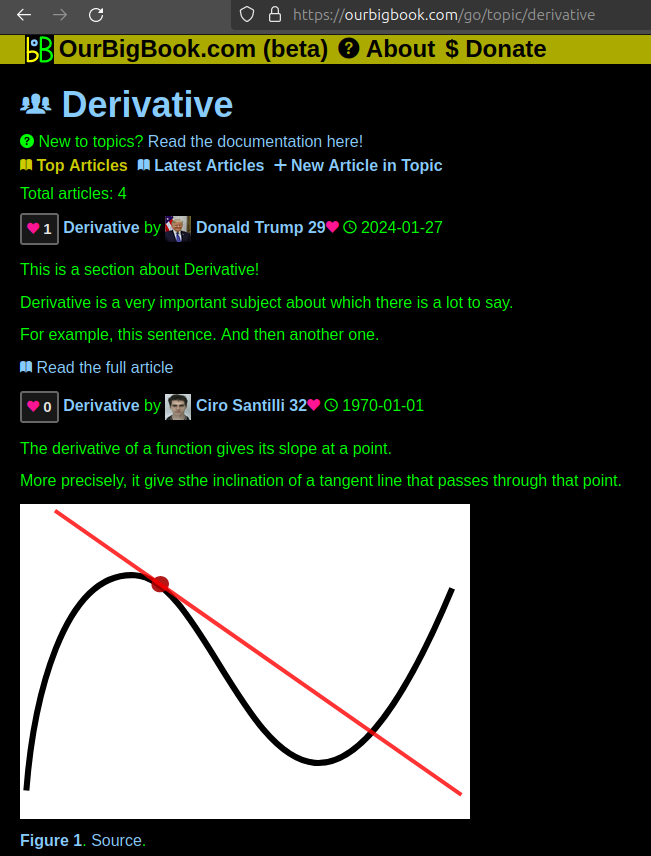
This feature makes it possible for readers to find better explanations of any topic created by other writers. And it allows writers to create an explanation in a place that readers might actually find it.Figure 1. Screenshot of the "Derivative" topic page. View it live at: ourbigbook.com/go/topic/derivativeVideo 2. OurBigBook Web topics demo. Source. - local editing: you can store all your personal knowledge base content locally in a plaintext markup format that can be edited locally and published either:This way you can be sure that even if OurBigBook.com were to go down one day (which we have no plans to do as it is quite cheap to host!), your content will still be perfectly readable as a static site.
- to OurBigBook.com to get awesome multi-user features like topics and likes
- as HTML files to a static website, which you can host yourself for free on many external providers like GitHub Pages, and remain in full control
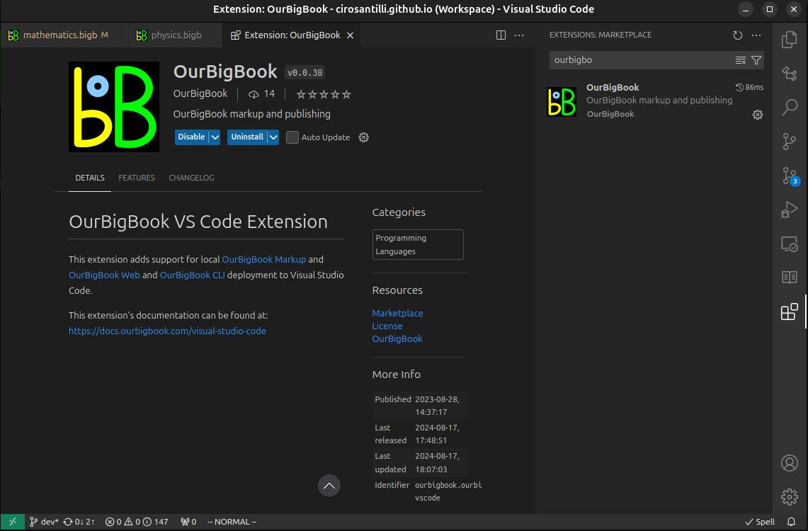
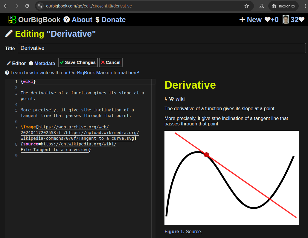
Figure 3. Visual Studio Code extension installation.Figure 4. Visual Studio Code extension tree navigation.Figure 5. Web editor. You can also edit articles on the Web editor without installing anything locally.Video 3. Edit locally and publish demo. Source. This shows editing OurBigBook Markup and publishing it using the Visual Studio Code extension.Video 4. OurBigBook Visual Studio Code extension editing and navigation demo. Source. - Infinitely deep tables of contents:
All our software is open source and hosted at: github.com/ourbigbook/ourbigbook
Further documentation can be found at: docs.ourbigbook.com
Feel free to reach our to us for any help or suggestions: docs.ourbigbook.com/#contact


