
Vacuum prescription for inflationary in-in integrals Created 2026-10-06 Updated 2026-10-14
The Gaussian Bunch-Davies vacuum is selected by tilting the early endpoint to for integrands with . They then decay at the early boundary. The complex-conjugate integrand requires the opposite tilt. Ordered contractions and their contour must be conjugated together.
In-in bispectrum conjugation rule Created 2026-10-06 Updated 2026-10-14
Unsharp masking 2026-10-06
Subtract a smoothed image signal and add a scaled residual: . The Fourier multiplier is bounded by . This enhances apparent contrast but also amplifies noise; it is not a stable exact inverse of heat image smoothing.
Shock filter for image enhancement 2026-10-06
The formal shock-filter equation steepens transitions around inflection boundaries. It is a Hamilton–Jacobi-type transport mechanism rather than positive diffusion. Combining it with controlled forward image smoothing limits noise amplification.
Beltrami-Klein model Created 2026-10-06 Updated 2026-10-07
The Beltrami-Klein model realizes the hyperbolic plane inside an open Euclidean disk, with geodesics given by straight chords. Its metric differs from the Euclidean metric, and angles are generally distorted. The straight chords make geodesic convexity especially easy to see.
Absolute hydrodynamic instability 2026-10-06
An absolute hydrodynamic instability makes the response to a localized impulse grow at a fixed spatial point in a specified frame. This differs from convective hydrodynamic instability, which amplifies a moving wave packet while its response decays at fixed positions. For analytic dispersion relations, the relevant absolute frequency is associated with an accessible zero-group velocity saddle, with the spatial-branch selection checked rather than assumed for an arbitrary dispersion relation.
Convective hydrodynamic instability 2026-10-06
A convective hydrodynamic instability amplifies an advected localized disturbance while its amplitude decays at any fixed position. The distinction from absolute hydrodynamic instability depends on the observation frame.
Saddle growth rate along a ray 2026-10-06
On a ray , a localized wave packet is governed by a physically selected saddle point satisfying in its analytic dispersion relation. The exponent's real growth is . The fixed-frame case gives the absolute growth rate. This ray formulation makes the frame dependence of convective hydrodynamic instability explicit.
For the linear complex Ginzburg-Landau equation with real and positive real diffusion coefficient scaled to one, the maximum temporal growth rate is and the absolute growth rate is . For , is stable, has convective hydrodynamic instability, and has absolute hydrodynamic instability. Both equality boundaries are marginal in exponential rate.
Kinetic-energy inner product 2026-10-06
For a constant reference density, fluid perturbation kinetic energy is proportional to under the displayed inner product. An adjoint operator for perturbation evolution must be defined relative to this inner product, including boundary conditions and the projection onto incompressible flow.
For an incompressible parallel flow with base velocity and perturbation proportional to , divergence of the linearized momentum equations gives . At a no-slip boundary condition, streamwise momentum gives . The equation encodes how base shear generates perturbation fluid pressure.
Three-layer long-wave shear-flow matching 2026-10-06
A high-Reynolds number long-wave mode near a wall has a viscous layer of thickness , an order-one region following the base profile, and a pressure-decay region of thickness . The lower Airy function solution fixes velocity displacement and fluid pressure. The middle Rayleigh equation for inviscid shear flow transports these to the outer constant-velocity region. Matching its decaying pressure produces an Airy wall-layer matching determinant. For order-one amplitudes, constant leading middle pressure requires ; the distinguished balance gives .
Baroclinic instability 2026-10-06
Baroclinic instability converts potential energy of a stratified sheared basic flow into growing disturbances. In the Eady model, coupled Boundary Rossby waves provide a useful mechanism: their induced velocities displace boundary buoyancy anomalies, and suitable wavelengths permit phase locking. A single neutral boundary wave does not by itself imply exponential instability.
Critical level of a shear-flow wave 2026-10-06
For a wave with zonal phase velocity in a basic shear , a critical level is a height at which . The Doppler-shifted material frequency then vanishes. This means equality of the laboratory velocities; the and terms cancel in the wave frame. It does not mean . A semi-infinite Eady edge wave with zero interior potential vorticity anomaly can remain regular through its steering height.
Critical layer in a shear flow Created 2026-10-06 Updated 2026-10-14
A critical layer is a region where the leading wave phase speed coincides with the local shear-flow velocity and an outer approximation degenerates. Small viscosity or other corrections must then be retained on a distinguished transverse scale. The width depends on the order of vanishing of and on the governing mode equation; simple-shear and stationary-profile layers have different balances.
Astronomical horizon Created 2026-10-06 Updated 2026-10-14
The astronomical horizon is the great circle where the horizontal plane through the observer intersects the celestial sphere. It is perpendicular to the local vertical, so every direction on the astronomical horizon has altitude and zenith distance . In the local horizontal coordinate system, it consists of the unit vectors satisfying . This geometric reference remains defined when buildings or mountains hide it; a visible skyline is not a calibration of zero altitude.
Three boundaries must be distinguished. The astronomical horizon fixes the angular reference. Terrain supplies a site-dependent boundary with apparent altitude that changes with azimuth. Atmospheric refraction changes the apparent direction of incoming light, and can also change the apparent distant boundary. A point source clears an opaque terrain boundary only if when both are expressed in the same apparent horizontal coordinate system; this clearance condition does not guarantee visibility through clouds or bright sky. In the synthetic diagram, a source with geometric altitude and an imposed illustrative upward correction remains behind a boundary. The chosen is an algebraic illustration, not a fitted atmospheric prediction.
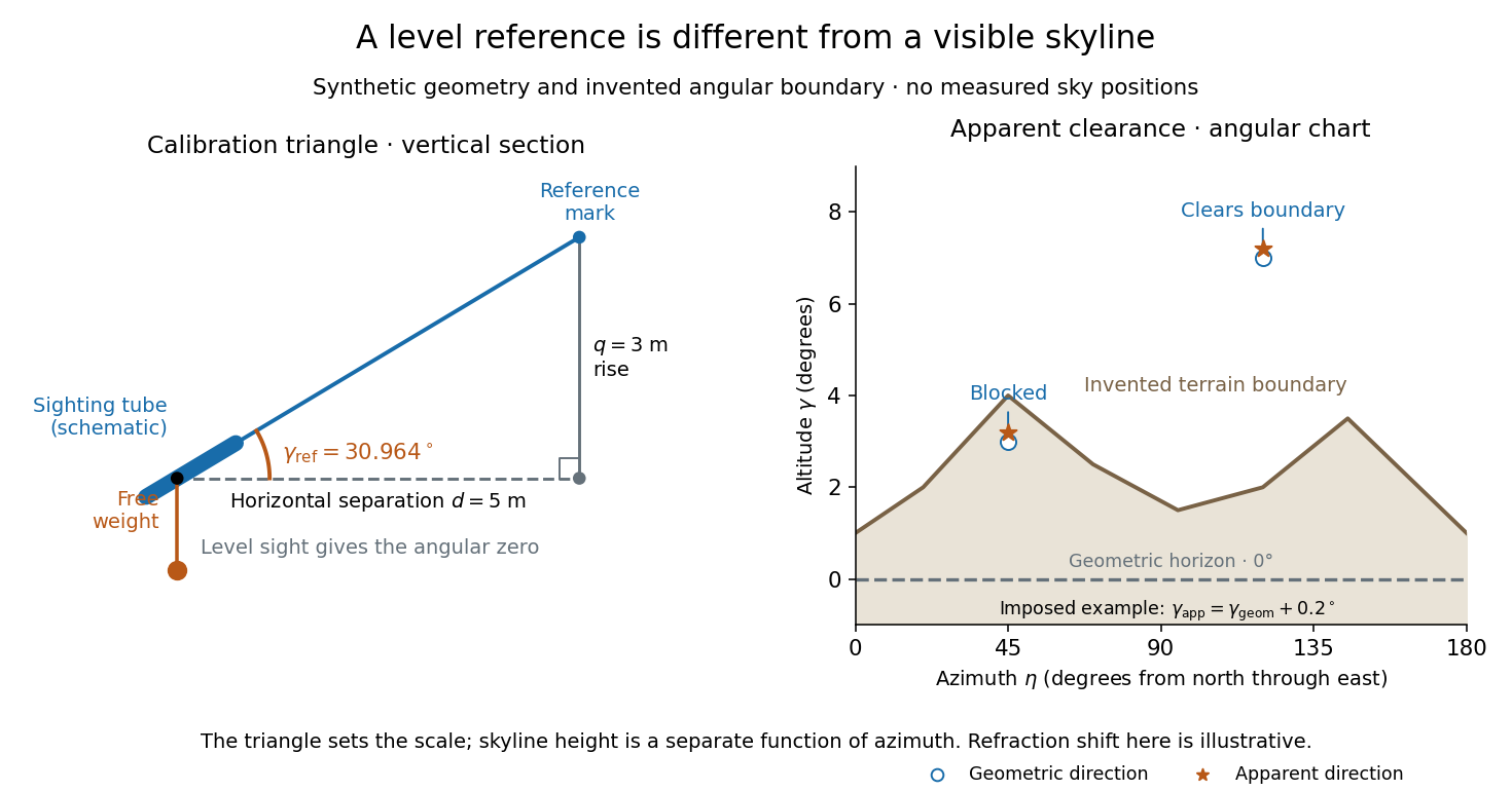
Synthetic calibration triangle and invented terrain boundary; angular zero, apparent altitude and geometric horizon are separate
. Details. 
Even an unobstructed sea boundary need not coincide with the astronomical horizon. On a spherical Earth of radius , an observer at height sees the unrefracted tangent to the surface at a downward angle satisfying . The right-angle tangent triangle supplies this relation; the visible boundary then has altitude . With illustrative and , , before atmospheric refraction. Raising the eye therefore changes the visible boundary without redefining the horizontal plane.
The US Naval Observatory's rise/set definitions explicitly distinguish the geometric reference from apparent contact with a visible disk: the standard Sun calculation puts its centre below the horizontal plane, combining an average radius with of atmospheric refraction. An angular minute is in the minute and second of arc convention. This is an operational average under stated conditions, rather than a universal zero of altitude. The same source identifies weather, local topography and observer height as limits on predicted rise/set time. An observation log should therefore retain the level reference, site and eye height, terrain profile, observation time, and whether each reported altitude is geometric or apparent. [ref]
https://aa.usno.navy.mil/faq/RST_defs. US Naval Observatory: Rise, set and twilight definitions, geometric horizon and observational limitations
. Zenith Created 2026-10-06 Updated 2026-10-14
The zenith is the point on the celestial sphere in the direction of the observer's local upward vertical. In the horizontal coordinate system, its unit vector is and its altitude is . The zenith belongs to the observer's site; it is not generally the north celestial pole, whose altitude depends on geographical latitude. A direction's zenith distance is its nonnegative angle from the zenith, so . A direction of altitude therefore has zenith distance . [ref]
https://www.astro.uvic.ca/~tatum/celmechs/celm6.pdf. Jeremy Tatum: Celestial mechanics, section 6.2, zenith and complementary zenith distance
.At the zenith, every value of azimuth produces . There is no horizontal component to identify a bearing: cannot provide a geometrically meaningful azimuth, even if software returns a number. This coordinate singularity is a defect of the angular description; the viewing direction itself remains regular. The same ambiguity occurs at the opposite downward vertical. Near the zenith, two directions at fixed altitude separated by a small azimuth increment have separation to first order, with angles in radians. At altitude , a azimuth increment spans only about on that small arc. An optical telescope can consequently require a large bearing change for a small change of pointing near the zenith; working with unit vectors avoids inventing a preferred bearing at the singular point.
Altitude Created 2026-10-06 Updated 2026-10-14
Altitude , also called elevation angle, is the signed angle from the astronomical horizon to a viewing direction, measured in the vertical plane containing that direction and the zenith. Its range is : positive altitude is above the horizontal plane, zero altitude lies on the astronomical horizon, and points to the zenith. Altitude measures direction, rather than a Euclidean distance or a height in metres. In the local horizontal coordinate system, ; the dot product makes the sign unambiguous even for directions below the astronomical horizon.
A concrete motivating observation is the Exploratorium Teacher Institute's Height Sight activity. Its inclinometer uses a sighting tube fixed to a card and an angular scale, with a string and small weight hanging from the scale's pivot. A partner reads where the freely hanging string meets the scale. Sighting a level target should give a readout near zero; sighting a taller target gives an angular height. The activity asks the observer to move closer and farther: the closer position gives the larger angle. The interpretation is that the readout measures the tube's tilt relative to the gravity reference, while converting that angle to a physical height also requires distance and eye height. The activity also extends the inclinometer to sky observations. [ref]
https://www.exploratorium.edu/snacks/height-sight. Exploratorium Teacher Institute: Height Sight, construction, level check and distance-dependent angular observations
.The following calibration and sky sequence is a proposed extension, with no claimed observing dataset. First establish two reference marks at the same height with a water level, rather than assuming that a sloping floor or distant ridge is horizontal. Keep the inclinometer in a vertical plane, sight between the marks, wait for the weight to settle, and read the zero several times. Next sight a mark whose independently measured rise above the tube and horizontal separation are known; a right triangle predicts . A synthetic , gives . Checking both zero and this nonzero angle can reveal a wrongly attached tube or a scale read from the wrong end. Use level separation, not distance along inclined ground.
If the scale's indicated altitude is , estimate its additive zero from the level sight, then obtain apparent altitude . For synthetic readings and , the corrected altitude is , close to the calibration prediction. Declaring illustrative readout bounds of for each reading gives a conservative combined bound of on ; these bounds are assumptions, not measured performance. Repeatability tests the variation between readings, whereas a persistent zero offset remains a systematic measurement error. Include uncertainty in the reference rise and separation before judging agreement.
At a fixed site, sight a recognizable star, record the observation time, corrected altitude and north-through-east azimuth, and repeat over a short interval. Record the terrain boundary at the same azimuth separately from the gravity-defined zero. The fixed-direction model in horizontal coordinate system predicts changing angular readouts as the Earth rotates; this is a prospective test, rather than a fabricated measurement curve. Keep the tube aligned, the string free of contact and shielded from wind, the eye at the same reference position, and repeat the level check afterward. Timestamp each sight so genuine sky motion is not mistaken for poor repeatability. An optical telescope with an angular readout can replace the sighting tube, but its mounting still needs an independently established level and angular zero.
The corrected instrument reads apparent altitude, including atmospheric refraction. Under ordinary conditions atmospheric refraction raises a low direction, so if is the upward angular correction, . Subtracting the instrument zero does not subtract . Record site height, temperature and pressure if applying a refraction model: these are explicit observer inputs in the US Naval Observatory's NOVAS software. A coarse inclinometer may be unable to resolve the correction, and a local weather reading alone does not determine every atmospheric layer. [ref]
https://aa.usno.navy.mil/downloads/Circular_180C_C.pdf. US Naval Observatory: NOVAS C3.0 user's guide, observer inputs and equ2hor refraction options
. Azimuth 2026-10-06
Azimuth is the angle about the local vertical measured in the astronomical horizon. A common convention increases eastward from north; some astronomical formulae use westward from north. The convention changes the sign in the hour angle transformation.
There are unlisted articles, also show them or only show them.