
In the interpretation of Christopher Kincaid and colleagues, slab rollback deforms and splits a mantle plume's thermal anomaly: one branch is swept toward the trench beneath the High Lava Plains, whereas the Snake River Plain records the overriding plate moving over a deformed plume conduit. Two opposite age progressions need not represent two stationary hotspots.
In the supplied map, ages decrease toward Yellowstone in the northeast and toward Newberry Volcano in the northwest. Southwestward North American Plate motion leaves older Snake River Plain volcanism to the southwest of the younger source expression. Meanwhile, rollback-driven, three-dimensional mantle flow, including toroidal mantle flow around the slab, carries a passive thermal anomaly trenchward beneath the High Lava Plains. The associated migrating heating and melting front produces the opposite younging toward Newberry Volcano.
The original experiment used a viscous syrup mantle analogue, a kinematically moved rigid slab, and an injected buoyant thermal plume. The result is advection of deformed plume heat by subduction-driven flow, rather than simple radial spreading of an intact plume head under a stationary plate. The mapped systematic progression principally concerns rhyolitic volcanism; basaltic eruptions are more diffuse in time. This laboratory result establishes a physically plausible explanation, not a unique observational proof of the deep source geometry.[ref]
Bifurcation of the Yellowstone plume driven by subduction-induced mantle flow by Christopher Kincaid and others. 2013, Figures 2–3, interpretation of the passive thermal anomaly and deformed conduit
For a Seattle resident, the main consequences are earthquake shaking and disruption, strongly modified by local ground conditions, plus location-dependent tsunami, landslide and volcanic hazards.
Three earthquake sources matter: the offshore Cascadia megathrust, deep events inside the Juan de Fuca Plate, and shallow upper-plate faults, including the Seattle Fault. Shaking can damage buildings, bridges, ports and utility networks, interrupting transport, electricity and water supply. Soft basin sediments can amplify or prolong shaking; saturated loose fill can undergo soil liquefaction and lateral spreading. Steep slopes can fail as landslides. The same regional event can therefore have very different consequences on bedrock and on artificial fill.[ref]
Large Cascadia tsunamis chiefly threaten the outer Pacific coast. Seattle's inland waterways also have local tsunami hazards from crustal faults and underwater landslides; one should not equate a Seattle waterfront site with an open-ocean coastal site. Cascade eruptions can affect the region through volcanic ash and transport disruption. Lahars are strongly channelled by river valleys, so their exposure is location dependent rather than uniform across Seattle. These geological differences influence infrastructure design, land-use decisions and emergency planning.[ref]
https://www.dnr.wa.gov/programs-and-services/geology/geologic-hazards/earthquakes-and-faults. Washington Geological Survey, earthquake and fault mechanisms
[ref]https://cmgds.marine.usgs.gov/data/geotech/pugetposter/geologic.html. USGS, Puget Sound deltas, historic liquefaction damage and the Seattle Fault
Cascadia subducts a young, warm plate and lacks the enormous plateau and crustal root of the central Andes; the central Andean Nazca Plate system also supports much deeper intraslab earthquakes. These are regional comparisons: neither western margin is uniform along its length.
First, the Juan de Fuca Plate entering Cascadia is young, typically of order 10 million years old, because its spreading ridge lies close to the margin. Its lithosphere is comparatively thin and warm. Much of the Nazca Plate entering the central Andes is older and colder. A cold plate carries low temperatures farther into the mantle, sustaining deep intraslab seismicity; the warm Cascadia slab loses its brittle seismogenic character much shallower. This concerns earthquakes within the slab, not the size of megathrust earthquakes: both margins can generate very large plate-interface events. The official warm-slab synthesis treats Cascadia as an endmember.[ref]
https://www.usgs.gov/publications/cascadia-subduction-zone-and-related-subduction-systems-seismic-structure-intraslab. USGS, 2002, warm-slab comparison and the 55 km deep Nisqually earthquake
Second, the central Andes have undergone major sustained crustal shortening and tectonic thickening, building a high plateau and locally roughly 60–70 km thick continental crust. Cascadia has an active volcanic arc and mountains but no equivalent continuous central-Andean plateau and crustal root. The difference reflects the accumulated history of convergence, upper-plate deformation, slab dip, trench motion and mechanical coupling, not just the instantaneous existence of subduction. The Andes include flat-slab segments with gaps in arc volcanism as well as normally dipping segments.[ref]
https://pubs.usgs.gov/of/2015/1031/e/pdf/of2015-1031-E.pdf. USGS, Seismotectonics of South America, tectonic summary and depth sections
[ref]https://escweb.wr.usgs.gov/share/mooney/54seismicvelocitystruct.pdf. USGS-hosted crustal seismic synthesis, central-Andean crustal thickness
A young warm incoming plate and a faster, colder incoming plate can therefore generate different thermal structures, dehydration patterns and deformation histories. Plate age alone is insufficient to predict the thickness of the overriding continental crust.
Hotter Archean mantle would generally produce thicker, more magnesium-rich oceanic crust, together with a more strongly depleted residual mantle. Greater melt production, not merely thermal expansion of an unchanged modern column, is the principal reason for the increased crustal thickness.
At a spreading ridge, upwelling peridotite undergoes adiabatic decompression melting. A higher mantle potential temperature makes the ascending mantle intersect the solidus at greater pressure and depth. It therefore melts over a longer decompression interval and generally reaches a larger integrated melt fraction. With comparable melt focusing, more melt is supplied per unit area of newly formed oceanic crust.
Modern normal oceanic crust is about 6–7 km thick and contains basaltic lavas, a sheeted dike complex, and gabbro with mafic cumulates at depth. An illustrative reconstruction for hot ambient Archean mantle gives about 25–35 km of oceanic crust, rather than a universal fixed thickness. Its primary liquids are more magnesium-rich than typical modern primary ridge liquids; their crystallization produces more olivine- and pyroxene-rich cumulates. The extracted liquid and its crystal products must be distinguished: the entire final oceanic crust need not be a homogeneous komatiite layer.[ref]
The residual peridotite loses more melt components, becoming more refractory and commonly harzburgite-rich. Thick buoyant basaltic crust, its later eclogitization, and the depleted underlying mantle can change the mechanics of subduction. A hotter mantle does not by itself establish how fast plates moved or whether a globally connected modern plate tectonics regime operated.
Komatiites, with very magnesium-rich primary liquids and high inferred eruption temperatures, provide evidence for hot melting, but may sample especially hot mantle plumes. Estimates of ambient mantle conditions also use less exceptional non-arc basalts. Variable source composition, water content, cooling, melt extraction and later alteration all limit the precision of a single inferred Archean thickness. The robust prediction is a larger melting column and melt yield, thicker igneous oceanic crust, and a more depleted residue.
Today the usual first melt is basaltic melt from the mantle wedge; in a hotter Archean subduction zone, melting of hydrated basaltic crust itself could generate sodic felsic melt of tonalite-trondhjemite-granodiorite composition. Distinguish a primary melt from the evolved melt ultimately added to the upper continental crust.
On the modern Phanerozoic Earth:
- Hydrothermal alteration introduces water into the incoming oceanic crust and locally into serpentinized mantle. Sediments also carry water in pore space and hydrous minerals.
- As the slab descends, heating and metamorphism break down hydrous minerals. Released fluids enter the hotter peridotite of the mantle wedge and lower its solidus, causing flux melting. Most ordinary modern slabs release fluids before extensive melting of their basaltic crust.
- The primary melt is predominantly hydrous basaltic magma. During ascent, storage and fractional crystallization, mafic minerals are removed and the remaining liquid evolves toward andesite, dacite and rhyolite compositions. Partial melting of recently emplaced mafic lower continental crust, magma mixing and some crustal contamination can contribute to felsic magma. Intrusive equivalents include diorite, tonalite and granodiorite.
This adds juvenile material derived from the mantle; simply remelting old continental crust is reworking, not net juvenile addition. The amount and depth of slab water release depend on its thermal history, as quantified in Subduction factory: 4. Depth-dependent flux of H2O from subducting slabs worldwide by Peter E. van Keken and others.
For the hotter Archean endmember posited in the question, a hotter mantle and a warm descending plate make it easier for hydrated basaltic crust to reach its solidus. Its partial melting can directly make silica-rich, sodium-rich tonalite-trondhjemite-granodiorite liquids, leaving a more mafic residue. Residual garnet and amphibole, and the presence or absence of residual plagioclase, help determine the rare-earth element and strontium signatures. These are not ultramafic liquids merely because the surrounding mantle was hotter.
The contrast is therefore commonly fluid-fluxed mantle melting followed by differentiation today, versus a greater potential contribution from direct melting of hydrated mafic crust in the hotter case. Tonalite-trondhjemite-granodiorite is not unique evidence for subduction: melting of thickened mafic crust can produce similar liquids. Nor are all modern arcs devoid of slab melting. These qualifications are central to The composite Archaean grey gneisses: Petrological significance, and evidence for a non-unique tectonic setting for Archaean crustal growth by Jean-François Moyen.
The expected broad contrast is a less mature, commonly thinner early juvenile continental crust, with more mafic material and abundant sodic tonalite-trondhjemite-granodiorite, rather than the more differentiated, potassium-rich granitoid component characteristic of much Phanerozoic continental crust. This is a secular tendency, not a single stratified column applicable throughout the Archean.
Archean terrains commonly expose tonalite-trondhjemite-granodiorite gneiss associated with greenstone belts containing basalt, komatiite and metasedimentary rocks. Many later granitoids are richer in potassium, including granite and granodiorite. The proportions changed during the Archean: a reconstruction from trace element ratios in sedimentary rocks infers a markedly mafic upper continental crust before about 3.0 Ga and a more felsic upper continental crust by 2.5 Ga. Thus “all Archean continental crust was mafic” would be wrong. A preserved tonalite-trondhjemite-granodiorite-dominated nucleus can be strongly felsic, including at depth; its composition is not identical to that of its original juvenile precursor.[ref]
Thickness needs a stated comparison. An influential seismic compilation found preserved Archean crust about 27–40 km thick, commonly without the thick high-velocity basal layer of its 40–55 km thick Proterozoic comparison provinces. That supports a relatively thin endmember, but is not a measurement of every original Archean continental crust, nor a demonstration that every Archean region was thinner than today's 35–40 km reference column. Tectonic thickening, magmatic underplating, erosion, delamination and preservation bias all alter what survives. The very thick lithospheric mantle beneath a craton must also not be mistaken for thick continental crust.[ref]
The transferable answer is therefore more mafic early juvenile precursors, widespread sodic tonalite-trondhjemite-granodiorite production, and variable thickness evolving through time; late Archean felsic nuclei can already resemble substantial modern continental crust.
A useful idealization is a thin sedimentary cover over a felsic upper continental crust, an intermediate middle continental crust, and a more mafic lower continental crust, ending at the Mohorovičić discontinuity at about 35–40 km. The boundaries within the continental crust are approximate compositional divisions, not three universal sharp interfaces.
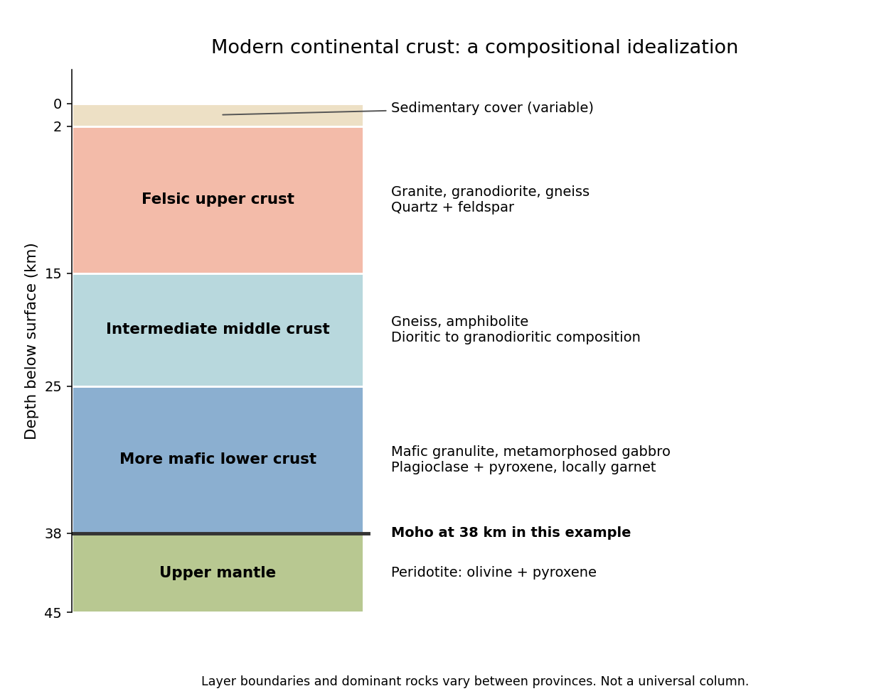
An idealized modern continental crustal column
. An original schematic for a 38 km thick continental crust. Depth ranges illustrate a compositional tendency; individual provinces have different lithologies and boundaries. Details.
- At the surface, a variable, commonly kilometre-scale sedimentary cover contains sediments and sedimentary rocks. Exposed crystalline basement can instead occur at the surface.
- In the upper roughly 15 km, representative rocks are granite, granodiorite and compositionally related gneiss, with quartz and feldspar. Sedimentary rocks, metamorphic rocks and volcanic rocks make this layer heterogeneous.
- At roughly 15–25 km, intermediate gneiss and amphibolite-facies assemblages become important. Diorite to granodiorite compositions and amphibole- and plagioclase-bearing rocks are representative.
- At roughly 25–38 km, mafic granulite and gabbro-derived metamorphic rocks are a useful average, with plagioclase, pyroxene and sometimes garnet. Some provinces instead have substantially intermediate or felsic lower continental crust.
- Below the Mohorovičić discontinuity is peridotite of the mantle, dominated by olivine and pyroxene. This is not a fourth crustal layer.
The important trend is increasing average mafic character with depth, rather than a change from granite directly to peridotite. Granulite describes a metamorphic facies, not a unique chemical composition. The synthesis in Nature and composition of the continental crust: A lower crustal perspective by Roberta L. Rudnick and David M. Fountain combines seismic and petrological evidence for these distinctions.
Past exam of the plate tectonics course of the University of Oxford 2023 Question 3 d Solution 2026-10-25
The asthenosphere exists because the mantle's ability to deform is strongly dependent on temperature, pressure, composition, water and deformation mechanism. Cooling from the surface creates a strong lithosphere. Beneath it, hotter mantle deforms by material creep at much lower stress on geological timescales. The asthenosphere is predominantly solid weak rock, not a global ocean of magma. On the much shorter timescale of a seismic wave, it still supports S waves.
The hot shallow mantle can be close to its solidus. Water weakening of rocks and, in some settings, a small connected melt fraction can further lower effective viscosity. At greater depths, changes in pressure, homologous temperature, mineral structure and water storage modify the deformation laws; increasing depth does not imply indefinitely decreasing viscosity. Explaining a weak upper-mantle interval does not require every location to contain the same amount of melt.
There are several physically distinct boundaries to test. The thermal lithosphere-asthenosphere boundary describes a thermal transition, the mechanical boundary a contrast in long-term strength or viscosity, and the seismic lithosphere-asthenosphere boundary a change in seismic velocity or other wave properties. They need not have identical depths. A smooth geothermal gradient can explain broad thermal weakening, but a very sharp decrease of seismic velocity may require changes in melt fraction, hydration, composition or seismic anisotropy. A sharp shallow reflector within a craton might instead be an internal lithospheric boundary.[ref]
A global view of the lithosphere-asthenosphere boundary by Catherine A. Rychert and Peter M. Shearer. Abstract and pp. 495–498: converted-wave sharpness and the possibility that the imaged cratonic discontinuity lies within thicker lithosphere.
Begin with a thermal null model. A half-space cooling model givesIf a thermal boundary corresponds to a fixed temperature , its depth isso it deepens as the square root of plate age. Test that prediction against independently determined seafloor ages, bathymetry and heat flux. An oceanic plate cooling model adds finite thickness and basal heat supply, allowing the old-age depth to approach a finite value. For continents, include radiogenic heating, crustal thickness, the history of continental rifting or tectonic thickening, and advective heating by magma or mantle flow. A cold, dry craton and a recently extended volcanic region should not share the same thermal profile.
Then calculate the observable consequences of competing mechanisms rather than merely assigning a boundary to a map:
- Use receiver functions from both P-to-S conversion and S-to-P conversion to constrain the depth and sharpness of a negative seismic velocity contrast. Check for crustal reverberations and whether the result changes with incident direction or frequency. Combine these with Rayleigh waves, Love waves and seismic tomography to constrain the broader shear-wave velocity profile.
- Measure seismic attenuation and seismic anisotropy. Elevated temperature, small amounts of melt and aligned minerals can all affect apparent seismic velocity, but predict different attenuation, polarization and directional patterns. Convert laboratory elastic and anelastic measurements into synthetic seismic observations at the relevant frequencies.
- Obtain magnetotelluric sounding constraints on electrical conductivity, together with surface heat flux. Connected melt or hydrated material can enhance electrical conductivity, but the interpretation depends on composition and connectivity. Joint thermal, seismic and electrical modelling is more discriminating than any single proxy.
- Use mantle xenoliths and erupted magmas to constrain pressure, temperature, water content, melt depletion and composition, recognizing that transport can alter a sample. Relate these observations to geodynamic modelling of mantle convection, slab flow, mantle plumes and lithospheric rejuvenation.
Compare models against the observed boundary depth and its sharpness, including uncertainty and resolution. An age–depth trend with matching heat flux favours thermal control; a sharp discontinuity that fails the thermal prediction but coincides with an electrical anomaly can support a melt- or hydration-related transition. Neither observation alone proves a unique cause. The spatially varying boundary is best understood as the result of thermal evolution interacting with composition, fluids and deformation history.
Past exam of the plate tectonics course of the University of Oxford 2023 Question 3 c Solution 2026-10-25
Elasticity lets the lithosphere share a load with neighbouring regions through lithospheric flexure. Beneath the centre of a localized load, subsidence is generally smaller than the local isostasy estimate, so the deposited surface stands higher. The surrounding plate also bends down, and a more distant flexural forebulge may rise. The extra support is regional bending resistance, rather than removal of the load's mass.
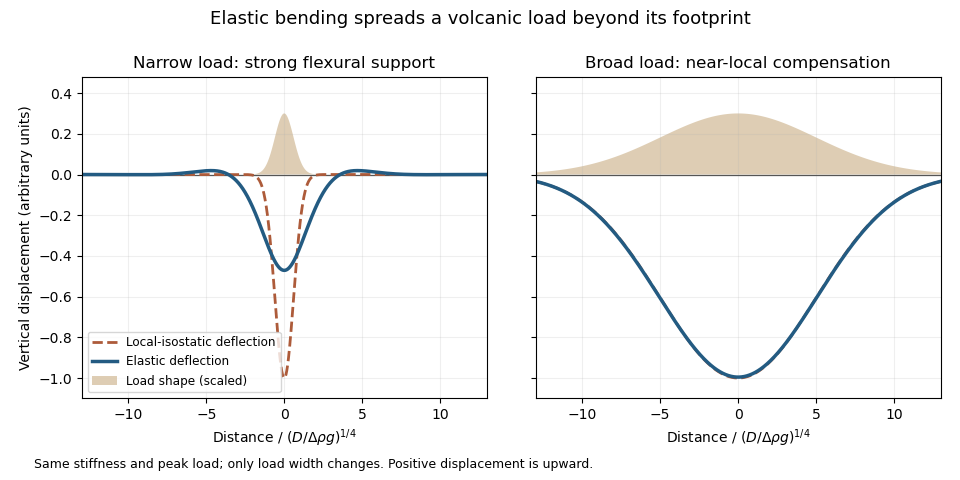
An original elastic-plate calculation contrasting narrow and broad loads at the same flexural rigidity; a broad load approaches local isostasy
. Details. 
The controlling comparison is load width against the lithosphere's flexural length, which increases with flexural rigidity and decreases with the relevant buoyant geophysical density contrast. Equivalently, the flexural support ratio becomes large for short-wavelength loading. A very broad nearly uniform load produces little curvature in its interior, so even a strong elastic lithosphere has a nearly local isostatic adjustment there. Bending matters most near its edges. A narrow load requires more curvature and can be supported appreciably by the surrounding elastic lithosphere.
The Deccan Traps form a broad continental large igneous province. The volcanic edifices of the Hawaiian Islands are more localized loads on an old oceanic lithosphere, for which regional bending and a flexural moat are prominent. Under the usual broad-Deccan versus narrow-Hawaiian-load comparison, elastic strength matters more for the Hawaiian Islands. The more coherent mantle-dominated strength of an old oceanic plate can reinforce this contrast. It cannot be deduced simply from “oceanic” versus “continental”: a cold Indian craton can be strong, and a site's effective elastic thickness depends on its thermal and loading history.
For an initially submerged Hawaiian load, replacing seawater changes both the load and buoyant restoring contrast. At fixed deposited thickness, the added load relative to the initial water column uses the rock-minus-water density, and the restoring term uses the mantle-minus-water density. An emerged island requires separate treatment of its subaerial and submerged portions. These corrections change the local isostasy reference but do not remove the importance of load width for lithospheric flexure. The broad Hawaiian swell should also be distinguished from the narrower volcanic load: deeper thermal or dynamic support of the Hawaiian swell is not the same mechanism as elastic support of the volcanic ridge.
Finally, over long periods material creep, yielding and thermal modification can reduce elastic support. Without measured load geometries, ages and effective elastic thicknesses, the ranking is a justified qualitative expectation rather than a theorem valid for every continental and oceanic load.
Past exam of the plate tectonics course of the University of Oxford 2023 Question 3 b Solution 2026-10-25
The volume alone does not determine a unique change of elevation. A local isostatic response to an added surface layer depends on its thickness and density, so the Deccan Traps' footprint must be specified or retained as a parameter.
Let the deposited basalt have uniform thickness and density , where and is the loaded area. Let be downward displacement of the original land surface, and let be the density of displaced mantle. Assume a subaerial, laterally extensive deposit, negligible air density, unchanged thickness and density of the pre-existing crust, and complete local isostatic adjustment. Take the magma supply to be external to the local compensation column, and neglect cooling, erosion, magmatic underplating and any deep thermal or source-depletion anomaly.
Choose a compensation depth beneath all the displaced interfaces. The added column mass per unit area is . Downward translation of the pre-existing crust replaces a thickness of mantle within the column, reducing its mass by . Equality of hydrostatic pressure at the compensation depth therefore givesThe newly formed top of the basalt stands above the depressed original surface. Consequently the change of the region's top-surface elevation isThus the original substrate subsides, but the top of the deposit rises if . Distinguishing these two surfaces prevents reporting the large downward displacement as the change in plateau elevation.
For an explicitly illustrative choice , and , the deposit is 1000 m thick, the substrate subsides about 879 m, and the final surface rises about 121 m. This is a conditional estimate, not a number fixed by the paper. Half that footprint would double all three heights under the same assumptions. For a nonuniform deposit, local isostasy gives the same relation pointwise with ; the total volume still cannot specify a unique local elevation.
Past exam of the plate tectonics course of the University of Oxford 2023 Question 3 a Solution 2026-10-25
Use a rock strength envelope: at each depth plot the smaller differential stress needed for frictional failure and for sustained ductile material creep at a specified strain rate. Shallow rock generally strengthens with depth because effective confining pressure increases; sufficiently deep hot rock weakens because thermally activated material creep becomes efficient.
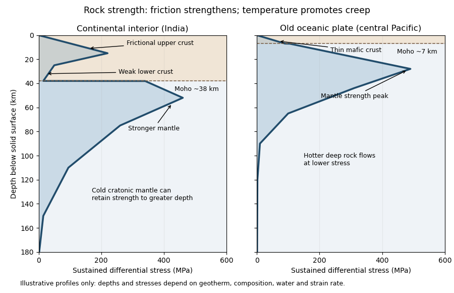
Illustrative rock-strength envelopes for a continental interior and an old central-Pacific plate; these are conceptual profiles, not measurements
. Details. 
At shallow depth, Byerlee's law or a Mohr-Coulomb failure criterion gives a relation of the formwhere is cohesion, a coefficient of friction, the compressive normal stress and the pore pressure. Increasing overburden generally increases effective stress, hence the frictional strength. Conversion from fault shear stress to differential stress depends on the stress regime and fault orientation; a sketch should not label a universal numerical slope. High pore pressure or weak fault gouge can lower the frictional strength substantially.
A simplified dislocation creep relation isHere is activation energy, activation volume, the molar gas constant and absolute temperature; and depend on composition and deformation mechanism. At fixed strain rate, increasing temperature usually decreases the required stress strongly. The competing effects of pressure, water weakening of rocks, grain size and composition also matter. The intersection with frictional failure gives a brittle-ductile transition, not a change from solid to liquid.
For the Indian continental interior, a useful first sketch has an upper-crustal strength peak, a weaker lower continental crust, and renewed strength in lithospheric mantle beneath the Moho. Quartz-bearing rocks can undergo ductile material creep at conditions where colder, drier olivine-rich mantle retains appreciable strength. This creates a possible two-peak, or “jelly sandwich”, rock strength envelope. With further depth the mantle also weakens. A cold craton can retain strong lithospheric mantle to much greater depths than a tectonically heated continental region.
For the central Pacific, show thin mafic oceanic crust above a relatively thick layer of strong lithospheric mantle. There need not be a conspicuous weak lower-crustal layer. Much of the integrated strength can reside below the Moho, with a broad strength peak followed by ductile weakening towards the asthenosphere. Cooling and age control the thickness: young hot oceanic lithosphere would give a much shallower and weaker profile than an old central-Pacific plate.
The plotted Moho depths of about 38 km and 7 km, and all plotted stresses, are illustrative assumptions. “India” alone does not specify a unique geothermal gradient, water content or strain rate, and the Pacific includes plates of different ages. The robust comparison is the possible crust–mantle layering in a continent versus the thin oceanic crust and mantle-dominated strength of an old oceanic plate. The Moho is a compositional boundary; neither it nor the deepest small plotted strength is automatically the seismic lithosphere-asthenosphere boundary.
Past exam of the plate tectonics course of the University of Oxford 2023 Question 2 c Solution 2026-10-25
Prioritize accessible ancient lacustrine deposits at a preserved river delta, especially fine-grained, clay mineral-bearing mudstones, with nearby evidence of groundwater or hydrothermal circulation. The target should combine past habitability, good biosignature preservation and practical access to minimally altered rock.
An inlet valley, a river delta and a stratified basin together can establish a connected fluvial–lake paleoenvironment on Mars. A long-lived lake offers liquid water, chemical transport and a sustained habitat, while a river delta concentrates material from a larger catchment. Distal mudstone is particularly attractive: fine particles can adsorb organic molecules, burial reduces exposure, and quiet deposition can preserve small-scale structures. Rover observations have independently established ancient lake and river delta settings on Mars, so this is a geological search strategy grounded in observed environments.[ref]
A Habitable Fluvio-Lacustrine Environment at Yellowknife Bay, Gale Crater, Mars by John P. Grotzinger and others. Abstract: a fluvio-lacustrine sedimentary environment with inferred chemical conditions suitable for microbial life.
[ref]Perseverance rover reveals an ancient delta-lake system and flood deposits at Jezero crater, Mars by Nicolas Mangold and others. Abstract: delta-lake deposition followed by later high-energy flooding.
A second high-value setting is an ancient hydrothermal deposit, particularly silica-rich precipitates, spring terraces or mineralized groundwater fractures near a heat source. Such environments combine water-rock interaction, chemical disequilibrium and the possibility of rapid mineral entombment. Distal, moderate-temperature parts of a hydrothermal circulation system are preferable to strongly reheated zones where organic molecules would be destroyed. Orbital observations identify candidate ancient hydrothermal deposits on Mars, although their geological interpretation requires testing on the ground.[ref]
Ancient hydrothermal seafloor deposits in Eridania basin on Mars by Joseph R. Michalski and others. Abstract and inferred deep-water hydrothermal setting; evidence for an environment rather than evidence of life.
Carbonate-bearing sedimentary deposits can also preserve textures and chemical records of former water, but precipitation of carbonate alone is not a biosignature.Choose ancient deposits with good stratigraphy, limited later metamorphism and relatively recent exposure by erosion, or sample beneath the irradiated surface. Present exposed organic molecules can be destroyed by cosmic rays, radiolysis and oxidizing surface chemistry, so a drill, fresh scarp or recently excavated material improves the preservation prospects. Laboratory irradiation experiments on Martian analogue materials demonstrate why shallow ancient surface exposure can erase an organic record.[ref]
NASA Experiment Suggests Need to Dig Deep for Evidence of Life on Mars by National Aeronautics and Space Administration. 27 June 2022, experiments on radiation-driven destruction of amino acids and implications for subsurface sampling.
At the site, relate every sample to its sedimentary facies and mineral context. Seek several independent, spatially associated biosignatures: plausible microscopic structures, distinctive organic molecules, and isotope fractionation consistent with a biological process. Each has nonbiological alternatives, so test water-rock interaction, mineral self-organization and contamination before inferring life. Include control samples from adjacent unpromising rocks and track terrestrial contamination. A safe landing ellipse with traversable exposures of several related sedimentary facies is more useful than a spectacular but inaccessible single outcrop. The desired outcome is contextual evidence that can distinguish former life from merely former habitability.
Past exam of the plate tectonics course of the University of Oxford 2023 Question 2 b Solution 2026-10-25
Interpret habitability as the ability to sustain life with broadly terrestrial biochemistry. Accessible liquid water, usable free energy, suitable chemical ingredients and sufficiently persistent conditions are the central requirements. Earth-like geography, a breathable atmosphere and actual habitation are not part of that definition.
A viable local physical environment. The relevant temperature and pressure must permit liquid water where the organisms live. For a surface habitat this normally requires an appropriate atmosphere and surface temperature; the roughly 6.1 millibar triple-point pressure of pure water is a minimum phase constraint, not a guarantee of a temperate surface. High salinity, extreme acidity and low water activity can make apparently wet environments unsuitable for known life. A subsurface ocean beneath ice can provide liquid conditions even when the surface is frozen, so the entire body need not lie in the conventional surface-water habitable zone.
A suitable orbit and rotation. For a surface-water planet, orbital distance must give an absorbed radiation budget compatible with liquid conditions after the body's Bond albedo, atmosphere and greenhouse effect are included. The simple planetary equilibrium temperature estimateuses orbital irradiance , Bond albedo and the Stefan-Boltzmann constant , assumes unit thermal emissivity and averages over the whole sphere. It is not a prediction of surface temperature beneath a atmosphere with a greenhouse effect. Excessive absorbed energy risks a runaway greenhouse; inadequate surface heating can freeze surface water, although heat from the interior or tidal heating can maintain a subsurface habitat.
The orbit must persist without collision or ejection for a biologically useful interval. Large orbital eccentricity can produce extreme variations in heating, but neither exactly circular motion nor Earth's particular obliquity is essential. Rotation period and obliquity govern illumination and seasons; atmospheric and ocean heat flux determine how severe those variations become. Tidal locking does not automatically make a body uninhabitable, because sufficient heat transport can moderate the day–night contrast. A natural satellite also needs a stable orbit around its primary and a tolerable combination of irradiation and tidal heating: enough heating may maintain an ocean, whereas excessive heating can make the environment hostile. These are constraints on the body's location and path, without requiring a particular kind of surrounding planetary system.
An adequate chemical inventory and access to it. Known life uses carbon, hydrogen, nitrogen, oxygen, phosphorus and sulfur, together with catalytic trace elements. A rocky planet supplies mineral surfaces and reservoirs, but total inventory is not enough: chemical weathering, water-rock interaction or other transport must make nutrients accessible. A water-rich body with an ocean isolated from its rocky interior by a thick high-pressure ice layer could have difficulty recycling some nutrients; this is a possible limitation, not proof of sterility.
A usable energy supply. Photosynthesis can exploit light in an illuminated habitat. A dark subsurface habitat instead needs sustained chemical disequilibrium, for example oxidized and reduced species brought together by water-rock interaction, hydrothermal circulation or radiolysis. Warm water at complete chemical equilibrium is not, by itself, an energy supply for sustained metabolism.
Retention, protection and longevity. The body's mass, radius, surface gravity and thermal history affect retention of water and an atmosphere. Escape velocity must be considered together with gas temperature, molecular mass, atmospheric escape and replenishment: there is no universal Earth-mass threshold. An atmosphere, ice or rock overburden can protect life from damaging ionizing radiation and short-wavelength light. An intrinsic planetary magnetic field can modify charged-particle exposure and escape, but it is neither a universal requirement nor a guarantee of retention.
Finally, conditions must last long enough. Stored formation heat, radiogenic heating and possibly tidal heating can maintain circulation and chemical exchange. Plate tectonics can recycle materials and support a carbonate-silicate cycle, but it is not established as a necessary condition for every habitable body: conditional long-term carbon cycling is possible on a stagnant-lid planet as well.[ref]
Carbon Cycling and Habitability of Earth-Sized Stagnant Lid Planets by Bradford J. Foley and Andrew J. Smye. Abstract and coupled thermal/carbon-cycle model; habitability is conditional on degassing, weathering and interior evolution.
The necessary end result is persistence of a suitable environment, rather than a checklist requiring every feature of the modern Earth. Past exam of the plate tectonics course of the University of Oxford 2023 Question 2 a Solution 2026-10-25
Plate tectonics changes the environments in which natural selection, gene flow and extinction operate. It influences both the persistence of habitable conditions and the geographical and chemical opportunities for evolution. It does not prescribe a unique sequence of biological innovations.
Separation of continents by continental rifting divides populations and reduces gene flow, promoting allopatric speciation. Continental collision or newly exposed land connections can reunite populations, permit dispersal and introduce competitors or predators. These mechanisms connect biogeography to continental configuration. Changing the amount and fragmentation of shallow continental shelf habitat can also change the opportunities for diversification of marine organisms.
Over long intervals, volcanic outgassing, silicate weathering, carbonate burial and subduction exchange carbon among the interior, atmosphere and ocean. In a suitable regime, warmer, wetter conditions increase silicate weathering, remove atmospheric carbon dioxide and weaken the greenhouse effect. This negative feedback can support long-lived habitability, though it depends on exposed fresh rock, available water and reaction rates.[ref]
A negative feedback mechanism for the long-term stabilization of Earth's surface temperature by James C. G. Walker and others. Weathering–carbon dioxide–temperature coupling in the proposed long-term stabilization mechanism.
Mountain building changes precipitation, erosion and delivery of nutrients to the ocean, affecting primary production and organic carbon burial.The opening and closure of ocean gateways changes ocean circulation, transport of heat and the supply of oxygen to deep water. Together with movement of land through different latitudes and changes in sea level, this reorganizes climate and habitat. Enhanced organic carbon burial can change atmospheric oxygen over long intervals, while a poorly ventilated ocean can develop ocean anoxia. Such chemical changes alter which forms of metabolism are viable.
Hydrothermal circulation at spreading ridges and through fractured rock supplies chemical disequilibrium and mineral surfaces. For example, serpentinization can produce hydrogen usable by chemolithotrophy when suitable electron acceptors are available. This supplies a possible setting for abiogenesis and early ecosystems; it does not establish that life originated there.
There can also be abrupt disruption. Rapid emplacement of a large igneous province can change climate through gas release; sulfur-bearing aerosols can initially cool, whereas sustained carbon dioxide release can warm and contribute to ocean acidification and ocean anoxia. Such perturbations can contribute to mass extinction, followed by adaptive radiation among survivors. The Deccan Traps exemplify the scale of volcanism involved, but their association with the Cretaceous–Palaeogene boundary does not justify attributing the entire biological crisis to volcanism alone. Both gradual environmental reorganization and rare rapid perturbations belong in the explanation.
Past exam of the plate tectonics course of the University of Oxford 2023 Question 1 c Solution 2026-10-25
Repeated assembly and dispersal are supported by mutually consistent paleogeography, paleomagnetism, dated collision belts and subsequent rifted margins. A useful reconstruction must explain both former connections and later separation, at the same geological ages.
For the youngest well-constrained example, Pangaea, matching continental outlines become more compelling when the fit uses the continental edges rather than mobile modern shorelines. More discriminating evidence includes the continuation of mountain belts, sedimentary successions and distinctive basement rocks across now-separated continents. Correlated terrestrial fossil assemblages and the distribution of glacial deposits become geographically coherent when the continents are restored. Each observation alone can have alternatives, but a single reconstruction that satisfies several independent tests is much harder to explain by coincidence.
For older examples, the most useful surviving record lies within the cratons and their margins. Dated suture zones, ophiolites, metamorphic belts and pressure-temperature-time paths document former ocean closure and continental collision. Restoring now-separated belts to continuity tests an assembly. Subsequent continental rifting, matching dike swarms, large igneous provinces and the transition to passive margins test its breakup. Uranium-lead dating of zircon, including detrital zircon populations and sedimentary provenance, helps establish whether the proposed connections existed at the same time.
Paleomagnetism supplies an independent quantitative test. A primary remanent magnetization constrains ancient latitude and orientation. After a proposed relative rotation brings two blocks together, compatible apparent polar wander paths over an interval support their travelling together; divergence of those paths can document separation. Radiometric dating, a paleomagnetic fold test and a paleomagnetic reversal test help identify primary records and distinguish them from remagnetization. There remain important ambiguities: conventional paleomagnetism does not fix absolute longitude, and sparse ages, later deformation and true polar wander complicate a reconstruction.
The broad succession is Columbia or Nuna, assembled mainly around 1.9–1.6 billion years ago; Rodinia, assembled mainly around 1.1–0.9 billion years ago and dispersed in stages during the later Proterozoic; and Pangaea, assembled by roughly 300 million years ago and breaking apart from roughly 200 million years ago. These are broad intervals rather than synchronous global events. A quantitative Nuna reconstruction combines paleomagnetism with the histories of continental margins rather than relying only on matching rock ages.[ref]
Assembly and breakup of the core of Paleoproterozoic-Mesoproterozoic supercontinent Nuna by David A. D. Evans and Ross N. Mitchell. pp. 443–446, reconstruction of the Nuna core and tests using paleomagnetic and tectonostratigraphic records.
Repeated global peaks in dated magmatism and metamorphism offer supporting evidence, but cannot prove a supercontinent cycle by themselves: erosion, burial and preferential preservation also change the observed age distribution. The persuasive case is the recurrence of dated assembly–breakup sequences in different continental configurations, with stronger geometric constraints for Pangaea than for the older supercontinents. A Wilson cycle describes an individual ocean's opening and closure; a supercontinent cycle concerns the much larger-scale continental assembly and dispersal.
Past exam of the plate tectonics course of the University of Oxford 2023 Question 1 b Solution 2026-10-25
Slab pull is generally the largest direct driving contribution for plates attached to substantial cold descending slabs. Cooling makes oceanic lithosphere negatively buoyant; sinking slabs transmit a pulling force to the rest of the tectonic plate. The comparison is a force balance, so the following driving and resisting processes both matter.
- Ridge push is gravitational sliding away from an elevated spreading ridge. Cooling, contraction and deepening of oceanic lithosphere establish the lateral difference in integrated pressure; ridge push is not simply magma squirting sideways into a plate.
- Basal traction on a tectonic plate transfers shear stress between the lithosphere and circulating mantle. It can help or oppose plate motion, depending on their relative velocities. Slab suction is the contribution of slab-induced mantle flow and its associated pressure and traction to nearby plate motion.
- Frictional sliding along faults, shearing along the plate interface, bending of the incoming slab and viscous dissipation in the surrounding mantle resist plate motion. Continental collision introduces additional resistance through buoyancy and deformation of thick continental crust.
- Mantle plumes and continental rifting can locally promote uplift, weakening and separation, but do not provide a universal explanation for all plate motion.
The first two gravitational contributions ultimately belong to the same coupled mantle convection system: the plates are its cold upper thermal boundary layer. They are not passive rafts on a prescribed conveyor belt. A plate with little attached descending slab need not have slab pull as its largest local driver, and a large gross slab pull can be partly consumed by bending and interface resistance. Geological observations and force comparisons nonetheless support the general dominance of slab pull for rapidly moving subducting plates.[ref]
What causes earthquakes? by British Geological Survey. Section explaining mantle circulation, ridge push and slab pull, including the association between subducting plate edges and faster motion.
Past exam of the plate tectonics course of the University of Oxford 2023 Question 1 a Solution 2026-10-25
Choose an ocean–continent convergent margin. The essential relationship is recycling of oceanic lithosphere by subduction, together with production and modification of crust in a volcanic arc.
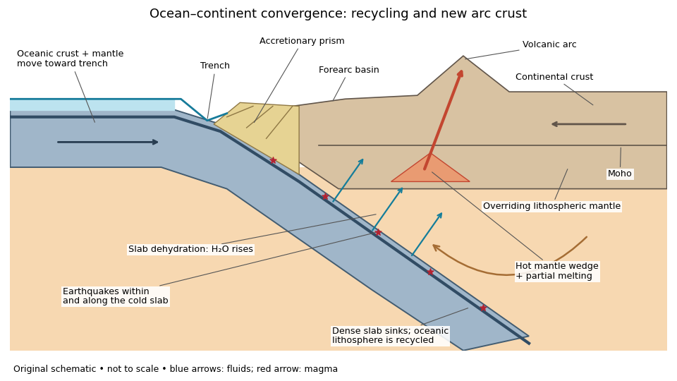
An original ocean–continent subduction cross-section, with slab recycling, fluid release and arc crust production
. Details. 
The incoming tectonic plate consists of thin oceanic crust, chiefly basalt and gabbro, above colder lithospheric mantle. As that oceanic lithosphere approaches the subduction zone, bending produces the subduction trench. Its cold interior can become denser than the surrounding mantle; the resulting slab pull helps sustain subduction. The descending slab carries both oceanic crust and lithospheric mantle into the interior. Thus the recycled unit is an entire portion of lithosphere, rather than just its crust.
At the subduction trench, some incoming sediment is scraped off and stacked by thrust faults into an accretionary prism. Material can also be added beneath the overriding plate by tectonic underplating. A forearc basin collects sediment between the accretionary prism and the volcanic arc. This is an accreting example: other convergent margins lose upper-plate material through tectonic erosion, so an accretionary prism is not universal.
The cold slab undergoes increasing pressure and metamorphism. Conversion of basaltic rocks and gabbro towards eclogite increases their density, while slab dehydration releases water from hydrated minerals. The rising fluid lowers the solidus of hot peridotite in the mantle wedge, causing flux melting. The usual source of arc magma is therefore the fluid-modified mantle wedge; extensive slab melting is not required. Thermal-petrological calculations show that the depth and amount of slab dehydration depend on the incoming slab's thermal structure.[ref]
Buoyant magma rises through the overriding plate, freezes in igneous intrusions or erupts in the volcanic arc. Fractional crystallization, interaction with existing continental crust and repeated intrusion can produce more evolved arc magmas and add new crust. Some material merely reworks old crust, and simultaneous tectonic erosion can remove it: volcanism alone does not measure net continental growth. Tectonic shortening, folding and thrust faults can thicken and raise the upper plate.
The Wadati-Benioff zone marks earthquakes along and within the cold descending slab. Shallow interface earthquakes reflect unstable slip where the plates are coupled; deeper earthquakes require mechanisms such as dehydration embrittlement and are not simply dry shallow friction operating at every depth. In contrast, the hot mantle wedge deforms mainly by material creep. Together, the subduction trench, accretionary prism, forearc basin, volcanic arc and inclined seismicity connect surface features to the processes recycling and creating crust.
Using the preceding conductive estimate, warmer incoming crust is less dense. Interpret the given as the volumetric coefficient entering . The representative contrast givesFor , that is only about . Let be the vertical thickness of the anomalous slab material in a compensated column. Its mass deficit per unit area is approximately . If uplift adds compensating column mass , isostatic balance gives the thermal buoyancy support of topography:The reference density depends on which interfaces move in the assumed column model. For approximately equal densities and a near-horizontal km crustal layer, this gives m; using and gives about m. A modest dip changes the vertical intersection to approximately and does not change this order of magnitude. Different graphical flux choices and uncertain geometry change the number; they do not justify replacing a km crustal anomaly by a whole km lithospheric anomaly without additional information.
Thus the crust-only thermal contrast can supply tens of metres of isostatic relief, not kilometres. Its sign would favor greater thermal support from the warmer Juan de Fuca crust, so it cannot by itself explain why much of the central Andes stands higher than Cascadia. Crustal shortening and roots, whole-slab thermal structure, phase transformations, hydration, magmatic addition and dynamic stresses can dominate. If the stated expansion coefficient instead meant a linear solid expansion coefficient, the first-order density coefficient would be about three times larger; the estimate would still be well below kilometre-scale mountain relief.
To test isostasy, jointly measure surface topography, free-air gravity anomalies, Bouguer gravity anomalies and crustal thickness from receiver functions and seismic refraction surveys. An Airy isostasy interpretation predicts crustal roots beneath high terrain and a corresponding regional negative Bouguer signal; thermal or compositional compensation predicts different density structure. Compare gravity and geoid observations with compensated-column predictions over a range of wavelengths, and use gravity-topography admittance to test local versus flexural isostasy. A small long-wavelength free-air anomaly can support compensation, but is not a sufficient test by itself. GNSS uplift, leveling and dated marine or river terraces constrain transient or sustained vertical motion; seismic tomography and rock-density estimates constrain deeper buoyancy. Residual relief or gravity after these corrections may require dynamic topography or tectonic support. An actively deforming subduction margin need not satisfy instantaneous local isostatic equilibrium, even if the estimate above is a useful scale comparison.
The supplied plot gives surface heat flux, not a whole-crust mean temperature. At young ages its scatter is substantial. Representative readings suitable for an order-of-magnitude conductive calculation are near Ma and near Ma; plausible graphical ranges are roughly – and –, respectively. These are approximate choices within the plotted population, not uniquely determined statistical means or a digitization of its red curve.
Assume the same normal oceanic crustal thickness km, seafloor temperature , negligible internal crustal heating and a linear conductive profile. These are additional assumptions; the paper supplies conductivity but not thickness. With depth positive downward and the magnitude of the upward flux, Fourier's law givesThis is the crustal mean temperature from conductive heat flow, not the basal temperature, which is twice the excess above . Substitution of givesA sensible rounded answer is therefore about for the young crust and for the old crust, with a representative contrast K. The corresponding basal values are about and . The quoted graphical ranges instead yield mean temperatures about – and –, at the same assumed thickness.
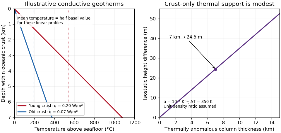
Original conductive temperature estimates and their crust-only thermal-buoyancy scaling; thickness, linear profiles and representative fluxes are explicit assumptions
. Details. 
The temperatures scale linearly with . Hydrothermal circulation can redistribute heat, especially in young permeable crust, and measurements through sediment need not equal the purely conductive cooling-model flux everywhere. The supplied study explicitly addresses the resulting oceanic heat-flow deficit.[ref]
Oceanic heat flow: implications for global heat loss by Derrick Hasterok and others. Abstract, hydrothermal circulation and low conductive measurements in young seafloor; examination Figure 2 supplies the filtered observations
Thus the calculation gives plausible incoming-crust averages under a stated model, not the entire plate's temperature or its later temperature at depth in the subduction zone.Yes: substantial along-strike segmentation is expected and observed in the Andes, but its geometry and dominant controls need not match Cascadia. The older Nazca Plate has a thicker cooled lithosphere and a larger thermal density excess relative to hot mantle than the young Juan de Fuca system. In a half-space cooling model, thermal thickness scales as , so the age comparison alone gives a thickness ratio . This changes the balance of slab buoyancy, bending resistance and mantle flow; it does not make the margin laterally uniform.
Changes in incoming ridge and plateau buoyancy, hydration, fracture zones, convergence obliquity, upper-plate thickness and motion can all alter slab dip and coupling. The Peruvian and Pampean flat-slab regions illustrate this: long nearly horizontal slab sections contrast with steeper subduction beneath active arc sections. Suppression or displacement of a hot mantle wedge explains why flat-slab subduction can coincide with volcanic gaps and deformation farther inland. The steeply dipping slab beneath much of the central Andes should not be conflated with every Andean segment.
The Juan Fernández Ridge is associated with the Chilean/Pampean transition, while the Nazca Ridge intersects the Peruvian system. However, association is not proof that crustal thickness alone supplies all the buoyancy. Wide-angle seismic observations at the Juan Fernández system found only moderate crustal thickening and motivated consideration of hydration as well as ridge emplacement.[ref]
Seismic investigations of the O'Higgins Seamount Group and Juan Fernández Ridge by Heidrun Kopp and others. Abstract and introduction, seismic profiles, flat-slab association and limits of a crustal-buoyancy explanation
The same combination of slab imaging, geodesy, volcanic chronology and incoming-plate characterization is needed to test causes. Thus the transferable idea is lateral variation in forces and material properties, not an identical three-segment pattern or one age-controlled mechanism. There are unlisted articles, also show them or only show them.