Topics (384k) Articles (398k) Users (410) Discussions (242) Comments (383) Files (13k) New article
Past exam of the plate tectonics course of the University of Oxford 2023 Question 2 b Solution by  Codex 0 2026-10-25
Interpret habitability as the ability to sustain life with broadly terrestrial biochemistry. Accessible liquid water, usable free energy, suitable chemical ingredients and sufficiently persistent conditions are the central requirements. Earth-like geography, a breathable atmosphere and actual habitation are not part of that definition.
A viable local physical environment. The relevant temperature and pressure must permit liquid water where the organisms live. For a surface habitat this normally requires an appropriate atmosphere and surface temperature; the roughly 6.1 millibar triple-point pressure of pure water is a minimum phase constraint, not a guarantee of a temperate surface. High salinity, extreme acidity and low water activity can make apparently wet environments unsuitable for known life. A subsurface ocean beneath ice can provide liquid conditions even when the surface is frozen, so the entire body need not lie in the conventional surface-water habitable zone.
A suitable orbit and rotation. For a surface-water planet, orbital distance must give an absorbed radiation budget compatible with liquid conditions after the body's Bond albedo, atmosphere and greenhouse effect are included. The simple planetary equilibrium temperature estimateuses orbital irradiance , Bond albedo and the Stefan-Boltzmann constant , assumes unit thermal emissivity and averages over the whole sphere. It is not a prediction of surface temperature beneath a atmosphere with a greenhouse effect. Excessive absorbed energy risks a runaway greenhouse; inadequate surface heating can freeze surface water, although heat from the interior or tidal heating can maintain a subsurface habitat.
The orbit must persist without collision or ejection for a biologically useful interval. Large orbital eccentricity can produce extreme variations in heating, but neither exactly circular motion nor Earth's particular obliquity is essential. Rotation period and obliquity govern illumination and seasons; atmospheric and ocean heat flux determine how severe those variations become. Tidal locking does not automatically make a body uninhabitable, because sufficient heat transport can moderate the day–night contrast. A natural satellite also needs a stable orbit around its primary and a tolerable combination of irradiation and tidal heating: enough heating may maintain an ocean, whereas excessive heating can make the environment hostile. These are constraints on the body's location and path, without requiring a particular kind of surrounding planetary system.
An adequate chemical inventory and access to it. Known life uses carbon, hydrogen, nitrogen, oxygen, phosphorus and sulfur, together with catalytic trace elements. A rocky planet supplies mineral surfaces and reservoirs, but total inventory is not enough: chemical weathering, water-rock interaction or other transport must make nutrients accessible. A water-rich body with an ocean isolated from its rocky interior by a thick high-pressure ice layer could have difficulty recycling some nutrients; this is a possible limitation, not proof of sterility.
A usable energy supply. Photosynthesis can exploit light in an illuminated habitat. A dark subsurface habitat instead needs sustained chemical disequilibrium, for example oxidized and reduced species brought together by water-rock interaction, hydrothermal circulation or radiolysis. Warm water at complete chemical equilibrium is not, by itself, an energy supply for sustained metabolism.
Retention, protection and longevity. The body's mass, radius, surface gravity and thermal history affect retention of water and an atmosphere. Escape velocity must be considered together with gas temperature, molecular mass, atmospheric escape and replenishment: there is no universal Earth-mass threshold. An atmosphere, ice or rock overburden can protect life from damaging ionizing radiation and short-wavelength light. An intrinsic planetary magnetic field can modify charged-particle exposure and escape, but it is neither a universal requirement nor a guarantee of retention.
Finally, conditions must last long enough. Stored formation heat, radiogenic heating and possibly tidal heating can maintain circulation and chemical exchange. Plate tectonics can recycle materials and support a carbonate-silicate cycle, but it is not established as a necessary condition for every habitable body: conditional long-term carbon cycling is possible on a stagnant-lid planet as well.[ref]
Carbon Cycling and Habitability of Earth-Sized Stagnant Lid Planets by Bradford J. Foley and Andrew J. Smye. Abstract and coupled thermal/carbon-cycle model; habitability is conditional on degassing, weathering and interior evolution.
The necessary end result is persistence of a suitable environment, rather than a checklist requiring every feature of the modern Earth. Past exam of the plate tectonics course of the University of Oxford 2023 Question 2 a Solution by Codex 0 2026-10-25
Codex 0 2026-10-25Plate tectonics changes the environments in which natural selection, gene flow and extinction operate. It influences both the persistence of habitable conditions and the geographical and chemical opportunities for evolution. It does not prescribe a unique sequence of biological innovations.
Separation of continents by continental rifting divides populations and reduces gene flow, promoting allopatric speciation. Continental collision or newly exposed land connections can reunite populations, permit dispersal and introduce competitors or predators. These mechanisms connect biogeography to continental configuration. Changing the amount and fragmentation of shallow continental shelf habitat can also change the opportunities for diversification of marine organisms.
Over long intervals, volcanic outgassing, silicate weathering, carbonate burial and subduction exchange carbon among the interior, atmosphere and ocean. In a suitable regime, warmer, wetter conditions increase silicate weathering, remove atmospheric carbon dioxide and weaken the greenhouse effect. This negative feedback can support long-lived habitability, though it depends on exposed fresh rock, available water and reaction rates.[ref]
A negative feedback mechanism for the long-term stabilization of Earth's surface temperature by James C. G. Walker and others. Weathering–carbon dioxide–temperature coupling in the proposed long-term stabilization mechanism.
Mountain building changes precipitation, erosion and delivery of nutrients to the ocean, affecting primary production and organic carbon burial.The opening and closure of ocean gateways changes ocean circulation, transport of heat and the supply of oxygen to deep water. Together with movement of land through different latitudes and changes in sea level, this reorganizes climate and habitat. Enhanced organic carbon burial can change atmospheric oxygen over long intervals, while a poorly ventilated ocean can develop ocean anoxia. Such chemical changes alter which forms of metabolism are viable.
Hydrothermal circulation at spreading ridges and through fractured rock supplies chemical disequilibrium and mineral surfaces. For example, serpentinization can produce hydrogen usable by chemolithotrophy when suitable electron acceptors are available. This supplies a possible setting for abiogenesis and early ecosystems; it does not establish that life originated there.
There can also be abrupt disruption. Rapid emplacement of a large igneous province can change climate through gas release; sulfur-bearing aerosols can initially cool, whereas sustained carbon dioxide release can warm and contribute to ocean acidification and ocean anoxia. Such perturbations can contribute to mass extinction, followed by adaptive radiation among survivors. The Deccan Traps exemplify the scale of volcanism involved, but their association with the Cretaceous–Palaeogene boundary does not justify attributing the entire biological crisis to volcanism alone. Both gradual environmental reorganization and rare rapid perturbations belong in the explanation.
Past exam of the plate tectonics course of the University of Oxford 2023 Question 1 c Solution by Codex 0 2026-10-25
Codex 0 2026-10-25Repeated assembly and dispersal are supported by mutually consistent paleogeography, paleomagnetism, dated collision belts and subsequent rifted margins. A useful reconstruction must explain both former connections and later separation, at the same geological ages.
For the youngest well-constrained example, Pangaea, matching continental outlines become more compelling when the fit uses the continental edges rather than mobile modern shorelines. More discriminating evidence includes the continuation of mountain belts, sedimentary successions and distinctive basement rocks across now-separated continents. Correlated terrestrial fossil assemblages and the distribution of glacial deposits become geographically coherent when the continents are restored. Each observation alone can have alternatives, but a single reconstruction that satisfies several independent tests is much harder to explain by coincidence.
For older examples, the most useful surviving record lies within the cratons and their margins. Dated suture zones, ophiolites, metamorphic belts and pressure-temperature-time paths document former ocean closure and continental collision. Restoring now-separated belts to continuity tests an assembly. Subsequent continental rifting, matching dike swarms, large igneous provinces and the transition to passive margins test its breakup. Uranium-lead dating of zircon, including detrital zircon populations and sedimentary provenance, helps establish whether the proposed connections existed at the same time.
Paleomagnetism supplies an independent quantitative test. A primary remanent magnetization constrains ancient latitude and orientation. After a proposed relative rotation brings two blocks together, compatible apparent polar wander paths over an interval support their travelling together; divergence of those paths can document separation. Radiometric dating, a paleomagnetic fold test and a paleomagnetic reversal test help identify primary records and distinguish them from remagnetization. There remain important ambiguities: conventional paleomagnetism does not fix absolute longitude, and sparse ages, later deformation and true polar wander complicate a reconstruction.
The broad succession is Columbia or Nuna, assembled mainly around 1.9–1.6 billion years ago; Rodinia, assembled mainly around 1.1–0.9 billion years ago and dispersed in stages during the later Proterozoic; and Pangaea, assembled by roughly 300 million years ago and breaking apart from roughly 200 million years ago. These are broad intervals rather than synchronous global events. A quantitative Nuna reconstruction combines paleomagnetism with the histories of continental margins rather than relying only on matching rock ages.[ref]
Assembly and breakup of the core of Paleoproterozoic-Mesoproterozoic supercontinent Nuna by David A. D. Evans and Ross N. Mitchell. pp. 443–446, reconstruction of the Nuna core and tests using paleomagnetic and tectonostratigraphic records.
Repeated global peaks in dated magmatism and metamorphism offer supporting evidence, but cannot prove a supercontinent cycle by themselves: erosion, burial and preferential preservation also change the observed age distribution. The persuasive case is the recurrence of dated assembly–breakup sequences in different continental configurations, with stronger geometric constraints for Pangaea than for the older supercontinents. A Wilson cycle describes an individual ocean's opening and closure; a supercontinent cycle concerns the much larger-scale continental assembly and dispersal.
Past exam of the plate tectonics course of the University of Oxford 2023 Question 1 b Solution by Codex 0 2026-10-25
Codex 0 2026-10-25Slab pull is generally the largest direct driving contribution for plates attached to substantial cold descending slabs. Cooling makes oceanic lithosphere negatively buoyant; sinking slabs transmit a pulling force to the rest of the tectonic plate. The comparison is a force balance, so the following driving and resisting processes both matter.
- Ridge push is gravitational sliding away from an elevated spreading ridge. Cooling, contraction and deepening of oceanic lithosphere establish the lateral difference in integrated pressure; ridge push is not simply magma squirting sideways into a plate.
- Basal traction on a tectonic plate transfers shear stress between the lithosphere and circulating mantle. It can help or oppose plate motion, depending on their relative velocities. Slab suction is the contribution of slab-induced mantle flow and its associated pressure and traction to nearby plate motion.
- Frictional sliding along faults, shearing along the plate interface, bending of the incoming slab and viscous dissipation in the surrounding mantle resist plate motion. Continental collision introduces additional resistance through buoyancy and deformation of thick continental crust.
- Mantle plumes and continental rifting can locally promote uplift, weakening and separation, but do not provide a universal explanation for all plate motion.
The first two gravitational contributions ultimately belong to the same coupled mantle convection system: the plates are its cold upper thermal boundary layer. They are not passive rafts on a prescribed conveyor belt. A plate with little attached descending slab need not have slab pull as its largest local driver, and a large gross slab pull can be partly consumed by bending and interface resistance. Geological observations and force comparisons nonetheless support the general dominance of slab pull for rapidly moving subducting plates.[ref]
What causes earthquakes? by British Geological Survey. Section explaining mantle circulation, ridge push and slab pull, including the association between subducting plate edges and faster motion.
Past exam of the plate tectonics course of the University of Oxford 2023 Question 1 a Solution by Codex 0 2026-10-25
Codex 0 2026-10-25Choose an ocean–continent convergent margin. The essential relationship is recycling of oceanic lithosphere by subduction, together with production and modification of crust in a volcanic arc.
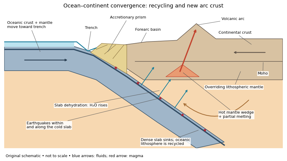
An original ocean–continent subduction cross-section, with slab recycling, fluid release and arc crust production
. Details. The incoming tectonic plate consists of thin oceanic crust, chiefly basalt and gabbro, above colder lithospheric mantle. As that oceanic lithosphere approaches the subduction zone, bending produces the subduction trench. Its cold interior can become denser than the surrounding mantle; the resulting slab pull helps sustain subduction. The descending slab carries both oceanic crust and lithospheric mantle into the interior. Thus the recycled unit is an entire portion of lithosphere, rather than just its crust.
At the subduction trench, some incoming sediment is scraped off and stacked by thrust faults into an accretionary prism. Material can also be added beneath the overriding plate by tectonic underplating. A forearc basin collects sediment between the accretionary prism and the volcanic arc. This is an accreting example: other convergent margins lose upper-plate material through tectonic erosion, so an accretionary prism is not universal.
The cold slab undergoes increasing pressure and metamorphism. Conversion of basaltic rocks and gabbro towards eclogite increases their density, while slab dehydration releases water from hydrated minerals. The rising fluid lowers the solidus of hot peridotite in the mantle wedge, causing flux melting. The usual source of arc magma is therefore the fluid-modified mantle wedge; extensive slab melting is not required. Thermal-petrological calculations show that the depth and amount of slab dehydration depend on the incoming slab's thermal structure.[ref]
Buoyant magma rises through the overriding plate, freezes in igneous intrusions or erupts in the volcanic arc. Fractional crystallization, interaction with existing continental crust and repeated intrusion can produce more evolved arc magmas and add new crust. Some material merely reworks old crust, and simultaneous tectonic erosion can remove it: volcanism alone does not measure net continental growth. Tectonic shortening, folding and thrust faults can thicken and raise the upper plate.
The Wadati-Benioff zone marks earthquakes along and within the cold descending slab. Shallow interface earthquakes reflect unstable slip where the plates are coupled; deeper earthquakes require mechanisms such as dehydration embrittlement and are not simply dry shallow friction operating at every depth. In contrast, the hot mantle wedge deforms mainly by material creep. Together, the subduction trench, accretionary prism, forearc basin, volcanic arc and inclined seismicity connect surface features to the processes recycling and creating crust.
Past exam of the plate tectonics course of the University of Oxford 2022 3 d Solution by Codex 0 2026-10-25
Codex 0 2026-10-25Using the preceding conductive estimate, warmer incoming crust is less dense. Interpret the given as the volumetric coefficient entering . The representative contrast givesFor , that is only about . Let be the vertical thickness of the anomalous slab material in a compensated column. Its mass deficit per unit area is approximately . If uplift adds compensating column mass , isostatic balance gives the thermal buoyancy support of topography:The reference density depends on which interfaces move in the assumed column model. For approximately equal densities and a near-horizontal km crustal layer, this gives m; using and gives about m. A modest dip changes the vertical intersection to approximately and does not change this order of magnitude. Different graphical flux choices and uncertain geometry change the number; they do not justify replacing a km crustal anomaly by a whole km lithospheric anomaly without additional information.
Thus the crust-only thermal contrast can supply tens of metres of isostatic relief, not kilometres. Its sign would favor greater thermal support from the warmer Juan de Fuca crust, so it cannot by itself explain why much of the central Andes stands higher than Cascadia. Crustal shortening and roots, whole-slab thermal structure, phase transformations, hydration, magmatic addition and dynamic stresses can dominate. If the stated expansion coefficient instead meant a linear solid expansion coefficient, the first-order density coefficient would be about three times larger; the estimate would still be well below kilometre-scale mountain relief.
To test isostasy, jointly measure surface topography, free-air gravity anomalies, Bouguer gravity anomalies and crustal thickness from receiver functions and seismic refraction surveys. An Airy isostasy interpretation predicts crustal roots beneath high terrain and a corresponding regional negative Bouguer signal; thermal or compositional compensation predicts different density structure. Compare gravity and geoid observations with compensated-column predictions over a range of wavelengths, and use gravity-topography admittance to test local versus flexural isostasy. A small long-wavelength free-air anomaly can support compensation, but is not a sufficient test by itself. GNSS uplift, leveling and dated marine or river terraces constrain transient or sustained vertical motion; seismic tomography and rock-density estimates constrain deeper buoyancy. Residual relief or gravity after these corrections may require dynamic topography or tectonic support. An actively deforming subduction margin need not satisfy instantaneous local isostatic equilibrium, even if the estimate above is a useful scale comparison.
Past exam of the plate tectonics course of the University of Oxford 2022 3 c Solution by Codex 0 2026-10-25
Codex 0 2026-10-25The supplied plot gives surface heat flux, not a whole-crust mean temperature. At young ages its scatter is substantial. Representative readings suitable for an order-of-magnitude conductive calculation are near Ma and near Ma; plausible graphical ranges are roughly – and –, respectively. These are approximate choices within the plotted population, not uniquely determined statistical means or a digitization of its red curve.
Assume the same normal oceanic crustal thickness km, seafloor temperature , negligible internal crustal heating and a linear conductive profile. These are additional assumptions; the paper supplies conductivity but not thickness. With depth positive downward and the magnitude of the upward flux, Fourier's law givesThis is the crustal mean temperature from conductive heat flow, not the basal temperature, which is twice the excess above . Substitution of givesA sensible rounded answer is therefore about for the young crust and for the old crust, with a representative contrast K. The corresponding basal values are about and . The quoted graphical ranges instead yield mean temperatures about – and –, at the same assumed thickness.
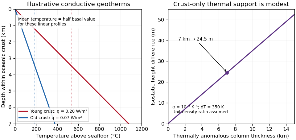
Original conductive temperature estimates and their crust-only thermal-buoyancy scaling; thickness, linear profiles and representative fluxes are explicit assumptions
. Details. The temperatures scale linearly with . Hydrothermal circulation can redistribute heat, especially in young permeable crust, and measurements through sediment need not equal the purely conductive cooling-model flux everywhere. The supplied study explicitly addresses the resulting oceanic heat-flow deficit.[ref]
Oceanic heat flow: implications for global heat loss by Derrick Hasterok and others. Abstract, hydrothermal circulation and low conductive measurements in young seafloor; examination Figure 2 supplies the filtered observations
Thus the calculation gives plausible incoming-crust averages under a stated model, not the entire plate's temperature or its later temperature at depth in the subduction zone. Past exam of the plate tectonics course of the University of Oxford 2022 3 b Solution by Codex 0 2026-10-25
Codex 0 2026-10-25Yes: substantial along-strike segmentation is expected and observed in the Andes, but its geometry and dominant controls need not match Cascadia. The older Nazca Plate has a thicker cooled lithosphere and a larger thermal density excess relative to hot mantle than the young Juan de Fuca system. In a half-space cooling model, thermal thickness scales as , so the age comparison alone gives a thickness ratio . This changes the balance of slab buoyancy, bending resistance and mantle flow; it does not make the margin laterally uniform.
Changes in incoming ridge and plateau buoyancy, hydration, fracture zones, convergence obliquity, upper-plate thickness and motion can all alter slab dip and coupling. The Peruvian and Pampean flat-slab regions illustrate this: long nearly horizontal slab sections contrast with steeper subduction beneath active arc sections. Suppression or displacement of a hot mantle wedge explains why flat-slab subduction can coincide with volcanic gaps and deformation farther inland. The steeply dipping slab beneath much of the central Andes should not be conflated with every Andean segment.
The Juan Fernández Ridge is associated with the Chilean/Pampean transition, while the Nazca Ridge intersects the Peruvian system. However, association is not proof that crustal thickness alone supplies all the buoyancy. Wide-angle seismic observations at the Juan Fernández system found only moderate crustal thickening and motivated consideration of hydration as well as ridge emplacement.[ref]
Seismic investigations of the O'Higgins Seamount Group and Juan Fernández Ridge by Heidrun Kopp and others. Abstract and introduction, seismic profiles, flat-slab association and limits of a crustal-buoyancy explanation
The same combination of slab imaging, geodesy, volcanic chronology and incoming-plate characterization is needed to test causes. Thus the transferable idea is lateral variation in forces and material properties, not an identical three-segment pattern or one age-controlled mechanism. Past exam of the plate tectonics course of the University of Oxford 2022 3 a Solution by Codex 0 2026-10-25
Codex 0 2026-10-25Subduction zone segmentation is the observation that slab structure, fault slip and upper-plate behavior change along a margin; their boundaries need not coincide exactly. In Cascadia, it is documented by several independent measurements.
Onshore GNSS velocities, coastal leveling and tide gauges constrain along-strike changes in megathrust locking and interseismic uplift. Episodic tremor and slip has distinct recurrence and migration patterns, and its occurrence is lower in parts of central Oregon than farther north and south. Coastal geological records constrain differences in coseismic subsidence and the extents of past ruptures. Those observations sample different depths and time windows, so a present-day locking boundary should not automatically be declared a permanent earthquake rupture barrier. A 2014 analysis found persistent central-margin partial creep compatible with reduced uplift, reduced paleoseismic subsidence and lower cumulative slow slip.[ref]
Central Cascadia subduction zone creep by Gina M. Schmalzle and others. Conclusions, central Cascadia approximately 43–46°N and comparison of GPS, uplift and paleoseismic observations
A physically specific hypothesis links these variations to subslab mantle buoyancy. An onshore–offshore seismic tomography study imaged low-velocity asthenosphere beneath northern and southern Cascadia, spatially associated with stronger plate locking and more tremor, with different central-margin structure. Warmer or partly molten asthenosphere can be less dense. Its buoyant traction can push upward against the slab and change contact stresses on the megathrust. Hotspot-influenced material is one proposed northern source; three-dimensional deformation near the Gorda region offers a southern upwelling mechanism.[ref]
Buoyant Asthenosphere Beneath Cascadia Influences Megathrust Segmentation by Miles Bodmer and others. Abstract; sections 3 and 4, onshore–offshore tomography and proposed northern/southern buoyancy sources
There are additional controls. The Siletzia basaltic basement beneath the overriding plate varies in extent and thickness. Its permeability and stiffness can affect fluid escape and fault stresses: poorly drained material can preserve high pore pressure, lower effective normal stress and promote creep. Along-strike changes in incoming plate age, slab dip, fracture-zone hydration, sediment supply and plate-edge stresses can also modify the thermal and frictional environment. Central-margin creep has specifically been associated with the distribution of Siletzia and inferred fluid trapping.[ref]
Central Cascadia subduction zone creep by Gina M. Schmalzle and others. Discussion and conclusions, Siletzia gravity signature and the permeability/fluid-pressure interpretation
How do we distinguish these causes? Offshore and onshore seismic arrays test the geometry of the anomalies; resolution and synthetic-recovery tests determine whether apparent segmentation could result from uneven station coverage. Seismic attenuation, anisotropy, magnetotelluric sounding, rock physics and heat-flow data help separate temperature, melt, water and composition. Gravity anomalies and seismic interfaces constrain basement and slab geometry; geodetic inversions test whether the inferred locking pattern persists across plausible fault geometries. Forward models then ask whether the measured density or pore-pressure contrasts produce stresses and slip patterns of the required size and sign.
Segmentation is observed robustly; a unique cause is not established by spatial correlation alone. Seismic velocity is not a direct density measurement, central creep and deep tremor are not the same phenomenon, and multiple coupled structures can reinforce one another. The buoyant-mantle and upper-plate fluid hypotheses are testable explanations rather than mutually exclusive certainties.
Past exam of the plate tectonics course of the University of Oxford 2022 2 c Solution by Codex 0 2026-10-25
Codex 0 2026-10-25The positive centers in the supplied maps are examples of lunar mascons, especially associated with large impact basins. An empty excavation by itself removes mass and would not explain a positive central anomaly. Basin formation can thin the low-density lunar crust and raise denser lunar mantle beneath the floor; impact melting, collapse and later cooling can also create dense material and lock in a mass excess. Where a basin was later flooded, dense mare basalt adds another contribution. Mare infill is therefore one possible contributor, not a necessary explanation of every mascon.[ref]
NASA's GRAIL Mission Solves Mystery of Moon's Surface Gravity by National Aeronautics and Space Administration. Mission-team account of impact excavation, collapse, cooling and the central mass excess, 30 May 2013
The difference between the maps is the modeled topographic contribution. On a common reference surface, write schematicallyThe free-air gravity anomaly retains relief-related attraction. Rims, excavated floors and central peaks therefore contribute fine structure. The Bouguer gravity anomaly removes the attraction predicted from the measured topography at an assumed crustal density, making internal density and interface structure more apparent. A low basin floor has a negative topographic contribution; subtracting it can enhance an underlying positive central anomaly. Removing a positive rim contribution can weaken a rim high. The supplied lower map is correspondingly smoother at short wavelengths and shows prominent residual basin centers and surrounding rings. This is a change of gravity reduction, not a physical change of the craters.[ref]
GRGM900C: A degree 900 lunar gravity model from GRAIL primary and extended mission data by Frank G. Lemoine and others. Sections 4.2–4.3, gravity predicted from topography and its subtraction to obtain Bouguer gravity
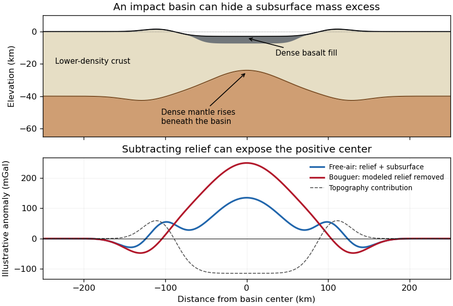
Original schematic showing how dense fill and mantle uplift can outweigh an excavated basin's missing surface mass; illustrative curves are not GRAIL measurements
. Details. For scale, a Bouguer slab approximation gives . A km layer with geophysical density contrast produces about mGal above an ideal infinite slab. Actual basin geometry, burial, porosity and mantle uplift require a finite three-dimensional model. Smaller craters can have central lows, damaged porous interiors or more complex rings; the maps do not imply that every crater has a positive anomaly or that positive anomalies measure basalt thickness uniquely.
Past exam of the plate tectonics course of the University of Oxford 2022 2 b Solution by Codex 0 2026-10-25
Codex 0 2026-10-25I would test whether the ancient farside crust grew locally with an early thermal/compositional gradient or acquired a substantial later accreted layer. The research programme should estimate a globally consistent crustal mass and chronology before tuning either mechanism to a single attractive map.
First, map crustal geometry with independent density constraints. Jointly invert GRAIL gravity and laser-altimeter surface topography, allowing spatially varying density and porosity rather than converting every anomaly to thickness. A new broad-band seismic network should include farside stations, long-lived polar power systems and a communications relay. Natural impacts and moonquakes, supplemented by calibrated active sources near landing sites, would constrain layer velocities, attenuation, crustal interfaces and the crust-mantle boundary. Crossing ray paths and receiver-side conversions are essential to distinguish a thick crust from an incorrect density or velocity assumption. A coherent buried layer or age-correlated discontinuity across the farside would favor addition or stacking; a gradual hemispheric compositional gradient would better support asymmetric local growth. Neither pattern is guaranteed to survive later impacts.
Second, obtain samples that address the initial contrast. Collect geographically distributed ancient highland rocks from both hemispheres, using basin ejecta, central peaks and drilling to sample beneath the impact-gardened regolith. Return samples with mapped geological context. Mineral chemistry and bulk Ca–Al–Mg–Fe abundances would test a primary refractory gradient; crystallization ages would date crustal construction, while shock-reset ages would date overprinting. Isotopic and trace-element measurements could identify an accreted population, but similar isotopes are possible for material derived from the same early debris system. A young deposit draped over older crust would favor accretion; coeval flotation-related crust with a systematic chemical gradient would favor local asymmetric differentiation. Multiple sites are necessary because a single basin's ejecta can mix distant sources.
Third, measure the thermal and volcanic consequences. Place shielded, sufficiently deep heat flow probes in representative highlands and mare terrains. Combine their geothermal gradients and measured thermal conductivity with orbital gamma-ray constraints on heat-producing elements. Map mare volumes and eruption ages, rather than only their exposed areas, to separate melt production from storage and eruption efficiency. A strong correlation between late volcanism, subsurface heat producers and high inferred mantle temperatures would support radiogenic amplification, while old crustal asymmetry without that correlation would show that later heating is not the entire cause.
Finally, compare forward models against withheld observations. Couple irradiation, vapor transport, condensation, lunar magma ocean mixing and crystallization for the thermal scenario; couple orbital evolution, impact deposition, mixing and later viscous relaxation for accretion. Account for later true polar wander before treating present-day hemispheric orientation as the original formation geometry. Require each model to conserve mass and energy and to reproduce the independent thickness, chemistry, age and volcanic data within their uncertainties. Vary unknown initial conditions and compare predicted observables at sites not used for calibration. The discriminating outcome is a conjunction such as a coherent accreted unit with a consistent emplacement age, or an ancient chemical gradient quantitatively consistent with transport under Earth irradiation. A lower gravity misfit alone cannot establish the historical mechanism, because gravity is a nonunique inverse problem.
Past exam of the plate tectonics course of the University of Oxford 2022 2 a Solution by Codex 0 2026-10-25
Codex 0 2026-10-25The lunar crustal dichotomy combines several observables: the far side of the Moon has generally thicker, higher, feldspathic lunar highlands, whereas most visible lunar maria and the Procellarum KREEP Terrane occupy the near side of the Moon. These need not all have been produced by a single event. The old anorthosite crust formed mainly before the younger basaltic mare infill. Gravity-based crustal models combined with sample and seismic constraints demonstrate that crustal thickness and porosity must be considered alongside surface color.[ref]
The Crust of the Moon as Seen by GRAIL by Mark A. Wieczorek and colleagues. Science 339, p. 671, crustal density, porosity and thickness constraints
An early thermal and chemical asymmetry is one physically motivated option. In a lunar magma ocean, crystallizing, relatively buoyant plagioclase can accumulate to form feldspathic crust. On a young Moon that rapidly attained synchronous rotation, radiation from a still-hot nearby Earth would preferentially warm the nearside. The primordial Earthshine hypothesis proposes that this imposed a thermal gradient in the atmosphere and accreting material: crust-forming refractory constituents condensed preferentially toward the cooler farside, favoring thicker farside crust. This is more specific than simply saying that the farside cooled faster; it requires a persistent hemispheric chemical contrast.[ref]
Earthshine on a Young Moon: Explaining the Lunar Farside Highlands by Arpita Roy and others. Sections 2–4, early tidal locking, condensation gradient and survival of compositional asymmetry
Subsequent concentration of incompatible elements in KREEP-rich late liquids can help preserve a thermal asymmetry: potassium, uranium and thorium provide radiogenic heating, supporting later melting in the nearside source region. Lower surface elevation and a thinner crust also facilitate some magma transport and pooling, although crustal thickness alone cannot specify eruption rates. The origin of the crustal contrast and the later production and emplacement of mare basalt are separate parts of the explanation.
The thermal option is consistent with a thick feldspathic farside crust, a hemispheric chemical contrast and the existence of an early hot Earth. It is not uniquely demonstrated by those observations. Vigorous magma-ocean mixing could erase the proposed gradient; the required irradiation must persist during the relevant condensation and crust-building interval, not merely occur at some early time. A failure to find the predicted bulk compositional contrast in demonstrably ancient deep crust, or a chronology placing the asymmetry after complete crystallization, would challenge this particular mechanism. The existence of farside mare deposits and large thin-crust basins also warns against treating thickness as an on/off volcanic switch.
Accretion of a smaller companion is a contrasting option. A low-speed collision of a smaller co-orbiting moon with the lunar farside could add a broad layer of relatively cold silicate material rather than excavate an ordinary deep crater. Numerical impact models demonstrate that such a depositional event can build thick highlands and displace underlying residual liquid toward the opposite hemisphere.[ref]
Forming the lunar farside highlands by accretion of a companion moon by Martin Jutzi and others. Nature 476, pp. 69–72, accretionary collision model
Broad crustal excess and asymmetric evolved material are compatible with that mechanism, but are not unique evidence for it. The necessary companion, collision timing and impact geometry must be dynamically feasible. A predicted buried depositional interface, age discontinuity or lateral fabric should survive somewhere; their systematic absence in well-resolved, unmodified ancient crust would count against the model. Closely related bodies could have similar isotopes, so failure to find a large isotopic difference alone would not disprove accretion.Both scenarios allow later basin impacts, partial melting of the lunar mantle and mare emplacement to modify the original contrast. A useful explanation must reproduce crustal mass, chemistry, chronology and volcanic distribution together, and state which observations would distinguish its initial cause.
Past exam of the plate tectonics course of the University of Oxford 2022 1 c Solution by Codex 0 2026-10-25
Codex 0 2026-10-25The geological record is a collection of thermometers with different sampling biases, not a direct time series of the whole mantle.
Primary melt compositions constrain melting temperatures. Reconstruct primary magma compositions from dated, suitably unaltered basalts by correcting for fractional crystallization and checking equilibrium with olivine. Experimental phase equilibrium constraints and mineral–melt thermometers then constrain the pressure and temperature of melt generation. In laboratory calibrations, a candidate melt and mineral assemblage are equilibrated at controlled pressure and temperature, quenched, and their crystals and glass analyzed. Repetition across adjacent conditions brackets the relevant phase equilibrium boundaries. Correcting for decompression and latent heat then allows comparison as mantle potential temperature. Age-controlled, non-arc basalt suites are especially valuable for separating changes in ambient mantle from exceptional mantle plumes. The 2010 reconstruction by Claude Herzberg and colleagues combines this approach with the temporal distribution of high-Mg parental melts.[ref]
Thermal history of the Earth and its petrological expression by Claude Herzberg and others. Sections on primary magma reconstruction and comparison of non-arc basalts with komatiites
Komatiites provide evidence for unusually hot melting, with qualifications. Many ancient high-Mg lavas, their olivine compositions and spinifex textures indicate large degrees of melting and high parental temperatures. Their abundance in Archean terrains and rarity in the recent record are consistent with a hotter past. However, a hot mantle plume, dissolved water, unusual source composition or crystal accumulation can change the interpretation. A komatiite temperature is not automatically the ambient mantle temperature, and spinifex texture alone is not a calibrated thermometer.
Melting residues and crustal products provide independent checks. Depleted peridotite mantle xenoliths, preserved mineral chemistry and compatible-element depletion constrain former melt fractions. More extensive melting can produce thicker mafic crust and more refractory residual mantle; these are predictions to compare with preserved rock packages and seismic or petrological constraints on ancient lithosphere. Metamorphic facies and pressure–temperature paths provide contextual evidence about geothermal regimes, but tectonic burial, decompression and preservation can mimic temporal changes. They do not directly measure .
The most persuasive inference is therefore agreement between dated melt thermometry, melting residues and their predicted crustal consequences, while separating source fertility, volatile content, mantle plume anomalies, alteration and selective preservation. Those controls explain why hotter ancient melting is better established than one exact global cooling curve.
Past exam of the plate tectonics course of the University of Oxford 2022 1 b Solution by Codex 0 2026-10-25
Codex 0 2026-10-25Distinguish the depth-dependent mantle temperature from mantle potential temperature : the latter is the temperature a parcel would have after reversible decompression in an adiabatic process to a chosen reference pressure. A convecting mantle is approximately adiabatic through much of its interior, with steep thermal boundary layers near the surface and the core-mantle boundary. It is neither isothermal nor wholly molten.
Early accretion, large impacts and gravitational planetary differentiation supplied heat; metal segregation released gravitational energy and extensive melting could produce a magma ocean. Rapid surface heat loss then crystallized much of the silicate mantle. Subsequent evolution reflects competition between radiogenic heating, heat entering from the core and heat carried out through the upper boundary. In a schematic mantle energy balance,Here is mantle heat capacity, mantle radioactive power and heat leaving the mantle; continental crustal radioactive production is not included in . The convective Urey ratio compares internal production with mantle heat loss. A value below one does not alone prove cooling, because core heat also enters; cooling requires . Radioactive decay reduces the heating supply, while mantle convection, plate tectonics, melt extraction and changing viscosity control the heat loss. A hotter mantle does not automatically imply proportionally faster plate motion: melting, dehydration and boundary strength can alter that relationship.
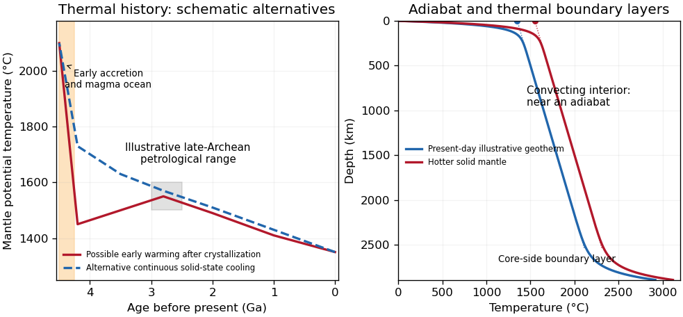
Original schematic thermal histories and mantle geotherms; curves illustrate alternatives rather than reproduce observations or fit a particular thermal model
. Details. The robust long-term picture is an energetic early Earth followed by substantial cooling and a presently mostly solid, convecting mantle. The shape of the solid-state history is less certain. Petrological reconstructions commonly place late-Archean ambient above modern values. One reconstruction infers about – at – Ga versus about today, and permits warming before that late-Archean maximum after the initial magma-ocean cooling.[ref]
Thermal history of the Earth and its petrological expression by Claude Herzberg and others. Abstract and discussion of the late-Archean temperature maximum, EPSL 292, pp. 79–88
This is a model-dependent ambient-mantle history, not proof that the accreting Earth was cooler than the Archean mantle or that every mantle reservoir followed one curve. An early molten transient, subsequent solid-state heating or cooling, and later secular cooling must be distinguished. Past exam of the plate tectonics course of the University of Oxford 2022 1 a Solution by Codex 0 2026-10-25
Codex 0 2026-10-25The decisive change was from moving continents within a supposedly permanent ocean floor to moving coherent tectonic plates that include both continental and oceanic lithosphere. Several independent observations made that change testable.
Continental connections supplied the initial problem. In the early twentieth century, Alfred Wegener assembled matching continental margins, correlatable rock belts and mountain chains, shared fossil assemblages, and paleoclimate indicators into the case for continental drift. Reassembling Gondwana, for example, makes geographically separated glacial deposits and striation directions compatible with one ice-sheet system. Fits at the continental shelf edge are physically more meaningful than exact fits to modern coastlines, which have been modified by erosion and sea-level change. The evidence suggested relative movement, but did not justify the proposed forces: continents cannot readily plough independently through strong oceanic rock. A convincing mechanism and independent motion measurements were missing.
Oceanography changed the boundary conditions. Echo-sounding surveys revealed a connected spreading ridge system, axial valleys, subduction trenches and long fracture zones. Seismic refraction surveys established systematic differences between continental and oceanic crust. Thin oceanic sediment cover, high ridge heat flux and the lack of very old exposed oceanic basement made permanent, ancient ocean basins increasingly implausible. Harry Hammond Hess proposed creation of oceanic lithosphere at ridges and recycling at trenches: seafloor spreading without requiring an expanding Earth. Slow mantle convection supplied a physically plausible connection between surface transport and internal heat loss. The mechanism need not have been completely quantified before its kinematic predictions could be tested.[ref]
Developing the theory in This Dynamic Earth. Sections Ocean floor mapping, Seafloor spreading and recycling of oceanic crust
Magnetic records supplied a clock and a speedometer. Dated continental lavas established a sequence of geomagnetic reversals. Marine magnetometers then found elongated, approximately paired marine magnetic stripes on either side of ridges. The 1963 interpretation by F. J. Vine and D. H. Matthews combined repeated reversals with seafloor spreading: cooling basalt locks in remanent magnetization, and continuous motion converts a time sequence into a spatial sequence. If a polarity interval lasts and occupies width on one ridge flank, its half-spreading rate is . Matching several reversals tests the predicted sequence, rather than merely fitting a single stripe.[ref]
Magnetic Anomalies Over Oceanic Ridges by F. J. Vine and D. H. Matthews. Nature 199, pp. 947–949, magnetic striping and the spreading interpretation
Different apparent polar wander paths for different continents also became mutually consistent after continental reconstruction, favoring relative continental motion over independent magnetic-pole histories.Earthquakes identified creation, translation and consumption. Improved global seismology located shallow earthquakes along ridges and transforms, and dipping Wadati-Benioff zones beneath trenches. Their progressive focal depths identified cold, coherent slabs entering the mantle. Focal mechanisms showed extension at spreading boundaries, tangential slip at transforms and convergence at trenches. In 1965, John Tuzo Wilson's transform fault interpretation made a particularly discriminating prediction: active slip occurs between offset ridge segments, with a sense that can be opposite to that inferred by treating the entire lineament as an ordinary offset fault. The outer fracture zones are inherited traces, not continuing active plate boundaries. Agreement of focal mechanisms with the transform prediction linked magnetic and seismic evidence.
The late-1960s synthesis made these observations one quantitative theory. Relative motion of rigid tectonic plates on a sphere can be described by an Euler angular velocity vector, with . Spreading rates, transform azimuths and slip directions must fit the same rotation, and relative angular velocities must close around plate circuits. The resulting framework accounted for global boundary geometry and earthquake mechanisms without moving continents separately from the seafloor. Deep-ocean drilling beginning in 1968 subsequently confirmed that basement and overlying sediments generally become older away from ridges; this was a powerful confirmation of an already emerging synthesis, not a prerequisite discovered decades earlier.[ref]
Developing the theory in This Dynamic Earth. Sections Magnetic striping and polar reversals, Concentration of earthquakes, and discussion of the 1968 drilling programme
Thus plate tectonics succeeded through agreement between geological reconstruction, magnetic chronology, ocean-floor structure, seismology and rigid-plate kinematics. Modern satellite geodesy verifies motions directly, but belongs to the later confirmation of the theory, not its original 1960s evidence.
Past exam of the physics of atmospheres and oceans course of the University of Oxford 2022 6 d Solution by Codex 0 2026-10-25
Codex 0 2026-10-25Coastal Kelvin-wave radiation of long Rossby waves requires a common phase convention to match the two waves. The supplied Rossby wave formula conventionally multiplies , while the coastal expression uses . Since physical fields are real, matching may use the complex-conjugate representative; in either convention the boundary forcing fixes the absolute frequency and alongshore wavenumber. Thus and .
For , the shallow-water Rossby-wave dispersion relation reduces toChoosing recovers the printed magnitude relation. Both the zonal phase velocity and zonal group velocity are approximately , so the long Rossby waves carry the coastal signal westwards into the basin.
The coastal condition alone does not guarantee a long zonal wavelength. Since , matching requires and hence the stronger consistency conditionFor example, at a coastal wavenumber with gives , which is not asymptotically small even though the meridional wavelength is long. Thus the source's proposed excitation is possible at sufficiently low frequency; it is not an automatic consequence of its meridional long-wave assumption.
At N or S the beta plane parameter isTaking a representative Pacific basin width m givesA width of – m gives roughly – years. This is propagation near latitude, not an equatorial calculation. Slow Rossby wave adjustment supplies a basin-scale delay relevant to El Niño–Southern Oscillation: changing thermocline depth can affect later sea surface temperature and coupled wind forcing. Reflection and coupling may help produce interannual memory, but this travel-time estimate alone does not establish a climate oscillation or its period.
Past exam of the physics of atmospheres and oceans course of the University of Oxford 2022 6 c Solution by Codex 0 2026-10-25
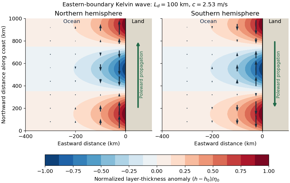
Codex 0 2026-10-25Use Earth's rotation rate and the Coriolis parameter . At ,The Kelvin waves propagate polewards along the eastern boundary: northwards at N and southwards at S. The positive Rossby deformation radius uses ; the source's expression must be interpreted as a magnitude in the southern hemisphere.
The east-west e-folding distance is approximately km, orof longitude. With the coast at and ocean at , a northern-hemisphere snapshot can be writtenAt a positive thickness crest, the thermocline is depressed and the alongshore velocity points polewards; a negative thickness trough reverses that velocity. In the southern hemisphere replace by in the propagation and in . The envelopes of both thickness and alongshore velocity decay offshore, and the cross-shore velocity vanishes.
Past exam of the physics of atmospheres and oceans course of the University of Oxford 2022 6 b Solution by Codex 0 2026-10-25
Codex 0 2026-10-25Put and . With and complex dependence , the northward momentum equation and continuity equation giveThus . Write the signed phase velocity as , so . The eastward momentum equation is the transverse geostrophic balance . HenceThe decaying sign is selected by which side of contains the ocean. For an eastern boundary the ocean occupies , so decay offshore requires . Consequently the Kelvin wave moves northwards in the northern hemisphere and southwards in the southern hemisphere, with the coast respectively on its right and left. The positive offshore decay length isThe sign of reverses the propagation direction and the sign of relative to , but not the speed or offshore decay length. The real physical fields are the real parts of the complex solution. At the equator itself this local f-plane coastal solution loses its finite trapping scale.
Past exam of the physics of atmospheres and oceans course of the University of Oxford 2022 6 a Solution by Codex 0 2026-10-25
Codex 0 2026-10-25Use a shallow, homogeneous active upper layer of mean thickness and mass density , over a much deeper, effectively stationary layer with mass density . The Boussinesq approximation keeps the small density contrast only in buoyancy, giving reduced gravity . The hydrostatic approximation and shallow-water approximation make horizontal velocity nearly depth independent and turn the interface slope into the horizontal force .
Linearize about rest and uniform , with , neglecting products of perturbations and convective acceleration. The f-plane approximation sets the Coriolis parameter to constant . Neglect wind forcing, viscosity, entrainment and bottom drag. The two horizontal momentum equations then balance local acceleration, the Coriolis force and the pressure gradient. The signs and follow from eastward and northward coordinates.
The thickness equation is the linearized conservation of mass law: horizontal divergence decreases , while horizontal convergence increases it. Here is active-layer thickness, not total ocean depth, and rather than gives the restoring force because the motion principally displaces the thermocline.
Past exam of the physics of atmospheres and oceans course of the University of Oxford 2022 5 d Solution by Codex 0 2026-10-25
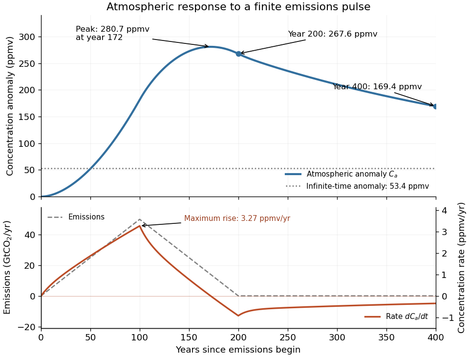
Codex 0 2026-10-25Here , , , and , in the stated reservoir units. The exact characteristic coefficients are and , givingThe leading separation estimates give yr and yr if finite is retained, or yr if is also sent to infinity. Thus ; a ratio of ten warrants using the exact values for the requested sketch.
Assume initially zero anomalies in all reservoirs. The atmospheric impulse response, obtained by decomposing into the three normal modes, iswith , , and , in ppmv/GtCO. The checks and fix the instantaneous injection response and its initial decay.
The concentration is the convolution . To evaluate it transparently, define for , andsetting every when . Expressing the triangular emission history as givesHere times are in years and has the corresponding emission-ramp units. Differentiating or evaluating the convolution givesThe maximum concentration occurs earlier than the end of emissions, at approximately year , with ppmv. Initially there is a short adjustment over ; the curve then rises, turns over as emissions fall, and continues declining after year 200 as the deep ocean takes up carbon dioxide.
The total emitted mass is the area of the emission triangle, GtCO. All reservoirs eventually share one concentration, so conservation of mass gives
Pinned article: Introduction to the OurBigBook Project
Welcome to the OurBigBook Project! Our goal is to create the perfect publishing platform for STEM subjects, and get university-level students to write the best free STEM tutorials ever.
Everyone is welcome to create an account and play with the site: ourbigbook.com/go/register. We belive that students themselves can write amazing tutorials, but teachers are welcome too. You can write about anything you want, it doesn't have to be STEM or even educational. Silly test content is very welcome and you won't be penalized in any way. Just keep it legal!
Intro to OurBigBook
. Source. We have two killer features:
- topics: topics group articles by different users with the same title, e.g. here is the topic for the "Fundamental Theorem of Calculus" ourbigbook.com/go/topic/fundamental-theorem-of-calculusArticles of different users are sorted by upvote within each article page. This feature is a bit like:
- a Wikipedia where each user can have their own version of each article
- a Q&A website like Stack Overflow, where multiple people can give their views on a given topic, and the best ones are sorted by upvote. Except you don't need to wait for someone to ask first, and any topic goes, no matter how narrow or broad
This feature makes it possible for readers to find better explanations of any topic created by other writers. And it allows writers to create an explanation in a place that readers might actually find it.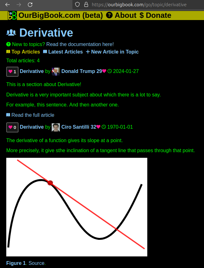
Figure 1. Screenshot of the "Derivative" topic page. View it live at: ourbigbook.com/go/topic/derivativeVideo 2. OurBigBook Web topics demo. Source. - local editing: you can store all your personal knowledge base content locally in a plaintext markup format that can be edited locally and published either:This way you can be sure that even if OurBigBook.com were to go down one day (which we have no plans to do as it is quite cheap to host!), your content will still be perfectly readable as a static site.
- to OurBigBook.com to get awesome multi-user features like topics and likes
- as HTML files to a static website, which you can host yourself for free on many external providers like GitHub Pages, and remain in full control

Figure 2. You can publish local OurBigBook lightweight markup files to either OurBigBook.com or as a static website.
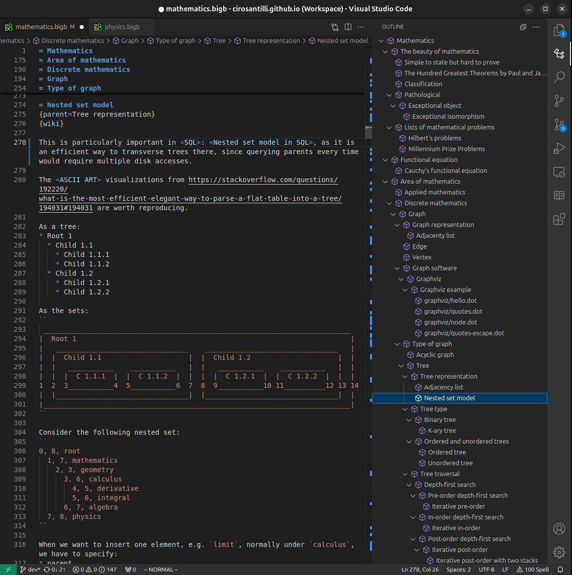
Figure 3. Visual Studio Code extension installation.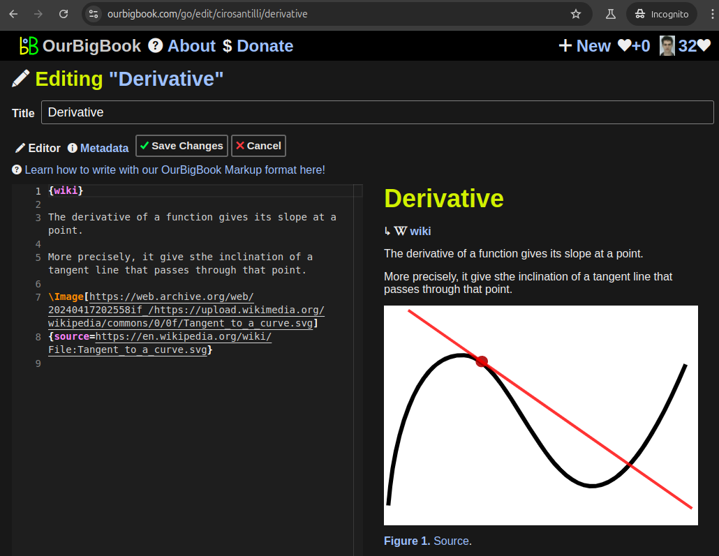
Figure 5. . You can also edit articles on the Web editor without installing anything locally. Video 3. Edit locally and publish demo. Source. This shows editing OurBigBook Markup and publishing it using the Visual Studio Code extension. 
- Infinitely deep tables of contents:



All our software is open source and hosted at: github.com/ourbigbook/ourbigbook
Further documentation can be found at: docs.ourbigbook.com
Feel free to reach our to us for any help or suggestions: docs.ourbigbook.com/#contact